
-
 10435 Hits
-
 87.31% Score
-
 24 Votes
|
|
Mountain/Rock |
|---|---|
|
|
41.22173°N / 122.4252°W |
|
|
Summer, Fall |
|
|
7070 ft / 2155 m |
|
|
Overview
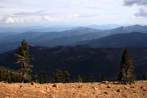
 "Gray Rock Dome" stands vigil over the headwaters of the Sacramento River
Although prominently visible from all over the Mt. Shasta area, “Gray Rock Dome” has nonetheless remained officially unnamed and rarely climbed. The dome is one of a dense cluster of peaks that can be seen west of the community of Mount Shasta City, dominating the horizon south of Mt. Eddy. Though dramatic and craggy, these peaks are all anonymous, but offer some of the best summits in the area. The three highest peaks, “Harry Watkins”, “Gray Rock Dome” and “Castle Peak” are all found in the western end of the Castle Crags Wilderness, a small wilderness area that packs a phenomenally scenic punch. After “Castle Crags Mountain”, “Gray Rock Dome” is the highest peak in the wilderness area. Despite its anonymity the peak is a spectacular monument, standing atop a granite wonderland with a trio of excellent lakes resting at its western base.
 "Gray Rock Dome" from the trailhead
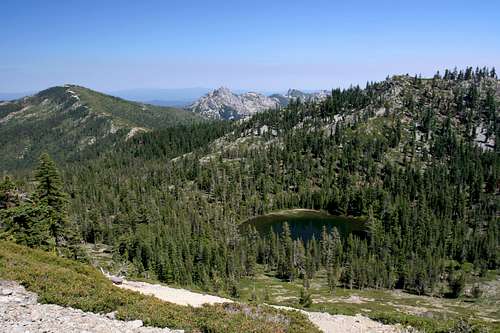
The western portion of the Castle Crags Wilderness is distinct from the well-known eastern half. While the Castle Crags themselves are smoothly polished, high quality granite similar to what one would find in the Sierra Nevada, the western half is much more typical of the Klamath Mountains, composed of a number of different rock types. Granite is common, particularly around “Harry Watkins” which lies immediately south of “Gray Rock Dome”. The dome itself is made of metamorphic rock. Much of the peak is talus, although there are significant intrusions of solid rock. The west face of the dome towers above the Gray Rock Lakes Basin, the only true glacial cirque in the wilderness area. Castle Lake, another glacial lake, lies just outside the wilderness boundary, though some of Castle Lake’s subsidiary bodies of water, Little Castle Lake and Heart Lake are within the wilderness area. The Gray Rock Lakes Basin contains three lakes. Solitary Scott Lake is found on the eastern slopes of “Gray Rock Dome” and provides an excellent and isolated camp for those searching for isolation.
A trip up to the summit of “Gray Rock Dome” provides spectacular views of the Grey Rock Lakes basin, the Castle Crags, Mt. Eddy, Black Butte Mt. Shasta and the Strawberry Valley. All of this can be obtained with guaranteed solitude, a treat in the busy Mt. Shasta area. However, there is a stiff price tag for achieving the summit. No trails lead to the top of “Gray Rock Dome” and a difficult bushwhack must be undertaken to get to the base of the dome.
Castle Crags Wilderness
 Looking east, along the spine of the Castle Crags Wilderness
Located in the Trinity Divide, the Castle Crags are a familiar sight to those traveling on Interstate 5. Rising suddenly out of the forested ridges lining the Sacramento River Canyon, the serrated granite spires of the Crags are an ominously enticing formation that beckons the intrepid to explore them. Most who do succumb to the Crags allure access them through Castle Crags State Park, which is located on the southeastern corner of the formation. Most are unaware that very little of the Castle Crags actually lie in the state park. In truth, the bulk of the Crags are found in Shasta-Trinity National Forest’s Castle Crags Wilderness. Although small with only 10,500 acres, the wilderness area packs an enormous amount of scenery into its small area.
The eastern half of the Castle Crags Wilderness is the home of the Castle Crags themselves. Further west, the mountains get much higher than the spires of the Crags, although they remain composed of granite with occasional intrusions of metamorphic rock. Here in the western half of the wilderness area is the cluster of high peaks around the Gray Rock Lakes basin. “Harry Watkins” is the tallest at 7,200, while “Gray Rock Dome” is only a little shorter at 7,070. Another lake basin is found between the Crags and the Gray Rock Lakes, however, the main lake in the basin, Castle Lake, lies just outside the wilderness boundary. Two smaller lakes, Little Castle Lake and Heart Lake, are found inside the wilderness boundary, high in cliffs above Castle Lakes.
The Pacific Crest Trail travels 14 miles through the Castle Crags Wilderness’ southern flanks.
Trinity Divide
 The Castle Crags Wilderness from the summit of Mt. Eddy
The Castle Crags Wilderness is the only wilderness area in the Trinity Divide. This region is the eastern most subrange of the Klamath Mountains. Sometimes called the Trinity Mountains, the Divide is not to be confused with the Trinity Alps, which lie directly to the west. Two rivers, the Klamath and the Trinity, as well as their various tributaries dominate the Klamath Mountains. The Trinity Alps provide the bulk of the water that flows in the Trinity River. On the other hand, while the Trinity Divide does provide some water to the river it is even more important sense it forms the divide between the Trinity River’s watershed and watershed of the Sacramento River. The waters on the west side of the range ultimately find there way to the Pacific Ocean by way of the Klamath River while the waters on the east side reach the sea through the Sacramento River at San Francisco Bay. The Trinity Divide is topped by Mt. Eddy, the highest peak in the Klamath Mountains.
Getting There
 Gray Rock Lake lies at the foot of "Gray Rock Dome"
From the town of Mt. Shasta, head west on W. Lake, crossing over I-5. At the stop sign, turn left onto Old Stage Road. After 0.25 miles, veer right onto WA Barr Road. Continue south, crossing over the dam that impounds the Sacramento River and forms Lake Siskiyou. From the dam, continue 9 miles to the west, passing the lake and continuing up the Sacramento River. After 9 miles, turn left, crossing over the Sacramento River on a Forest Service bridge. Veer left after the bridge, then make a sharp right hand turn onto Forest Road 39N45. The well-maintained dirt road may not be signed, but it is hard to miss. It parallels the river for 1.25 miles before intersecting Forest Road 39N41. At the intersection, turn left onto FR 39N41. Again, this road may not be signed, but the level of wear on the road makes it obvious which way is correct. Continue up the road for 1.2 miles. At this point the road’s condition degrades dramatically and those with sedans or who are uncomfortable negotiating steep, severely eroded routes should park here and hike the 0.25 miles to the Gray Rock Lakes trailhead. For those with 4x4, simply continue to the trailhead.
Red Tape
 Castle Crags and Scott Lake
A permit is required for campfires.
Shasta-Trinity National Forest
3644 Avtech Parkway
Redding, CA 96002
(530)226-2500
Mount Shasta Ranger Station
204 West Alma
Mt. Shasta, CA 96067
(530)926-4511
Camping
Dispersed camping is allowed throughout the area. The nearest campground is four miles west of the bridge, on the eastern end of Gumboot Lake. A large campground is located on the southwest shore of Lake Siskiyou, eight miles east of the bridge.Good campgrounds are found around Gray Rock Lake, especially on the northern and eastern shores. Isolated and interesting campsites can be had at Scott Lake and the saddle between "Gray Rock Dome" and "Castle Crags Mountain". Water is available at oth sites.
When To Go
 The Gray Rock Lakes Basin
The Trinity Divide is often buried in snow until mid-June. The hiking season generally lasts from then until October. The road to Gray Rock Lakes is not plowed and particularly treacherous in winter. Access is difficult before the temperatures increase.