
-
 17305 Hits
-
 91.14% Score
-
 34 Votes
|
|
Area/Range |
|---|---|
|
|
41.31949°N / 122.47928°W |
|
|
Spring, Summer, Fall, Winter |
|
|
9025 ft / 2751 m |
|
|
Overview
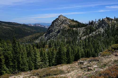
 The Grey Rocks viewed from Cerulean Lake
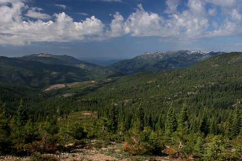
The Trinity Divide is the tallest range in California’s vast Klamath Mountains. It lies just west of mighty Mount Shasta, forming the eastern breastwork of the Klamaths. It is a range of contrasts, boasting massive granite spires and barren wastes where little vegetation manages to eek out an existence, to gorgeous alpine lakes in deep glacial cirques. The Divide is a range of contrasts in more than just the diversity of its landscapes. Just as the Trinity Divide separates the headwaters of the Trinity and Sacramento Rivers, the range itself is separated into the known and unknown. While it is often viewed from I-5 as the freeway courses along the feet of the range, there are whole sections of the Divide that are so forsaken in the public mind that fewer than a dozen visitors a year, if any at all, might venture into the area. For those who make the effort to explore the Trinity Divide, they will discover a beautiful mountain range that offers year-round recreation; from hiking and backpacking on excellent trails to rock climbing on epic granite walls to excellent skiing. In addition to the expansive recreational activities the Trinity Divide boasts ease of access, opportunities for solitude, spectacular scenery and the chance to observe the continually changing appearance of Mount Shasta.
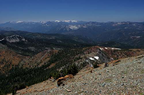
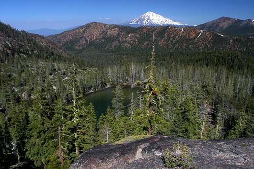
 The Deadfall Lakes Basin from Mount Eddy
The Trinity Divide is so named because it constitutes the divide between the headwaters of the Sacramento and Trinity Rivers. These rivers rise high in the mountains, beginning their journey to the sea at numerous lakes and meadows strewn about the range. The range contains 40 named lakes, several unnamed smaller lakes and dozens of creeks and streams. While it lacks the granite splendor of the nearby ranges like the Trinity Alps, the Trinity Divide has an alpine nobility of its own. From the many spires and domes of the Castle Crags to the forsaken glory of the Grey Rocks to the alpine beauty of Mount Eddy, the Trinity Divide measures up favorably with other more well known mountain regions. While the range is overshadowed by Mount Shasta, it may be that this is not a bad thing, since it leaves a fabulous mountain playground far less traveled for those willing to root out its excellent qualities.
 The Castle Crags
It is ironic that Trinity Divide, the most heavily used range in the Klamath Mountains, is also the most anonymous and contains some of northern California’s most spectacular forgotten mountains. Those familiar with the Klamaths are readily able to point to the Trinity Alps, the Marble Mountains, the Siskiyous and it is not uncommon for someone to have heard of the Russians or the Yolla Bollys. Ask someone about the Trinity Divide, and one is most likely to meet an unknowing shrug. The reasons for this are manifold. Chief among them are the overwhelming presence of Mount Shasta. Many grand mountains would fade to minor significance in the face of the lonely mountain. When people do take their eyes off of Mount Shasta and take notice of the Trinity Divide, it is usually to observe the fantastic Castle Crags or towering Mount Eddy, the Divide’s highest point. These formations, while well know seem disparate and unconnected. There is little information explaining the range as a cohesive whole. Moreover, from afar, the rest of the range appears to be a forested set of ridges. Fortunately, this conceals the true nature of the Trinity Divide.
History
 Castle Dome presides over Root Creek Falls
Wintun Indians originally inhabited the mountains of the Trinity Divide. Prospectors from the Gold Rush in the Sierra Nevada found there way north in the early 1850’s and sparked several rushes in areas throughout the Klamath Mountains, particularly in the Trinity Alps and the mountains around Yreka. The area around the Castle Crags, particularly in the headwaters of Castle Creek, was also prospected and a few mines were established, although the area was not as profitable as the nearby Trinity Alps. Pressure from the miners aroused the ire of the Wintun and in 1855 the Battle of the Castle Crags took place. The location of the battle is believed to be on the flanks of “Castle Peak”, near Heart Lake. This is reportedly the last battle in the American West in which the Native-Americans fought solely with bows and arrows. Famed western poet Joaquin Miller participated in the battle and was wounded in the thigh and cheek (some now claim he in fact did not participate in the battle). Miller wrote an account of the conflict in a short work called “Battle of the Castle Crags”. While the mines were playing out, the Southern Pacific Railroad built its line up the Sacramento River Canyon, which opened the area up to commercial logging and tourism. Logging was particularly heavy on the western side of the range, where it is ongoing to this day. Though logging does occur on the east side of the Divide, it is only a small fraction of the west side’s activity.
 Castle Lake
In the 1930’s, local citizens moved to raise funds to protect a portion of the Castle Crags the Trinity Divide’s most prominent feature. Enough money was raised to establish the Castle Crags State Park. The bulk of the Crags and surrounding mountains passed under the stewardship of what is now the Shasta-Trinity National Forest. In 1984 the Castle Crags Wilderness was established as part of the California Wilderness Act. Since then, no lands have been added to the wilderness, though several thousand acres of adjacent lands retain their wilderness characteristics. No other wilderness areas exist in the range.
The Trinity Divide hosted a couple of resorts in the late 19th century. Ney Springs Resort was located in Ney Springs Canyon, 4 miles downstream from the headwaters of Ney Springs Creek at Little Castle Lake. The resort featured several large structures, a promenade and fountains. All that remains today are some foundations, a cistern and a retaining wall along a trail leading down to the creek. The Shasta Springs Resort was located on the Sacramento River and profited from its location on the Southern Pacific rail line. Today the resort is the property of the St. Germain Foundation
Geography Overview
 Looking south at the Trinity Divide from the top of Mount Eddy
The Trinity Divide is one of the easternmost subranges of the Klamath Mountains, a knot of peaks that extend from the North Yolla Bollies west of Red Bluff, California, to the Rogue River, in southwestern Oregon. The Klamaths are one of the wildest, least populated regions in the Lower 48, containing 1.25 million acres of designated wilderness, hundreds of thousand more unprotected acres of wilderness and one of the lowest populations densities in America.
Although there is no precise tabulation, the Klamath Mountains contain roughly 15 subranges. This calculation depends on how one counts some overlapping areas. The largest of these are the Trinity Alps, in the center of the Klamaths and the Siskiyou Mountains, which stretch across the California – Oregon border. The smallest subrange is the Russian Mountains, which form a small, high mountain corridor connecting the larger Trinity Alps and Marble Mountains regions. Though the Trinity Alps is easily the most rugged part of the Klamaths, containing the most spectacular terrain and densest concentration of the highest peaks, it does not in fact contain the highest point in the Klamaths. That distinction goes to the Trinity Divide’s Mount Eddy.
The Trinity Divide constitutes the eastern flank of the Klamath Mountains. East of the range is massive Mount Shasta and the Cascade Range. The Divide stretches from China Mountain in the north to Red Mountain in the south. Though only 22 air miles separate the two peaks, the Trinity Divide embodies the best qualities of the Klamath Mountains, including jagged granite spires, high peaks, glacial lakes, waterfalls, spectacular vistas and extreme solitude.
A Trio of Trinities: Trinity Alps, Trinity Divide, and Trinity Mountains
An unfortunate aspect of much of the Klamath Mountains is the ubiquitous repetition of names. The same monikers appear in many different subranges of the Klamaths and even appear in the same range on several occasions. In the Trinity Alps, 3 separate lake basins containing a combined 9 lakes are all some permutation of the term “boulder”. Another example are the three peaks in the Klamaths named Boulder Peak.
 Looking west to the Trinity Alps from the top of Mount Eddy
This confusing repetition of names even extends to the naming of the subranges. The Klamath Mountains boast three ranges all containing the word Trinity. This comes from the Trinity River, the major watershed of the southern two-thirds of the Klamath Mountains. This trio of Trinities obviously includes the Trinity Divide and the aforementioned Trinity Alps. There is also a range called the Trinity Mountains. A map showing their location can be found here.
The Trinity Alps are the high peaks at the center of the Klamaths that lie to the west and north of the Trinity River. The Trinity Divide is the high peaks that form the divide between the Trinity and Sacramento River. The Trinity Mountains occupy the same divide, but are located south of Red Mountain, the Trinity Divide’s southernmost summit. What is the difference between the two? It is essentially a matter of geography and glacial history. South of Red Mountain, no peaks between the Sacramento and Trinity Rivers exceed 6,000 feet and contain any glacial lakes. Some maps label the Divide as part of the Trinity Mountains. Despite this, the differences between the two ranges are dramatic and make the taxonomical division an easy one.
Trinity Divide Map
 The Trinity Divide
 The Divide segment of the PCT and Castle Crags area
Trinity Divide Regions
The Trinity Divide can be broken up into four regions. The Eddy Range constitutes the northernmost section of the Divide. This area is dominated by Mount Eddy, the Klamath Mountains highpoint. Below the Eddys is a long spur off the main Divide crest that extends westward. This area, the second region is the Greater Castle Crags, most of which is within the boundaries of the Castle Crags Wilderness. The southern portion of the Divide crest is the third region. Lastly, the Bonanza King massif is a region unto itself. This mountain is connected to the crest of the Divide and thus could be fairly considered to be independent of the range. It nonetheless lies between the Trinity and Sacramento Rivers, parallel to the southern Divide. It is included in this page since Bonanza King lacks clear taxonomical association.The Eddy Range
Mount Eddy, the range's namesake peak, the highest point in the Klamath Mountains, dominates the northernmost part of the Trinity Divide, the Eddy Range. It is often difficult to get a sense of just how massive Mount Eddy is, especially since it lies in the shadow of Mount Shasta. Nonetheless, the gargantuan peak is nearly equal to the size of the rest of the entire Eddy Range. Stretching from China Mountain in the north to Gumboot Saddle in the south, this is the highest part of the Trinity Divide. Aside from Mount Eddy (one of only two peaks in the Klamath Mountains to excede 9,000 feet) the Eddy Range is home to the only peaks in the Trinity Divide to climb above 7,500 feet. Some of the highlights include 16 lakes (including 6 on Mount Eddy and 6 more on China Mountain).
Mount Eddy, Triple Divide Peak
 The Eddy Range from Mount Bradley Ridge
In addition to being the highpoint, Mount Eddy is also the highpoint of Trinity County and the highest point in the U.S. west of Interstate 5. The mountain is also one of 57 ultra-prominence peaks in the lower 48 United States. Mount Eddy is also a rare triple-divide peak. The snows around its summit are the headwaters of the Shasta, Trinity and Sacramento Rivers. The Shasta and the Trinity are both tributaries of the Klamath. Though their waters both begin on the summit of Mount Eddy, they do not meet again in the Klamath River for several hundred river miles.
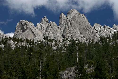
Greater Castle Crags
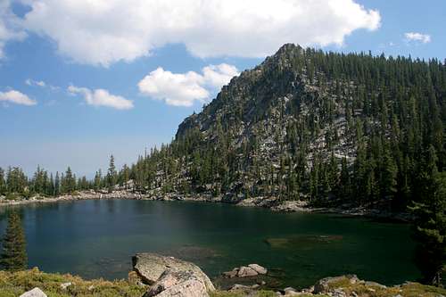
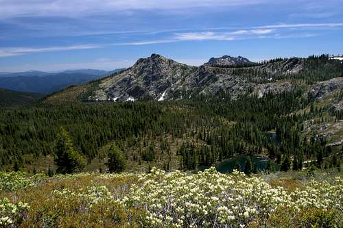 Boulder Peak, the Grey Rocks, and the Seven Lakes Basin
The central part of the Trinity Divide consists of a large east-west running ridge that culminates in the majestic Castle Crags. This ridge is a spur off of the main Divide crest. Although the highest point of the Crags is lower than most of the peaks in the Trinity Divide, their granite domes and spires are easily the most recognizable landmarks in the entire range. The Castle Crags take second place only to Mount Shasta as the regions most iconic landmark. Despite being well known, the Crags are barely used. The reason for this is that they are so rugged that only two trails lead hikers into the granite fastness. These trails, the Pacific Crest Trail and the Castle Dome Trail only skirt the periphery of the formation, which leaves the vast bulk of the Crags seldom seen.
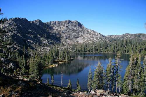
To the west of the Castle Crags the ridge connecting the granite formation to the main crest of the Trinity Divide climbs higher and has a series of attractive peaks and lake basins. Most notable of these is Castle Lake, which at 47 acres, is one of the largest lakes in the Klamath Mountains. The stark granite cliffs soar over 1,000 feet above the lake. A cluster of smaller lakes, including beautiful Heart Lake, nestled in the cliffs. Other significant lake basins include the Gray Rock Lakes, the Cliff Lake Basin and the Seven Lakes Basin. All together, the central portion of the Trinity Divide contains 20 named lakes and numerous unnamed lakes.
Castle Crags Wilderness
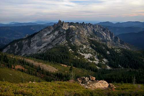 The Castle Crags as seen from Castle Peak
The small Castle Crags Wilderness is the only designated wilderness in the Trinity Divide. In addition to containing the bulk of the Castle Crags, the wilderness area also claims the Gray Rock Lakes Basin, the cliffs above Castle Lake, which includes Heart Lake and two peaks over 7,000 feet. Most of the use in the wilderness is focused on hiking and climbing in the Castle Crags and hiking above Castle Lake. The Pacific Crest Trail traverses the southern side of the wilderness. They Gray Rock Lakes see little use. More information on the wilderness can be found here:
Southern Divide
Paradoxically, the southern Trinity Divide is both the most used and yet unused portion of the range. The reason for this is a legacy of the areas logging and railroad history. During the 19th century the railroads were are allotted a checkerboard patterned array of sections interspersed between lands in the public domain. Today, these significant inholdings are still held in the midst of the national forest. Most of them have been sold to logging companies have been active in harvesting the timber. By a strange twist the activity of the logging companies has discouraged hikers from exploring the fantastic scenery contained in the sections that are intercalated with the private land. While it is unfortunate that such fantastic landscapes have gone completely unappreciated, it leaves some of Northern California’s best scenery to the few locals and hearty visitors to explore.
 Tamarack Lake in the southern Divide
Chief among the spectacles in this part of the Trinity Divide are the stately Grey Rocks. Few mountains in this part of the state are as lost and unappreciated as these twin summits. From towering peaks, plunging canyons and cliffs, extensive spring fed meadows and gorgeous lakes are the defining feature of these beautiful mountains. Just below the Grey Rocks is the Tamarack Lake Basin, which features some of the prettiest lakes of the range nestled below towering granite cliffs. Four other named lake basins are found in the southern Divide.
The southern Divide is a long crescent shaped crest running from the Grey Rocks in the northeast to the Red Mountain in the southwest. It is separated from the rest of the Divide by the 5,500 foot pass at Whalan Summit. South of Red Mountain there are no more lakes or peaks exceeding 6,000 feet, nor are there any more forks of either the Sacramento or Trinity Rivers. Indeed, a few miles south of the Divide the crest splits, forming the Clear Creek watershed, which does not join the Sacramento over 50 miles further to the south.
Bonanza King
 The southern end of the Divide: Red Mountain and Bonanza King
Situated between the main crest of Trinity Divide and the Trinity Alps, yet still on the east side of the Trinity River is Bonanza King, a massive granite massif that stands in isolation from all of the surrounding mountains. It is ambiguous where Bonanza King fits taxonomically, since it is not connected to the main crest of the Trinity Divide and lies between the main branch of the Trinity River and the East Fork of the Trinity River. While these are strong reasons for its exclusion from this page, it is being included because it still lies between the Sacramento and Trinity Rivers and connected to the rest of the Trinity Divide by a high, 5,000 foot pass. Moreover, unless one considered it a range unto itself, it would not have a home anywhere else on Summitpost other than the catchall Klamath Mountains page.
Outdoor enthusiasts seldom visit the mountain. Those who do are generally in search of the summit, since the peak is a California 2K prominence peak (actually a peak within the margin of error, but it still draws its share of climbers). This does not mean that there is no other use of the mountain. A prominent peak on the south shoulder of the mountain hosts a staffed lookout tower. As the name implies, there has also been significant mining activity on Bonanza King. The mountain has attractive granite crags. It is almost entirely dry, except for the diminutive Scorpion Lake, located on the west side below the lookout tower.
Trinity Divide: Watershed Divide / Regional Map
 The Trinity Divide watersheds
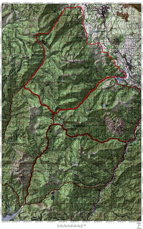
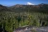
Mount Shasta and the Trinity Divide
 Mount Shasta and the Castle Crags from the Grey Rocks
One of the great features of exploring the Trinity Divide is the ubiquitous presence of THE mountain, Mount Shasta. Whether from the flanks of China Mountain in the north to the summit of the Grey Rocks in the south, Mount Shasta is an ever present companion to those hiking the trails and climbing the peaks of the Divide. Even from trails and peaks on the west side of the crest the mountain often looms large. The great volcano presents a different appearance depending where in the Divide one is. Prominent guidebook author Tom Stienstra believes that the view of Mount Shasta from the Castle Lake road, just below the campground, is one of the best "drive to" view points of the mountain. It is likely that he is right. With such an awesome spectacle presenting itself from all parts of the Trinity Divide, it is easy to see why the range is so often overlooked.
Mount Shasta Views
 |  |  |  |  |  |  |
 |  |  |  |  |  |  |
Waterfalls
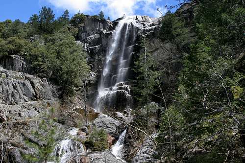 Burstarse Falls
Although it is not noted for its waterfalls, the Trinity Divide boasts several excellent cataracts. The most famous falls is Mossbrae Falls, near Dunsmuir. Although this waterfall is could considered a child of the Cascades, it presence on the Sacramento River, which is largely a Klamath Mountains river, lends weight to its association to the Trinity Divide.
Aside from Mossbrae, other great falls call the Divide home. The view of Root Creek Falls cascading below Castle Dome ought to be a much more iconic vista. Surprisingly this view remains largely unknown. Burstarse Falls, also in the Castle Crags is a great free fall accompanied by several subsequent cascades. Faery Falls, in nearby Ney Springs Canyon is perhaps the most easily reached waterfall in the Trinity Divide. The presence of historic ruins near the falls and the adjacent climbing area add interest to falls area.
Perhaps the most enigmatic falls in the Trinity Divide is the cataract on Wagon Creek, plunging down the east side of Mount Eddy. In the spring, this series of falls are prominently visible from the Mount Shasta City area, but the lack of trails and access add an air of mystery.
Pacific Crest Trail
 Porcupine Lake, on the PCT
The Pacific Crest Trail weaves its way 2,663 miles from California’s border with Mexico to just across Washington’s border with British Columbia in Canada. 37 of those miles pass through the Trinity Divide, covering some of the finest scenery in the range. Beginning at the Soda Creek exit on I-5, the trail climbs the Castle Creek drainage, climbing almost 4,500 in 23 miles to Gumboot Saddle, where it joins the main crest of the Trinity Divide. On this section of the trek, the PCT winds along the flanks of the Castle Crags and then traverses high above the Seven Lakes Basin. North of Gumboot Saddle, the trail passes below Porcupine Lake, above Toad Lake and through the Deadfall Lakes. It stays relatively level on this segment and ends at Parks Creek Pass, where the Trinity Divide begins to merge with the Scott Mountains.
Considering how many lakes and peaks one finds in the Trinity Divide, it is surprising that there are not more trails than there the range actually contains. Aside from neglect and a certain anonymity, one of the reasons there are not many trails is the the PCT is routed along many of the range's highlights, thereby negating the need for separate trails anywhere near the crest. The following are some of the destinations that can be reached easily via the PCT:
Seven Lakes Basin
Burstarse Falls
Porcupine and Toad Lakes
China Mountain
Also, the PCT is one of two routes that provides access to Deadfall Basin and Mount Eddy.
Rock Climbing
 Granite domes of the Castle Crags
Not surprisingly, most of the climbing in the Trinity Divide is centered on the Castle Crags. The vast complex of granite spires is just beginning to be tapped and unnumbered first ascents await the adventurous climber. Despite the surface just being scratched, there are several classic climbs established in the Crags, among them East Face Dike Route on Castle Dome and the Cosmic Wall on Mount Hubris. This area has high quality granite. Another well-developed climbing area is located just north of the Castle Crags at the mouth of Ney Springs Canyon. Although nothing like the scale of the Crags, it has the added bonus of generally being climbable even in mid-winter.
A good overview of climbing in the Trinity Divide, particularly at the Castle Crags and Ney Springs Canyon can be found here.
Camping
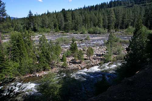 Dispersed camping is popular along this stretch of the Sacramento River
There are abundant campsites in the Trinity Divide. There are six established campgrounds. The two largest are located at Castle Crags State Park and at Lake Siskiyou. The state park also has a couple of walk in campsites (one of the six campgrounds). The Lake Siskiyou campground is a privately run full service camping area with showers and a store etc. There are also three small primitive campgrounds operated by the Forest Service located at Castle Lake, Gumboot Lake and Toad Lake.
In addition to the established campgrounds, there is a wealth of dispersed camping opportunities. This includes pretty much anywhere you can drive to in the National Forest that is not on a private in holding. Particularly popular areas include the entire length of South Fork Road once it enters the National Forest, the parking area at Castle Lake and along Castle Creek beginning at the western border of the state park. Mumbo Lake also offers great sites. Camping is allowed at nearly all the trailheads as well.
Access
Although most of the high country in the Klamath Mountains is roadless wilderness, the Trinity Divide present a rare opportunity to access the high country via three paved roads. These roads provide convenient access to trailheads and several lakes. In addition to making it easier to access the scenic parts of the range, they also present the opportunity for scenic drives for those not willing or unable to explore these mountains on foot.Parks Creek Road
This road crosses the northern Trinity Divide, connecting I-5 and the Shasta Valley to Highway 3 and the Trinity River Canyon. Three good trailheads are found on along this road. The first, when coming from the east, is for the Caldwell Lakes, a seldom-visited trio of lakes in a large cirque on China Mountain. The other trailhead is for the PCT at Parks Creek Pass. Going north, the PCT reaches Bluff Lake in 4.5 miles. Going south the PCT traverses the Trinity Divide crest and also provides access to the Deadfall Basin and Mount Eddy. Just past the PCT trailhead is the Deadfall Meadow trailhead, which links up to the PCT at Deadfall Basin.
South Fork Road / Castle Creek Loop
 Castle Spire and the west end of the Crags from Castle Creek Road
This is by far the most heavily used access to the Trinity Divide. The opportunity to drive a paved loop at higher elevations is an attractive option for many. The views of Mount Shasta, the Sacramento River, Trinity Alps, Grey Rocks and Castle Crags all make for a memorable drive. Those interested in more than driving will find many choices. In addition to recreating in the Sacramento along South Fork Road, the Gray Rock Lakes, Cliff Lake Basin, Gumboot Lakes, Seven Lakes Basin, Trinity Divide Crest (PCT), and the Mumbo Lakes are all accessed from the northern half of the loop. The southern leg of the trip provides access to the Tamarack Lake Basin and the Grey Rocks. The Castle Crags can be access from the either the Dog Trail or from Castle Crags State Park, at the southern end of the loop.
Castle Lake Road
The only dead end of the three paved roads in the Trinity Divide, Castle Lake ends at shores of its namesake lake. Most who drive up here swim or fish at the lake or make the hike up to Heart Lake, nestled high up in the cliffs above Castle Lake. Castle Peak, Little Castle Lake and Mount Bradley are all accessed from this trailhead.
Other Access Roads
Rough 4x4 roads access other areas in the Trinity Divide. Toad Lake, the Seven Lakes Basin, Tamarack Lake, Dobkins Lake and Morgan Meadow are all reached by dirt roads. Other, lesser known destinations are all accessible by this complex network of roads that blanket the lower reaches of the Divide.
Trinity Divide Access Map
 Map showing paved roads accessing the Trinity Divide
Getting There
 Cliff Lake, one of most accessible, yet least known, lakes in the Trinity Divide
Reaching the Trinity Divide is a simple proposition. Highway 3 parallels the range on its west side and I-5 follows its east side. Nearly all of its usage begins on the east side, as only the Parks Creek Road provides easy access from the west. Four exits off of I-5 provide quick access to the roads leading into the Trinity Divide. In the south, the Castella exit is the southern terminus for the South Fork / Castle Creek loop. One exit to the north, Soda Creek, is at the intersection of I-5 and the PCT. This is often used as an alternate route to climb Castle Dome and to continue north on the PCT. To reach South Fork Road and Castle Lake Road, take the Central Mount Shasta exit and head west. The Edgewood exit, north of Weed, connects to the road leading to Parks Creek Summit.
Red Tape
 Boulder Peak, Echo Lake and the Castle Crags
The biggest issue in the Trinity Divide is crossing the private inholdings. They are not necessarily avoided, as evidenced by the PCT crossing numerous private sections. The timber companies are generally ok with people on their land, provided they do not spend the night and cause any problems. Please be on your best behavior while on these areas in order to help keep them open.
A campfire permit is required.
While the Castle Crags Wilderness is the only official wilderness in the Trinity Divide, much of the land is de facto wilderness. Normal wilderness rules and ethics should be applied while in these areas.
Shasta-Trinity National Forest
3644 Avtech Parkway
Redding, CA 96002
(530) 226-2500
Mount Shasta Ranger Station
204 West Alma
Mt. Shasta, CA 96067
(530)926-4511
Additional Information
 Lower Caldwell Lake and Mount Shasta
Print Resources
There are no hiking guides that cover the Trinity Divide in its entirety. Numerous guides cover a smattering of hikes in different parts of the Divide. The two most thorough books are Selters and Zanger's Mount Shasta Book and Summitpost member Robin Kohn's Mount Shasta Guide to Fun
Maps
The usual USGS quads are available for the Trinity Divide. The Forest Service offers a map that has the Mount Shasta Wilderness on one side and the Castle Crags Wilderness on the reverse. This is the only part of the Trinity Divide that has a dedicated trail map devoted to it. It is high time that a complete trail map to the entire range be mad.
 Mount Eddy reflects in Lake Siskiyou
Logistical Centers
The communities of Mount Shasta, Weed, Dunsmuir and Castella are all found at the foot of the mountains. While all (except Castella) offer lodging and dining, the town of Mount Shasta is the most centrally located and offers the most amenities. Castle Lake the the South Fork / Castle Creek Loop are all accessed from town. Supplies are available at Ray's Food Place (off of Lake) and the Mount Shasta Market (on Alma). The town also has a full service hospital available for medical needs. The Forest Service ranger station is located on Alma.
Trinity Divide Sunset
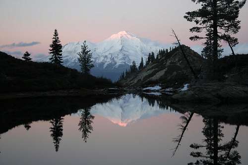 Mount Shasta from Heart Lake