
-
 4704 Hits
-
 82.48% Score
-
 15 Votes
|
|
Mountain/Rock |
|---|---|
|
|
41.18211°N / 122.5394°W |
|
|
Hiking, Scrambling |
|
|
Spring, Summer, Fall |
|
|
6779 ft / 2066 m |
|
|
Overview
 "South Mumbo Peak"
“South Mumbo Peak” is one of the westernmost mountains in the Trinity Divide. Only the massive Bonanza King is further to the west. Indeed, “South Mumbo Peak” is one of the few peaks that actually lie on the west side of the Divide crest. The peak, unofficially unnamed, is little known and rarely climbed, being generally overshadowed by nearby peaks that are higher, boast lakes on their flanks, and are closer (albeit by short distances) to the communities around Mount Shasta. Nonetheless, the peak makes for a quick and worthy outing while driving the South Fork-Castle Creek Loop, one of the paved roads that penetrate the Trinity Divide’s high country. A short scramble yields great views of Mount Shasta, Mount Eddy and the Grey Rocks as well as a rare opportunity to view the western side of the Trinity Divide, a mountain range that is almost exclusively viewed from the east (the great exception to this is the view of the Divide from the rarely climbed peaks on the eastern fringe of the Trinity Alps), as well as a grand view of the Trinity Alps. The peak is one of the easier peaks to summit in the Trinity Divide. This alone, plus the relative ease of access, make it a mountain that deserves more attention than it currently receives.
 Looking north from "South Mumbo Peak"
The Trinity Divide is a north to south trending range that stretches 20 miles from China Mountain in the north to Red Mountain in the south. The range is so named because it constitutes the divide between the Trinity River and Sacramento River watersheds. A small section at the northeast end of the divide, north of Mount Eddy contributes waters to the Shasta River. Most of the peaks in the range are found along the crest or on the massive rib that extends east from the center of the Divide and culminates in the magnificent Castle Crags. Only a handful of peaks are found on the west side of the Divide. “South Mumbo Peak” is one of these few summits. Consequently, it is entirely within the Trinity River watershed. One of the largest, early tributaries of the Trinity River, Mumbo Creek, forms on the north side of the mountain. The peak is the southern verge of Mumbo Basin, a large, forested bowl that has extensive meadows. The Mumbo Lakes are at the head of the basin, just east of “South Mumbo Peak”. Mumbo Peak composes the northern boundary of Mumbo Basin.
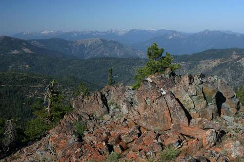 The Trinity Alps from "South Mumbo Peak".
Like much of the Trinity Divide, “South Mumbo Peak” is composed primarily of serpentine, a greenish-blue rock (the state mineral of California) that is the raw form of asbestos. Peridotite, greenstone, and granitic rocks are found along the crest of the mountain. Like most of the peaks in the Trinity Divide, “South Mumbo Peak” has forested southern slopes and a craggy northern aspect. Though not as rugged as many of the other peaks in the Divide, the bare rock face of “South Mumbo’s” maintains an attractive appearance. There appear to be two glacial cirques carved into the northern face, complete with what seem to be small moraines. Though unconfirmed, this conforms to the general pattern of peaks in the Trinity Divide, which generally have forested southern slopes, craggy northern faces that preside over glacial lake basins. “South Mumbo Peak” even has a small pond in place of a lake in the larger cirque. Despite not having significant lakes, both cirques still boast attractive meadows that are filled with large fields of yellow lupines.
As previously stated, there are excellent views from “South Mumbo Peak”. While the summit does offer good perspectives, the best are from a shoulder just north of the summit. This is due to the lack of trees obscuring the views. The Scott Mountains, northern Divide, including Mount Eddy, Mount Shasta, the southern Divide and Bonanza King are all part of the viewshed from the north shoulder of “South Mumbo Peak”. Perhaps the most impressive view, though, is to the west, where the Trinity Alps loom darkly, only 8 miles to the west, across the Trinity River’s upper canyon. Rank upon rank of dark, jagged peaks spread out into the western horizon. So good are the views from the vantage of “South Mumbo Peak” that is frequently used as a volcano observation site, which is at once reassuring and disturbing.
 The Grey Rocks from "South Mumbo Peak".
"South Mumbo Peak" Area Map
 Mumbo Basin area
Route
 The larger cirque below the summit
From the pullout on road 38N55, there is an obvious route up the side of the mountain. As one progresses, the path gets narrower and ultimately fades as it leaves the forest. From here, the slopes are generally naked rock with patches of low brush. It is easy to pick ones way through the brush to the rocky shoulder of "South Mumbo Peak". This shoulder is used as the volcano observation point. From the shoulder, continue west to the edge of a saddle that separates the shoulder from the summit. One simply heads down the saddle and makes the short, steep climb up to the summit of “South Mumbo Peak”. For the best views, continue north from the summit. The route drops down another slope to a ridgeline that leads to the shoulder vista point. The ridge traverse is the most attractive part of the trip, with great views in all directions, wildflowers and pleasant hiking. From the shoulder, simply retrace ones steps. A shortcut back to the parking area heads southeast from the saddle between the summit and volcano observation point. The terrain through this stretch is generally open, but does require a small amount of bushwhacking.
Route Map
 "South Mumbo Peak" map
Getting There
 "South Mumbo Peak" from the South Fork-Castle Creek loop
From the town of Mt. Shasta, head west on W. Lake, crossing over I-5. At the stop sign, turn left onto Old Stage Road. After 0.25 miles, veer right onto WA Barr Road. Continue south, crossing over the dam that impounds the Sacramento River and forms Lake Siskiyou. At the intersection with Castle Lake Road, stay straight. The road becomes Forest Road 26. Follow this road for nearly 12 miles. A signed fork indicates Gumboot Lake is 0.5 miles to the left. Continue to the right, climbing up the cirque that contains the Gumboot Lakes. The PCT Gumboot Trailhead is located at the summit. From the Gumboot Trailhead, continue driving for another 2.3 miles to the intersection with road 38N55. Head west on this dirt road for 0.5 miles to a wide section with an obvious use-trail heading off the south.
Red Tape
 Mount Shasta seen from "South Mumbo Peak"
While “South Mumbo Peak” is surrounded by public land, the peak itself is privately owned by Sierra Pacific. Inholdings held by timber companies are common in the Trinity Divide and access is generally not forbidden, though camping is strictly verboten. Although privately owned and lacking any sort of wilderness protection, the mountain is still in an essentially wild state, rarely traveled beyond the volcano observation point. Wilderness rules and ethics should be applied strenuously, to keep the area open.
Shasta-Trinity National Forest
3644 Avtech Parkway
Redding, CA 96002
(530) 226-2500
Mount Shasta Ranger Station
204 West Alma
Mt. Shasta, CA 96067
(530)926-4511