
-
 25742 Hits
-
 96.25% Score
-
 58 Votes
|
|
Mountain/Rock |
|---|---|
|
|
48.78743°N / 113.68568°W |
|
|
Hiking, Mountaineering |
|
|
Summer, Fall |
|
|
7600 ft / 2316 m |
|
|
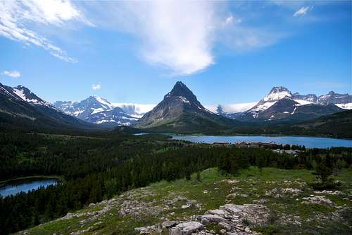
Overview
 Welcome to Many Glacier! Grinnell Point (center) sits amongst a sea of towering peaks.
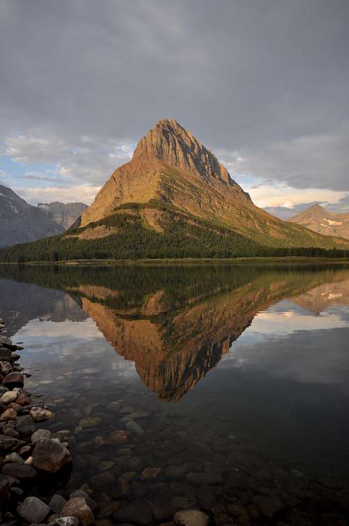
Grinnell Point is, simply, an arbitrary point near the easternmost extension of Mount Grinnell's long summit ridge. It rises so abruptly and so prominently that from Swiftcurrent Lake, it totally obliterates any view of the much larger Mount Grinnell, which tops out at an elevation of 8,851 feet, over 1,200 feet higher. It's a rather confusing summit, as the large cairn that marks most climber's final destination is actually much lower than many points farther to the west. In fact, many people en route to the point accidentally climb one of the many taller spires along the summit ridge; fortunately, it's easy to down climb slightly and traverse eastward to the accepted summit. Like many geographical features of Many Glacier, it is named after George Bird Grinnell, naturalist, writer, and early proponent of protecting the magnificent stretch of the Rocky Mountains now known as Glacier National Park. Note that it was previously known as "Stark Peak," a very fitting and descriptive name for this Many Glacier landmark (1).
![Many Glacier Valley]()
A somewhat more familiar perspective of Grinnell Point, rising high over Many Glacier Hotel on the opposite shore of Swiftcurrent Lake.
![Swiftcurrent Lake]()
from the north shore of Swiftcurrent LakeMany Glacier can also be accessed via several well-maintained trails. The Highline Trail passes Granite Park Chalet, and detouring east over the Continental Divide on the Swiftcurrent Pass Trail will bring hikers to Many Glacier. The spectacular Piegan Pass Trail, which originates at Siyeh Bend east of Logan Pass on Going-to-the-Sun Road, ends along the shores of Swiftcurrent Lake right next to the Many Glacier Hotel. Hikers coming in from the Belly River Valley can also climb up the steep trail through Ptarmigan Tunnel, which terminates at the Swiftcurrent Motor Inn.
Most parties looking to climb Grinnell Point will start their day at one of two trailheads for the popular Swiftcurrent Nature Trail. A trailhead is located immediately south of Many Glacier Hotel, with the other originating from the opposite side of Swiftcurrent Lake at the Grinnell Glacier Picnic Area. It really doesn't matter where you start; from both trailheads, it is almost identical distance to the bifurcation which leads towars the North Shore Lake Josephine Trail.
Another viable access point is from the Swiftcurrent Pass Trail, located at the west end of the parking lot for the Swiftcurrent Motor Inn. Technical ascents of the north face can begin here, and those looking to climb Mount Grinnell and descend to the long connecting ridge towards Grinnell Point may chose to start from this trailhead.
![South Ramp Route]()
South Ramp Route. Click on the photo for a detailed route description.
Based on my experience, this route is far and away the most popular way to climb this peak. Total elevation gain is 2,700 feet, and most parties will be able to complete the round-trip climb in no more than six to eight hours. Start off on the nature trail that circles Swiftcurrent Lake and follow signs to the North Shore Lake Josephine Trail. As the trail begins to wind around Josephine, you'll pass a small pond below the trail to the left that holds large chunks of ice well into the summer months. Shortly thereafter, take note of a steep 20-foot tall cliff that overhangs the trail on the right. Once past the cliff, the trail passes through a short stretch of forest. After breaking out of the trees, study the very large, sheer cliff that rises a few hundred feet high above the trail to the right. Edwards refers to a "great waterfall" that tumbles over this cliff; however, the waterfall is not as grand as it once was, for the water that makes its way over the cliff is often reduced to a mere trickle. Still, the cliff is usually quite wet and appears very dark, and as such is easily distinguishable from the Josephine Trail. Leave the trail once directly beneath the cliff, and plod straight uphill through sparse vegetation. This is prime grizzly bear habitat, and sows with cubs are regularly viewed in this area. Make TONS of noise and stay close to your climbing partners while ascending this hillside to avoid any surprise encounters!
![Wet Cliff on Grinnell Point]()
The large wet cliff![The Grassy Ramp]()
The Grassy Ramp on loose ledges until reaching the base of a tremendous cliff. By traversing across the top of the couloir to the south, an obvious game trail will be located. It climbs up a broad grassy ramp and passes to the right of a peculiar dead tree which sits perched on the edge of a drop off of several hundred feet.
![Grinnell Point Outcropping]()
This red outcropping must be climbedA massive snow chute leads steeply uphill from the mine. The route meanders uphill along the snow chute for the next 1,000 vertical feet. At times the route will be rather close to the snow, which allows for mesmerizing views down to Lake Josephine. At other times, the path of least resistance may take you 100-200 feet to the right, where impassable, towering cliffs border the other side of the route. It is not uncommon for parties to find themselves cliffed out at times; if so, simply retrace your steps and remember that nothing worse than Class III need be climbed with care in route finding. The crux move of the upper portion of the route involves identifying a prominent red outcropping, no more than 12 or 15 feet high, that sits separated from a cliff near the snow chute. A nearby frightening 20-30 foot cliff will force parties to realize that utilizing the outcropping is really the only viable option for a continued safe ascent. Fortunately, the outcropping can be climbed on the north side, which avoids any serious exposure, and has good hand and foot holds. Near the top of the outcropping, it is necessary to either jump or stem across to higher ground. Above this point, the going becomes easier. A large scree field is reached, and the top of the snow chute and the summit ridge is visible. Avoid the temptation to climb to the ridgetop; Grinnell Point is NOT the actual highpoint on the ridge, but rather is further out to the east. (Note that it is possible to gain the ridgetop from this spot; a loose gully leads to a spectacular notch between two pillars on the ridge. To reach the summit cairn, you will have to descend slightly and traverse eastward on skinny ledges, or retrace your steps and walk beneath tall cliffs.) Instead, look for trails that cut through the scree beneath impressive green lichen-colored cliffs that reach up to the skyline. Soon after, you should be able to notice the impressively large summit cairn, and a short scramble through an easy break will lead you to Grinnell Point. Enjoy the incredible views from the top.
Additional Routes for Grinnell Point

A somewhat more familiar perspective of Grinnell Point, rising high over Many Glacier Hotel on the opposite shore of Swiftcurrent Lake.
Getting There
Grinnell Point is located in the Many Glacier Valley in the northeastern sector of Glacier National Park. It rises abruptly across Swiftcurrent Lake from the famed Many Glacier Hotel, which is accessed from US-89 via the small, unincorporated town of Babb, MT. A paved, pothole ridden road winds 12 miles from Babb to its terminus one mile past the hotel at the Swiftcurrent Motor Inn; this is the only way to enter Many Glacier via automobile. Babb is located 8 miles north of St. Mary, a small, busy tourist village at the east entrance of Going-to-the-Sun Road, and 11 miles south of the US-Canadian border crossing at the Port of Piegan in Carway, Alberta.
from the north shore of Swiftcurrent Lake
Most parties looking to climb Grinnell Point will start their day at one of two trailheads for the popular Swiftcurrent Nature Trail. A trailhead is located immediately south of Many Glacier Hotel, with the other originating from the opposite side of Swiftcurrent Lake at the Grinnell Glacier Picnic Area. It really doesn't matter where you start; from both trailheads, it is almost identical distance to the bifurcation which leads towars the North Shore Lake Josephine Trail.
Another viable access point is from the Swiftcurrent Pass Trail, located at the west end of the parking lot for the Swiftcurrent Motor Inn. Technical ascents of the north face can begin here, and those looking to climb Mount Grinnell and descend to the long connecting ridge towards Grinnell Point may chose to start from this trailhead.
Route Information
South Ramp Route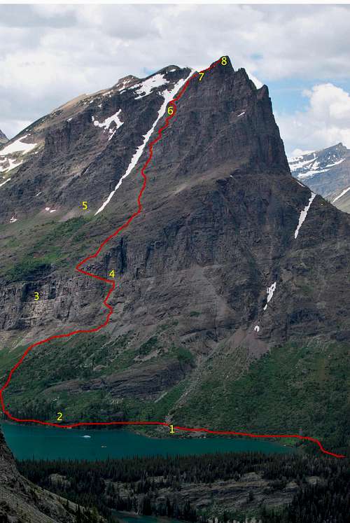
South Ramp Route. Click on the photo for a detailed route description.
Gordon Edwards' classic A Climber's Guide to Glacier National Park outlines several routes up this fantastic spire, ranging from class III scrambling all the way up to a class V technical endeavor. All routes covered on this page were previously documented by Edwards, and I highly recommend obtaining a copy prior to attempting to summit Grinnell Point (2).
Based on my experience, this route is far and away the most popular way to climb this peak. Total elevation gain is 2,700 feet, and most parties will be able to complete the round-trip climb in no more than six to eight hours. Start off on the nature trail that circles Swiftcurrent Lake and follow signs to the North Shore Lake Josephine Trail. As the trail begins to wind around Josephine, you'll pass a small pond below the trail to the left that holds large chunks of ice well into the summer months. Shortly thereafter, take note of a steep 20-foot tall cliff that overhangs the trail on the right. Once past the cliff, the trail passes through a short stretch of forest. After breaking out of the trees, study the very large, sheer cliff that rises a few hundred feet high above the trail to the right. Edwards refers to a "great waterfall" that tumbles over this cliff; however, the waterfall is not as grand as it once was, for the water that makes its way over the cliff is often reduced to a mere trickle. Still, the cliff is usually quite wet and appears very dark, and as such is easily distinguishable from the Josephine Trail. Leave the trail once directly beneath the cliff, and plod straight uphill through sparse vegetation. This is prime grizzly bear habitat, and sows with cubs are regularly viewed in this area. Make TONS of noise and stay close to your climbing partners while ascending this hillside to avoid any surprise encounters!
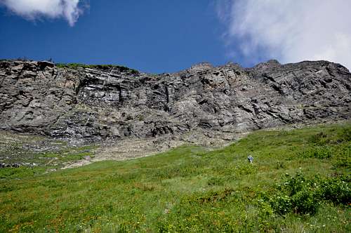
The large wet cliff
As the large wet cliff is approached, traverse to the right (north) along its base for a few hundred feet until reaching a broad class III couloir. Extreme care must be taken in selecting the safest route to access the couloir. In July of 2013, a climber fell at least 60 feet to this death while climbing a very steep rock face immediately below the couloir. When in doubt, keep traversing to the right (north) to find the easiest break in the cliff band. Scramble upwards
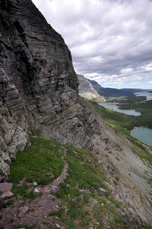
The Grassy Ramp
Above the ramp, the game trail continues south towards a small drainage (which continues downhill and over the aforementioned wet cliff). It is possible to continue in this direction, but ultimately the game trail will become difficult to follow and you will be forced to scramble uphill on steep, brush-covered cliffs. A better option is to leave the game trail above the grassy ramp and head uphill and to the right. Small cliff bands will be encountered, but can be safely bypassed by generally trending to the right (north). Eventually, you will encounter a very well-worn game trail cuts through the scree above the cliffs. Following it to the northeast (right) will lead to an impressive overlook of Many Glacier Hotel, whereas following the trail downhill (southwest) leads to the defunct Josephine Mine, which is marked by a distinct pile of fine grey rock at its entrance.
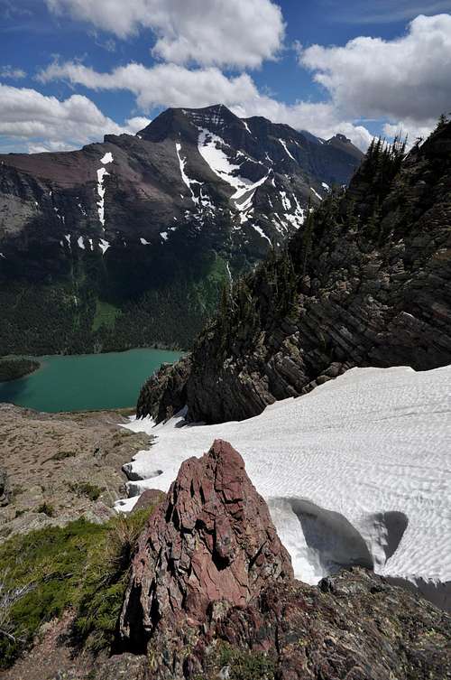
This red outcropping must be climbed
 |  |  |  |
|---|
Additional Routes for Grinnell Point
*** I personally have not attempted the following routes, but they are outlined in detail in the Edwards' guide. His route descriptions are fantastic, and he includes a very helpful hand drawn diagram that should aid anyone looking to successfully climb Grinnell Point. The Miner's Trail and East Ridge routes have different approaches than the South Ramp Route, but ultimately lead to the Josephine Mine, upon where the great snow chute can be followed all the way to the top.
The Miner's Trail Route
An old trail used to branch off the Grinnell Glacier Trail back towards the east, and climbed steadily towards the Josephine Mine. According to Gordon Edwards, it was quite common for ranger-naturalists to lead hiking groups to the mine via this route. I believe the old trail can be found at the easternmost point of the first switchback about half way along the Grinnell Glacier Trail.
East Ridge Route
This route involves bushwhacking up a round, forested hump that rises towards Grinnell Point from the southwest corner of Swiftcurrent Lake. Some class III and IV stretches are likely to be encountered. The route eventually meets up with the prominent game trail that heads southwest brings you to the Josephine Mine and the bottom of the great snow chute.
Traverse from Mount Grinnell
If you are looking for a long, exciting day far above the treeline, it's possible to walk the long ridge between Mount Grinnell and Grinnell Point. From the summit of Mount Grinnell, descend towards the east via 2,000 feet of scree. From there, the ridge leading to Grinnell Point can be easily traversed. There are a couple of cliff bands and humps along the ridge that will likely need to be bypassed.
North Face Route
Multiple pitches involving crack climbing, and one sixty foot high chimney. Technical rock climbing equipment and skills required. I'd consider inquiring at the Many Glacier Ranger Station for further details.
![a different perspective of Grinnell Point]()
Grinnell Point in April. That's a lotta snow!Due to extreme winters along the Continental Divide, problematic snow can linger on trails and mountain slopes well into July and August. Hence, the prime climbing season in Glacier is rather short, often beginning in June and lasting into late September/early October. However, some lower peaks and south facing slopes can be safely attempted much earlier in the season. Your best best is to inquire locally about snowpack and weather conditions. Personally, I have found the NOAA website to be the most reliable resource for detailed weather forecasts and snowpack information for the greater Glacier area.
Snow may linger on the grassy ramp that provides access to the area beneath Josephine Mine well into June. This ramp is somewhat north-facing, and could hold snow longer into the season. The rest of southeast slope is subject to ample sunlight, and although snow sticks to the prominent chute year-round, the class III terrain from the Joesphine Mine to the summit ridge may be devoid of snow in early June. This route is partially visible from a couple vantage points along the South Shore Lake Josephine Trail, as well as the flanks of Allen Mountain above Stump Lake and from the parking lot above Many Glacier Hotel; if you are looking to attempt a climb early in the season, I recommend scouting it out from either of these vantage points. Or check in with the rangers or staff at Many Glacier Hotel. Someone will hopefully be able to give you some insight on to whether or not the route is easily passable. From personal experience, I have climbed the South Ramp route as early as June 14, 2010; on this particular trip, we encountered zero snow the entire way.
The Miner's Trail Route
An old trail used to branch off the Grinnell Glacier Trail back towards the east, and climbed steadily towards the Josephine Mine. According to Gordon Edwards, it was quite common for ranger-naturalists to lead hiking groups to the mine via this route. I believe the old trail can be found at the easternmost point of the first switchback about half way along the Grinnell Glacier Trail.
East Ridge Route
This route involves bushwhacking up a round, forested hump that rises towards Grinnell Point from the southwest corner of Swiftcurrent Lake. Some class III and IV stretches are likely to be encountered. The route eventually meets up with the prominent game trail that heads southwest brings you to the Josephine Mine and the bottom of the great snow chute.
Traverse from Mount Grinnell
If you are looking for a long, exciting day far above the treeline, it's possible to walk the long ridge between Mount Grinnell and Grinnell Point. From the summit of Mount Grinnell, descend towards the east via 2,000 feet of scree. From there, the ridge leading to Grinnell Point can be easily traversed. There are a couple of cliff bands and humps along the ridge that will likely need to be bypassed.
North Face Route
Multiple pitches involving crack climbing, and one sixty foot high chimney. Technical rock climbing equipment and skills required. I'd consider inquiring at the Many Glacier Ranger Station for further details.
When to Climb
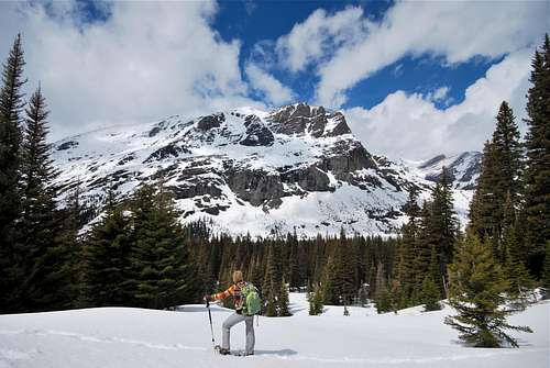
Grinnell Point in April. That's a lotta snow!
Snow may linger on the grassy ramp that provides access to the area beneath Josephine Mine well into June. This ramp is somewhat north-facing, and could hold snow longer into the season. The rest of southeast slope is subject to ample sunlight, and although snow sticks to the prominent chute year-round, the class III terrain from the Joesphine Mine to the summit ridge may be devoid of snow in early June. This route is partially visible from a couple vantage points along the South Shore Lake Josephine Trail, as well as the flanks of Allen Mountain above Stump Lake and from the parking lot above Many Glacier Hotel; if you are looking to attempt a climb early in the season, I recommend scouting it out from either of these vantage points. Or check in with the rangers or staff at Many Glacier Hotel. Someone will hopefully be able to give you some insight on to whether or not the route is easily passable. From personal experience, I have climbed the South Ramp route as early as June 14, 2010; on this particular trip, we encountered zero snow the entire way.
Grinnell Point would not be the best place to get caught in one of Glacier's afternoon thunderstorms. The terrain is extremely steep, and with numerous class III moves required, negotiating any routes in wet conditions could prove to be extremely hazardous. Make sure to check the weather before setting out and be cognizant of potentially threatening weather.
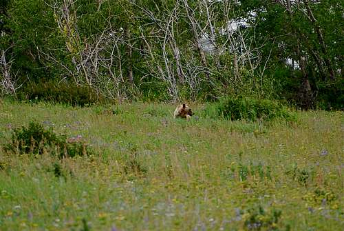
![grizzly bear off Many Glacier Road]()
Hey bear!Wildlife
![Grinnell Point, morning]()
Grinnell Point, morningOn July 25, 2013, 21 year old Matthew Needham from Simi Valley, California, fell to his death while attempting to climb Grinnell Point. He was an employee of Many Glacier Hotel and was climbing with experienced partners. This tragic event serves to remind us that climbing in Glacier National Park is dangerous, and can be potentially deadly. Even though this route is no more than 2 miles from the hotel he called home for the summer, danger lurks around every corner in Glacier. Remember to climb safely out there. Rest in peace Matthew.
Climber Dies from Fall Near Grinnell Point
Where to Stay
The fantastic Many Glacier car campground is located at the terminus of the Many Glacier Entrance road, one mile past the Many Glacier Hotel. The campground has 109 sites and as of November 2016 fees are $23 per night. Be forewarned: describing Many Glacier Campground as busy in the summer months is nothing short of an understatement. From mid-June to Labor Day, the campground almost universally fills well before noon. As of 2016, the NPS has implemented a reservation system and half the sites are reservable in advance. The remaining sites are available on a first-come, first-serve basis only. If you do not have a reservation, I recommend arriving before 7am to line up in the queue of walk-up campers. Information on historic campground fill times, reservations and camping regulations can be found on the NPS camping webpage.
Many Glacier Hotel offers 215 rustic rooms in a spectacular setting on the eastern shore of Swiftcurrent Lake. The hotel turned 100 in 2015, and does not have many modern amenities. It is extremely busy during the summer, and the concessioner recommends booking several months in advance. Rates range from approximately $150 to nearly $300 per night, with the majority of rooms in the $200 range. Visit Xanterra’s website for more information. There are also numerous local lodging opportunities (campgrounds, motels, cabins) just outside the park in and around the small towns of Babb and St. Mary.
Red Tape, Wildlife, Safety, etc.
Entrance Fees
A fee is required for all persons entering Glacier National Park. As of November 2016, single vehicle rates are $30 for a seven day pass, or $45 for an annual park pass (increasing to $50 in January 2017). A lower fee is charged for hikers and bikers; please visit the NPS fees webpage for a full explanation of the entrance fees.
Seasonal Closures
Glacier is subject to extreme winter weather conditions, and as such, much of the park is virtually inaccessible for the majority of the year. The Going-to-the-Sun Road is typically open in its entirety from mid-June to mid-September, and many of the developed areas of the park (including the historic lodges and most of the campgrounds) operate for a short window as well. Information on the operational status of front country campgrounds and park roads can be found by clicking on the hyperlinks.
Glacier Rock Grading
Due to the sedimentary nature of the rock in Glacier National Park, unique rock grading systems have been established by both Gordon Edwards and the Glacier Mountaineering Society. Please refer to the Glacier National Park Rock & Grading Systems Summitpost page (authored by Fred Spicker and Saintgrizzly) or the website of the Glacier Mountaineering Society for detailed information. If you are new to climbing in Glacier, I highly recommend checking out this info before attempting any climbs in the park. Oh, and don't forget to wear your climbing helmet!
A Climber's Guide to Glacier National Park
Pick up a copy of Gordon Edwards' classic A Climber's Guide to Glacier National Park. It's an absolute must for anyone who wants to safely venture to one of the park's many accessible mountain summits. Edwards spent many years as a seasonal ranger in Glacier, where he developed a deep passion for exploring the park's mountains and sharing its splendors with others. The book provides a fantastic history of climbing in Glacier, and his detailed and colorful route descriptions are a fantastic introduction to off-trail hiking and climbing in the park.
Hey bear!
The park is home to lots of potentially dangerous wildlife, including moose, black bear, grizzly bear, and mountain lion. Hike loud, carry bear deterrent spray (and know how to use it!), check local trail postings (for area warnings/closures) and let someone know your intinerary before heading out into the park. Also, note that special precautions are in place in all front and back country campgrounds to limit human-bear encounters. Regulations are posted everywhere (picnic tables, ranger stations, bathrooms) and it is every visitor's responsibility to take them seriously. Remember, a FED BEAR IS A DEAD BEAR! Please visit the NPS camping webpage for more detailed information.
Tribute and a Final Word of Caution
Grinnell Point, morning
Climber Dies from Fall Near Grinnell Point
External Links
Visit the FANTASTIC Glacier National Park page, a labor of love by late Summitpost member Saintgrizzly (R.I.P.), or the NPS webpage for more detailed information on "The Crown of the Continent".
References
1. Through the Years in Glacier National Park: An Administrative History, Appendix A, Historic Place Names. (2004, January 15). Retrieved January 02, 2017, from https://www.nps.gov/parkhistory/online_books/glac/appa.htm
2. Edwards, J. (1995). A Climber's Guide to Glacier National Park (1st edition published in 1961). Helena, MT: Falcon Press Publishing Co., Inc.
Parting Shots...
Since Grinnell Point is arguably one of the most photogenic peaks in the entire park, I'll end the page with a few more photos that try to capture some of its splendor... |  |
|---|
 |  |  |
|---|