
-
 6449 Hits
-
 78.27% Score
-
 9 Votes
|
|
Mountain/Rock |
|---|---|
|
|
47.55996°N / 12.25237°E |
|
|
Sport Climbing |
|
|
Spring, Summer, Fall |
|
|
6821 ft / 2079 m |
|
|
Overview
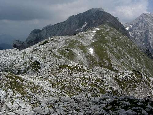
 Southern view of Hackenköpfe
The western part of Wilder Kaiser range consists of a single 5 km long ridge starting at Sonneck in the east and running straight west. The higher rock parts of that ridge are ending at Scheffauer and Zettenkaiser, the ridge then drops down to the gentle meadows of Walleralm.
Scheffauer is the best known and the most crowded summit of that ridge. East of Scheffauer and west of Wiesberg, a large alpine meadow below Sonneck and Kopfkraxen, you may recognise several not very prominent peaks sticking out of the connecting ridge with impressive rockfaces to the south and north. The whole terrain looks rather difficult and repellent.
These peaks are called Hackenköpfe and to my astonishment many years ago, when I considered a guide book of Wilder Kaiser, the traverse of these peaks is not exceeding UIAA grade II, mostly easier. The steep and often perpendicular rockfaces, however, are the world of the skilled climbers.
Hackenköpfe are a triple summit:
The connecting ridge from Scheffauer to Wiesberg is about 3 km long, quite a distance.
When I climbed the Hackenköpfe first in 1992 I met nobody. Scheffauer was crowded as usual and there were some parties climbing Sonneck. I returned in 1998 and it was the same. In 2010, however, I had to learn that Hackenköpfe traverse is no longer an insider tip. If you google Hackenköpfe, you know why ……
Nevertheless you will not meet too many people there.
Getting There
 Trailhead overview
Hackenköpfe are best summited from the south; trailheads for hikers and climbers are:
The best northern trailheads are:
Southern main trailheads
 Southern trail to Kopfkraxen
Northern main trailheads
For the northern trailhead you have to go to Kufstein.
Route Overview
Normal Route
The normal route of Hackenköpfe is the traverse of the three summits. You may climb Westlicher Hackenkopf together with Scheffauer and then turn back. But the traverse is such a great undertaking you should not miss it.
The traverse can be done west – east or east – west. Starting at the west end you pass the most difficult part of the traverse after a 3 minutes walk, an early test wether to go on or not.
 South ascent to Scheffauer South ascent to Scheffauer | 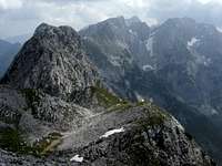 Hackenköpfe as seen from Scheffauer Hackenköpfe as seen from Scheffauer |  First chimney, the crux (UIAA grade II) First chimney, the crux (UIAA grade II) |
West end of the traverse
Col between Scheffauer and Westlicher Hackenkopf.
This col is the end point of:
East end of the traverse
West ridge of Kopfkraxen summit; trail junction of the Hackenköpfe traverse with trail Scheffau – Kopfkraxen – Hinterbärenbad.
You reach this end point using:
Traverse from west to east
Start at the col between Scheffauer and Westlicher Hackenkopf climbing the meadow east of that col. Follow the sharp ridge descending to a notch. Climb the steep chimney (UIAA grade II) back to the ridge and follow the ridge up to Westlicher Hackenkopf (easy rock scramble, cairn at summit).
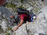 First chimney, the crux (UIAA grade II) First chimney, the crux (UIAA grade II) |  Mittlerer Hackenkopf as seen from Westlicher Hackenkopf Mittlerer Hackenkopf as seen from Westlicher Hackenkopf |  Westlicher Hackenkopf as seen from the east Westlicher Hackenkopf as seen from the east |
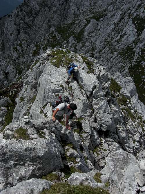
The ridge stays level first and then descends to a col between Westlicher and Mittlerer Hackenkopf. Follow the exposed ridge (easy scrambling) and descend on easy rock and meadows to the col (many karst features). Ascend again (UIAA grade I), follow the next level part of the ridge until it gets steep (summit block of Mittlerer Hackenkopf). Traverse into the southwest side to a notch (cairn) and follow some meadow and rock ledges (again cairns) to a broad chute directly below Mittlerer Hackenkopf.
Ascend that chute (UIAA grade I) until you reach a steep part; to your right there is a chimney (UIAA grade II), climb that chimney, leave it at its top to the left and traverse up to a notch in the main ridge. Descend some meters down the northeast side (cairn) and ascend through another chute up to the summit ridge of Mittlerer Hackenkopf (UIAA grade I).
Mittlerer Hackenkopf is in fact two summits, each with a huge cairn. Pass the first summit, follow the exposed ridge and traverse the second summit on its northeastern side and gain the ridge again.
 Route to Mittlerer Hackenkopf Route to Mittlerer Hackenkopf | 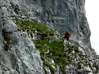 Looking up to Mittlerer Hackenkopf Looking up to Mittlerer Hackenkopf |  Mittlerer Hackenkopf chimney Mittlerer Hackenkopf chimney |
The ridge is now broad with meadows, limestone outcrops and many karst features. Follow the ridge in some ups and downs and with some short and surprising scrambling action (some UIAA grade I parts), pass some large dolines and ascend steadily to the culmination point: Östlicher Hackenkopf. The route traverses the summit on its south side until it gains the ridge; for the summit go back some steps on the ridge to lay a hand on the huge cairn on the top.
Now the route descends to Wiesberg, mainly on the south side of the ridge, in many ups and downs with meadow ledges, scrambling parts and again many karst features. There are several route possibilities on or just below the ridge line.
Arriving at the lower meadows of Wiesberg you have to stay left. Follow the meadows up, left of a little valley, following sparse cairns until the ridge gets sharp again and the route reaches the eastern end (or starting) point of the traverse where the southern ascent to Kopfkraxen and Sonneck reaches the ridge line.
Scheffauer (from the west end of the traverse), Kopfkraxen and Sonneck (both from the east end of the traverse) can be summited easily; allow 20 more minutes for Scheffauer and 1 to 1,5 more hours for Kopfkraxen and Sonneck (forth and back).
Climbing routes
Both, the northern and the southern rockfaces of Hackenköpfe are hosting some interesting climbing routes up to UIAA grade VII.
This page with many detailed information gives a first overview:
Hackenköpfe climbing routes overview
Red Tape & Accommodation
 Kaiser Hochalm, Wiesberg and Sonnenstein
The whole of Kaisergebirge is a nature protection area. Animals and plants are strictly protected.
Restrictions of other acticities, like camping out inside the protected area, fires, littering and so on are most likely; unfortunately there is no restriction list on the above mentioned homepage.
All sorts of accommodation can be found at:
Mountain huts and inns:
South side:
North side:
Gear & Mountain Conditions
 Scrambling on the traverse below Mittlerer Hackenkopf
Hackenköpfe are (late) spring, summer and autumn summits.
For the traverse you need to master UIAA grade II in exposed terrain; the route then normally needs no belaying.
As there are not many cairns you sometimes need the skills to find the best route. Full hiking gear is needed for the traverse.
All the climbing routes need full climbing gear and are exclusively for the good climbers among us.
Current Weather
Check the weather forecast here.
Map & Guide Books
 Wiesberg, Kopfkraxen and Sonneck
Map
Alpenvereinskarte, scale 1 : 25.000
Kaisergebirge, Blatt 8
Guide Books
Pit Schubert
Kaisergebirge Alpenvereinsführer extrem
edition 2000
Bergverlag Rother
Horst Höfler / Jan Piepenstock
Kaisergebirge Alpenvereinsführer alpin
12. edition 2006
Bergverlag Rother