|
|
Mountain/Rock |
|---|---|
|
|
47.60871°N / 12.24255°E |
|
|
Hiking, Mountaineering |
|
|
Spring, Summer, Fall, Winter |
|
|
5358 ft / 1633 m |
|
|
Overview
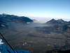
The Naunspitze is a summit in the Kaisergebirge, which is placed in the northern part of tirol, close to the boarders to germany. The Kaisergebirge is diveded in two parts. Zahmer Kaiser and Wilder Kaiser are separated by a small valley, the Kaisertal.The Naunspitze is one of the most frequented summits of the Zahmer Kaiser. The rather easy way to the peak and the very impressive view from the summit is one of the main reasons for the popularity. The view from the summit reaches very far northwards to germany and all along the Inntal (main valley in tirol) up to Innsbruck. At clear weather you have great view to the summits of the tuxer and stubai alps in the northwest.

Getting There
Comming from Innsbruck, drive along the highway A12 to Kufstein (about 80km).Use the Exit "Kufstein Nord". At the traffic circle go left. Then follow the street for about 500m and then go right. 300m ahead you will find place for parking (small parking tax, 2€).
Comming from rosenheim use the highway to austria. If you have passed the boarderline to austria, take the first exit "Kufstein Nord". The follow the describtion above.
The way to the Summit
At the parking place, follow the way to the Kaisertal (valley between Zahmer Kaiser ans Wilder Kaiser). Walk up the stairs, then follow the signs leading the way to Rietzau Alm (about 90 min) and Vorderkaiserfelden (120 min). At Vorderkaiserfelden, walk left the hut. The street changes to a small path which leads you up the mountain. After approx. 30 min the path parts. Following the left arm, you will reach the Naunspitze very fast.Following the right arm, you will reach Petersköpfl after further 30 min.
Digital map for Hiking and Mountaineering
 |
 |
Other peaks around
Petersköpfl - 30min - 1745mEinserkogel - 60min - 1924m
Pyramidenspitze - 120min - 1997m
Vordere Kesselschneid - 150min - 2001m
Overview:
Digital map for Hiking and Mountaineering
Take care:
The trips look rather easy. There are no technical difficulties, but in summer it can get very hot and there is no opportunity to find any water!
Camping
Usually camping is not necessary. There are a few huts around offering accomodation and best food.huts and links:
Vorderkaiserfelden Hütte
phone: +43/(0)5372/63482
Rietzau Alm
phone: +43/(0)5372/63624
Guesthouse in Ebbs
Impressions
 |
 |
Maps and Links
KaisergebirgeKompass Map WK9
1:50.000
Kompass Verlag
ISBN: 3-85491-011-8
Digital map for Hiking and Mountaineering
Digital air photograph