
-
 24143 Hits
-
 81.84% Score
-
 14 Votes
|
|
Route |
|---|---|
|
|
34.28840°N / 117.7133°W |
|
|
Hiking |
|
|
Spring, Summer, Fall, Winter |
|
|
Most of a day |
|
|
Class 1 |
|
|
Overview: Some Say the Toughest Hike in the San Gabriels
The route from Heaton Flat along the Heaton Flat Trail, and then along its south ridge, is the most frequently used route to Iron Mountain #1, aka "Big Iron." But the route is demanding. A round-trip by this route is 14 miles with 7,200 feet of elevation gain. The last mile to the summit itself packs 2,000 feet of gain. And the last 600 feet of gain is on the return!Getting There
From Interstate 210, take the Azusa Avenue (SR 39) exit and go north winding up San Gabriel Canyon about 12 miles to where the East Fork Bridge intersects SR 39. Turn right, go across the bridge, and continue straight. In about 5 miles, you will come to a point where the road starts to curve very sharply right and uphill. Right at this curve, you will see a road straight ahead of you. Continue straight onto this road and in less than a mile you will come to the large paved parking lot at the end of the road overlooking the East Fork of the San Gabriel River. Park here. The trailhead is at 2,030 feet elevation and you need to get to 8,007 feet. Sign at entrance to parking area for Heaton Flat Trail
Red Tape
A permit is required to hike the Heaton Flat Trail. Permits are available at the San Gabriel River Ranger District, 110 N. Wabash, Glendora, telephone 626.335-1251, or from the United States Forest Service Entrance Station on SR 39.You will also need an Adventure Pass to park at this trailhead. They can be purchased at most sporting goods stores. Cost is $5 per day or $30 for a yearly pass.
Route Description
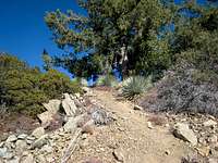
From the trailhead parking area, go past the large gate and hike north and east on the road that follows above the river bank for about ½ mile. There, by a smelly outhouse, the Heaton Flat Trail (designated 8W16) begins on your right.The trail heads generally northeast and is moderate in incline compared with what is to come. Continue on the trail up to the top of the ridge. You will come to small clearing with a wooden sign pointing to Bonita Peak. From here, the trail gets a little tougher as it continues over several small bumps until you reach the top of the trail at Allison Saddle. The elevation at this saddle is 4,582 feet, so you have gained a little over 2,500 feet since the start in about 3.5 miles. If you're doing this route on a hot day and are carrying extra water, this is a good place to stash it for the return.
From here, you head north up Iron's ridge along a use trail.
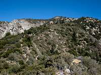 Part of South Ridge Route to Big Iron
 A tree trunk straddles a bush along the Iron ridge
 View of Mt. Baldy from Iron's south ridge
 Looking east to Big Horn Ridge from Iron's south ridge
You will hike over 3 major bumps between Allison Saddle and the summit, at elevations 5,385, 6,138, and 7,264 feet.
 One of the bumps on the south ridge
The last mile involves 2,000 feet of gain.
 Looking at a rare shady rest stop along the south ridge within a mile of the summit
At the summit, check out the San Antonio Ridge that will take you to West Baldy and Baldy if you're in the market for a really advanced hike.
You will probably find the descent back to Allison Saddle a little challenging due to the steepness of the ridge and looseness of the dirt underfoot, providing a precarious escalator-like ride between the ever-present Yucca and Buckthorn. Trekking poles may be useful here.
You'll likely breathe a sigh of relief when you get back to Allison Saddle, knowing that a regular trail awaits your tired body back to the trailhead.
Essential Gear
None. However, the mountain does see snow during the winters and on those occasions you should wear hiking boots.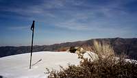 Summit of Iron on Feb. 25, 2006
 Wintery scene along the route in Feb. 2006
 On the ridge near the summit in April 2006
Otherwise, if the trail and ridge are dry, the route can be done in trail runners.
Trekking poles can very useful on this route, particularly for the extremely steep first mile descending from the summit.
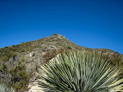
It is strongly recommended that you wear long pants and long sleeves as protection against the abundant needle-sharp Yucca plants (and Buckthorn) encroaching on the trail. Like the one you see below.
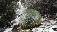 Yucca along south ridge route to Iron
Other Information
Most of the route is extremely exposed to the sun. Avoid this route during the summer unless you want a real suffer-fest. If you do it in the summer, take 6 liters of water minimum; you can stash some at Allison Saddle and pick it up on the way back.USGS Topos Mount San Antonio 7.5 Mt. Baldy 7.5 Glendora 7.5