
|
|
Route |
|---|---|
|
|
34.27200°N / 117.727°W |
|
|
Hiking |
|
|
Spring, Fall, Winter |
|
|
A long day |
|
|
Class 3 |
|
|
Overview
Iron #1 is difficult by any route but there are always newer, more challenging approaches to climb one of the toughest peaks in the San Gabriel Mountains. It is unknown as who made the first ascent using the SW Ridge route but the approach has been chronicled in one of the most recent Sierra Club Hundred Peaks Section newsletters. This is not a trivial route and should not be treated as such even though the author of the trip report in the news letter claims that it’s easier and faster than the traditional route.Getting There
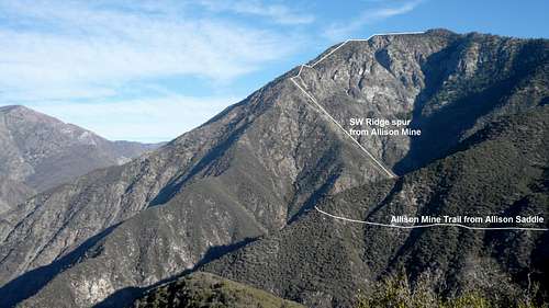 Approximate location of SW ridge route from Allison Mine
The route begins roughly at the old Allison mine located at over 4000’ up the Allison Gulch. There are two possible ways to get to the mine.
1. Take the Heaton Flats trail to Allison Saddle (about 4 miles). At the saddle, a poorly marked and somewhat overgrown trail heads left (west) to the mine for about 2 miles. Once at the mine, cross the creek and proceed a couple hundred feet until you’re at a steep slope of talus.
2. Follow the San Gabriel River East Fork trail from Heaton Flats about 3 miles until you hit Allison Gulch (just after passing Swan Rock). You will probably have to cross the river several times before you gain entry to the canyon. Hike up the canyon a short ways until you reach the beginning of a use trail (34.267, 117.736) on your left. Follow this up some steep switchbacks before it heads up the canyon. You’ll hit the slope of talus just before you get to the mine.
Route Description
 Start of the route (photo courtesy of Travis
The route is fairly straight forward with your goal being the Southwest Ridge. Climb the talus slope, moving off of it to more stable ground as quickly as possible. Weave in and out of the brush, keeping it to a minimum, and gain the rocky, subsidiary ridge that will take you all of the way to the main ridge. This ridge involves sustained class 3 climbing over mostly poor quality rock (check every hand hold), climbing ~1700’ in less than half a mile. Once on the main ridge head up to the first intermediate bump and down into the saddle. Stay as far right as possible due to the dense brush (the right side appeared to be easier than the left side). Once you have forced your way through the thickets of Buckthorn, continue climbing the now steepening ridge until you get to the summit plateau area just below the final climb. A good use trail exists for the end of the hike. After forcing your way through the brush on the plateau, follow the normal trail the short distance to the top. Use the standard South Ridge route for your descent.
Essential Gear
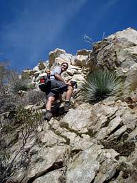 Some class 3 (photo courtesy of Travis
It is recommended that you have covering for legs, arms and hands due to the bushwhacking you will do on the ridge portion of this route. Hiking boots, as opposed to trail runners, are also recommended. Trekking poles may be useful for the first few miles of steep descent from Iron’s summit along its south ridge.
A change of socks may be convenient due to the numerous stream crossings on the approach to the base of the mountain. You can also use appropriate shoes (i.e. Tevas or other sandals) and change once you get to the outlet of Allison Gulch.
After leaving Allison Mine, there are no water sources until returning to the trailhead. Carry sufficient water depending on your normal intake; summer months will require more. There are emergency rations of water located at the helicopter pad on the south ridge descent.
External Links
Angeles Forest website.Travis Lind’s GPS Mountaineering Page
San Gabriel Mountains Discussion Board
geot1 - Jun 3, 2012 11:54 pm - Hasn't voted
Allison Trail collapsedI maintained the Allison Mine trail from the Heaton Flat trail to the final section for a few years. Last year I discovered part of the north facing section has collapsed. It is not very safe. Take the river to Allison Creek, see the route from there to the ridge. A short way up the route to the SW ridge is a spectacular rescue trail leading to the mine, worth a visit.