
-
 13745 Hits
-
 80.49% Score
-
 12 Votes
|
|
Route |
|---|---|
|
|
34.28840°N / 117.7133°W |
|
|
Scrambling |
|
|
Spring, Summer, Fall, Winter |
|
|
A long day |
|
|
Class 1, some Class 3 |
|
|
Overview
This route is a challenging alternative to the standard approach to Iron Mountain #1 by the Heaton Flat Trail and south ridge route. It is also arguably tougher than the San Antonio Ridge route to Iron from Mt. Baldy.Getting There
From either Interstate 210 or Interstate 10, take the Azusa Avenue (SR 39) exit and go north winding up San Gabriel Canyon about 12 miles to where the East Fork Bridge intersects SR 39. Turn right and go across the bridge. In about 6 miles, you will come to a point where the road starts to curve very sharply right and uphill. Right at this curve, you will see a road straight ahead of you. Take a left onto the right hand lane of the road you’ve just seen and in less than a mile you will come to the large paved parking lot at the end of the road overlooking the East Fork of the San Gabriel River. Park here.From the trailhead parking area, go past the large gate and start hiking north on the road that parallels the East Fork bank.
Route Description
The distance to the base of the climb is somewhere between 8 and 9 miles along river habitat. From the trailhead, proceed north along the road above the bank of the East Fork of the San Gabriel River. You will soon drop down into the river. From here, it is a matter of following the existing trail when you can and making river crossings as necessary. The river portion of this route will provide you in the range of 30 or so crossings.In 4.5 miles you will cross over the “Bridge to Nowhere” and then enter a section of the East Fork known as “The Narrows.”

East Fork of San Gabriel River, 5.19.07

Swan Rock on west side of East Fork bank
At the junction of the East Fork with Fish Fork, head east (right) along Fish Fork until you reach the south branch of Fish Fork. Take the south branch (it travels southeast) for about ½ mile. At this point, begin looking for the prominent gully ascending south and a little west, and that meets the long ridge descending just to the east of what is shown on the San Antonio 7.5 topo as Falls Gulch. If you get to a place where the south branch of Fish Fork goes underground, you have gone too far upstream.
At the base of the gully, you are at about 4,040 feet elevation. Now the steep climbing begins. Ascend the gully approximately 2,000 feet to the ridge east of Falls Gulch. The ridge is gained at about 5,900 - 6,000 feet elevation.

Looking down gully to Fish Fork River from near north ridge, 5.20.07
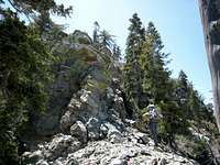
A typical segment of the north ridge, 5.20.07
As you ascend the ridge, you will encounter a few sections of 3d class rock, but much of it is loose and brittle, so proceed carefully. At about 7,750 feet, you will come to an overlook on the ridge. From there, you will be able to see your objective approximately ¼ of a mile away. The total distance up gully and ridge to the summit is about 2.5 miles with 4,000 feet of gain.

Looking down north ridge from near Iron's summit 5.20.07

Summit of Iron Mtn.#1 (8,007') from north ridge
The recommended descent route is down the south ridge of Iron to the Heaton Flat Trail and back to the trailhead. The south ridge is much less steep than the north ridge you have come up. Another advantage of a south ridge descent is that, for the entire route, you will have made a nice loop of about 18-19 miles with about 7,000 feet of gain, as opposed to retracing your steps.
Essential Gear
It is recommended that you have covering for legs, arms and hands due to the bushwhacking you will do on the gully and ridge portion of this route. Hiking boots, as opposed to trail runners, are also recommended. Trekking poles may be useful for the first few miles of steep descent from Iron’s summit along its south ridge.A change of socks may be convenient due to the numerous stream crossings on the approach to the base of the mountain.
Should the route be done in winter, you must assess what other gear is appropriate.
Red Tape
A permit is required to enter the Sheep Mountain Wilderness Area from the Heaton Flat Trail. Permits are free and are available at the following locations:San Gabriel River Ranger District, 110 N. Wabash, Glendora, telephone 626.335-1251 (Monday–Friday, 8 a.m. to 4:30 p.m.);
San Gabriel Entrance Station on SR 39, telephone 626.969-1012 (Monday-Thursday, 10 a.m. to 3 p.m. and Friday-Sunday, 8 a.m. to 4:30 p.m.); and
Angeles National Forest Office, 701 N. Santa Anita Ave., Arcadia, CA 91006, telephone 626. 575-5200 (Monday-Friday, 8 a.m. to 4:30 p.m.)
Other Information
After leaving Fish Fork, there are no water sources until returning to the trailhead. Recognizing that individual needs vary, it is nevertheless recommended that you carry a minimum of 5 liters of water assuming only moderate air temperatures.This is a tough route to complete in one day. Depending on how much you want to push yourself, you might consider an overnight at the base of the climb and do the challenging climb the next day.
USGS Topos Mount San Antonio 7.5 Crystal Lake 7.5 Mt. Baldy 7.5