|
|
Route |
|---|---|
|
|
Overview
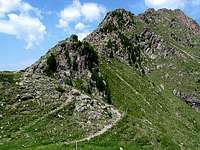
The impressive Lagorai range the Eastern part of Trentino is a real and unspoiled paradise for all trekking and it is an amazing and interesting group that brings hiker in a dream land. |
Getting there
VAL DI FIEMMEby car using the autoroute A22 (Brennero-Modena)
by bus using the public transportation of Trentino Trasporti
Tickets available directly on the bus
by train
along tha railway Bolzano-Ora F.S.-Cavalese-Predazzo
Info: 1678/46047
VALSUGANA
Venezia (Marco Polo Airport) - Milano (Linate Airport) - Bolzano (Bolzano Sud Airport)
 |
Maps:
Route description
| Path 343 - Cima Sette Selle: Valsugana - Val dei Mocheni - Palù del Fersina - path 370 - Rifugio Sette Selle - path 343 | |||
| difference in elevation 875mt..- time required - difficulty | |||
|


| Path 325 - Monte Gronlait and Fravort: Valsugana - Levico - Panarotta- path 325 (E5) - la Bassa - M. Fravort - Forcella Fravort - M.Gronlait | |||
| difference in elevation 887mt. .- time required - difficulty | |||
|


| Path 462 - Monte Rujoch: Valsugana - Val dei Mocheni - Regnana - path 443 - Val Spruggio - path 340 - Rifugio Tonini - path 462 - | |||
| difference in elevation .- time required - difficulty | |||
|


 |
| Path 460 - Monte Croce : Valsugana - Calamento Valley - Malga valtrighetta - path 370 - Malga Cagnon di sopra - path 407 - Scalet Pass - path 460 | |||
| difference in elevation 981mt..- time required - difficulty | |||
|


| Path 373 - Cima delle Buse Todesche: Valsugana - Campelle Valley - Tedon - path 332 - Val Caldenave - path 360 - Laghetti Val d'Inferno - path 373 - Cima delle Buse Todesche | |||
| difference in elevation .- time required - difficulty | |||
|


| Path 317B - Cimon di Valmoena: Val di Fiemme - Cavalese - Valmoena - Ponte Brustolaie - Stalla Vecchia - path 317B | |||
| difference in elevation .- time required - difficulty | |||
|