
|
|
Route |
|---|---|
|
|
46.17246°N / 11.44123°E |
|
|
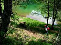
wandering around the lakes of the Lagorai chain II
We are in the heart of the long Lagorai chain that extends from Trento to Passo Rolle located in the Eastern part of Trentino.A long sequence of peaks of porphyry rock at first sight insurmountable.The glaciers have carved cirques and moraines that now form hundreds of lakes and bogs.
lagorai is a special and fascinating world : it's a contact with wild and solitary nature and the hundreds of lakes are many jewels in these austere and majestic environments.
Lago delle Buse 2060 m.
| Drainage Basin: Avisio, Rio Cadino. Mountain group: Plesso di Cima d'Asta,Sottogruppo Catena del Lagorai Surface area:23.000 mq Getting there:Valsugana - Borgo Valsugana - Val Calamento - Passo Manghen 2047m Lago delle Buse 2067m is a small lake of glacial origin in the Val Cadino, one side of the Val di Fiemme.Starting from Passo Manghen 2047m and take the trail 322A till the lake. 0. General: 2047m to 2060m, marked. 1. Effort:1h 2. Power: 1 3. Psiche: 1 4. Orientation: 1 Maps:kompass 618 Val di Fiemme-Catena dei Lagorai kompass 621 Valsugana- Cima D'Asta -Val dei Mocheni kompass 626 Catena del Lagorai - Cima D'Asta |  Lago delle Buse 2060 m. Lago delle Buse 2060 m. |
 |
 Forcella Ziolera Forcella Ziolera |  The Path 322A The Path 322A |  Passo Manghen Passo Manghen |
Lago delle Prese 1620m.
| Drainage Basin: Brenta, Torrente Larganzola Mountain group: Plesso di Cima d'Asta,Sottogruppo Catena del Lagorai Surface area:2.500 mq Getting there:Valsugana - Levico Terme - Roncegno Terme - Rifugio Serot- Path 371. From Levico Terme follow the road of valsugana towards Padova untill Roncegno Terme 535m. From this area you can reach Le Pozze 1402m and then Prese.The road continue to the refuge Serot 1566m.; from here the path 371 leads to the beautiful Lago delle Prese 1620m and the Val Portella untill the Passo Portella 2152, the door of the western Lagorai. 0. General: 1566m to 2152m, marked. 1. Effort:1.30h 2. Power: 1 3. Psiche: 1 4. Orientation: 1 Maps:kompass 618 Val di Fiemme-Catena dei Lagorai kompass 621 Valsugana- Cima D'Asta -Val dei Mocheni kompass 626 Catena del Lagorai - Cima D'Asta |  Lago delle Prese Lago delle Prese |
 |
 Lago delle Prese 1620m Lago delle Prese 1620m |  Val Portella Val Portella |  |
Lago di Erdemolo 2024m.
| Drainage Basin: Fersina Mountain group: Plesso di Cima d'Asta,Sottogruppo Catena del Lagorai Surface area:15.500 mq Getting there:Valsugana - Pergine - Valle dei Mocheni - Palù del Fersina - Località Frotten - Path 325. Leave the car at the parking (1500m) in Palu del Fersina( Frotten). From here start the path 325 that leads to the Lake and the Refuge of Erdemolo. The path first climbs into the forest near a few old farms and then it cross the torrent Fersina. It passes near Maso Erdemolo 1707m. The lake is at 2024 m in a valley surrounded by mountains. 0. General: 1500m to 2024m, marked. Prevailing exposition N 1. Effort:1.30h 2. Power: 2 3. Psiche: 1 4. Orientation: 1 Maps:kompass 618 Val di Fiemme-Catena dei Lagorai kompass 621 Valsugana- Cima D'Asta -Val dei Mocheni kompass 626 Catena del Lagorai - Cima D'Asta |  Lago di Erdemolo 2024m Lago di Erdemolo 2024m |
 |
 Lago di Erdemolo 2024m Lago di Erdemolo 2024m | 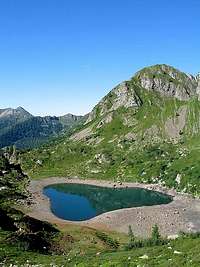 |  Lago di Erdemolo from Forcella del Lago 2295m Lago di Erdemolo from Forcella del Lago 2295m |
Laghetti Val d'Inferno 2094m.
| Drainage Basin: Brenta, Rio Maso di Spinelle,Rio Conseria. Mountain group: Plesso di Cima d'Asta Massiccio Centrale Surface area:3.700mq - 7,300mq - 3.100mq Getting there:Valsugana - Borgo Valsugana - Strigno - Val Campelle - Ponte Tedon - Path 332 - Caldenave - Val dell'Inferno - Path 360 - Lago Cengello - Laghi Lasteati Approach by car: From Strigno in Valsugana Valley, follow the signs for the restaurant "the Crucolo", for few kilometers until you reach the parking near the wooden bridge ( Tedon 1350m, 10 km from Strigno) Start from Tedon bridge 1350m with trail No. 332 and go up along the torrent Caldenave. Easily passed a final steep section, the trail reaches a valley in a very beautiful and open glade. We are in the Val Caldenave 1780m. Surely one of the most beautiful places that can meet in the Lagorai From the Refuge Caldenave (10 minutes) it start another valley that extends until the feet of mountains Caldenave and Orsera. Go along the valley till the path No. 360 that leads in half an hour to the Laghi della Val d'Inferno (1960 m). Continue uphill along the path that leads to a saddle where we proceed to the south by path 360 and after passing through the base of Mt Conseria you reach the third of the Laghi d'Inferno 2094m. You reach a junction signposted from tables (m 2190) which is the highest point of our journey. Here we abandon the path No. 360, which leads to the fork of Buse Todesche and so take a left down along a track not found on official maps, but still visible on site with the code L35, leading in about half an hour to Lake Cengello (1990m) Later we meet the lakes Lasteati . Then we continue along the feet to Cima Socede , with the path 326 that goes down of Malga Conseria 1821m, Ponte Conseria, Malga Caserine, and then Ponte Tedon, the starting point. 1. Effort: 900m, 8h 2. Power: 2 3. Psyche: 2 4. Orientation: 1 – no difficulties Maps:kompass 621 Valsugana - Tesino Maps:kompass 618 Val di Fiemme-Catena dei Lagorai kompass 626 Catena del Lagorai - Cima D'Asta | 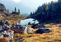 Laghetto Val d'Inferno - 3° 2094m Laghetto Val d'Inferno - 3° 2094m |
 |
 Laghetto Val d'Inferno - 1° 1955m Laghetto Val d'Inferno - 1° 1955m |  Laghetto della val d'Inferno - 1° 1955m Laghetto della val d'Inferno - 1° 1955m |  |
Lago di Lasteati 2063m.
| Drainage Basin: Brenta, Rio Maso di Spinelle,Rio Conseria. Mountain group: Plesso di Cima d'Asta Massiccio Centrale Surface area:8.000 mq Getting there:Valsugana - Borgo Valsugana - Strigno - Val Campelle - Ponte Tedon - Path 332 - Caldenave - Val dell'Inferno - Path 360 - Lago Cengello - Laghi Lasteati. see route description for Laghetti Val d'Inferno Maps:kompass 618 Val di Fiemme-Catena dei Lagorai kompass 621 Valsugana- Tesino kompass 626 Catena del Lagorai - Cima D'Asta |  Lasteati 2063m Lasteati 2063m |
 |
Lago del Cengello 1990m.
| Drainage Basin: Brenta, Rio Maso di Spinelle,Rio Conseria. Mountain group: Plesso di Cima d'Asta Massiccio Centrale Surface area:3.200 mq Getting there:Valsugana - Borgo Valsugana - Strigno - Val Campelle - Ponte Tedon - Path 332 - Caldenave - Val dell'Inferno - Path 360 - Lago Cengello - Laghi Lasteati See route description for Laghetti Val d'Inferno Maps:kompass 618 Val di Fiemme-Catena dei Lagorai kompass 621 Valsugana- Tesino kompass 626 Catena del Lagorai - Cima D'Asta |  Lago del Cengello 1990m Lago del Cengello 1990m |
 |
 |  | |
Laghi di Ravetta 2125m.
| Drainage Basin: Brenta, Rio Chieppena ,Rio Gallina. Mountain group: Plesso di Cima d'Asta Massiccio Centrale Surface area:12.000mq - 10.00mq - 15.00mq Getting there: Trento - SS47 Valsugana - Villagnedo - Pieve Tesino - Rifugio Spiado 1270m Grasslands, lakes and towering rocky ridges characterize this trip that highlights the most fascinating aspects of Lagorai, transforming a simple hike in the mountains in a real adventure in an untouched nature. From Trento after the motorway exit (A22), take the SS47 Valsugana towards Bassano, following it up to Villagnedo (40km), turn left and take the provincial road No. 78 going up to the plateau of Tesino. Bassano Del Grappa - Take the SS47 Valsugana towards Trento until Villagnedo (50km), turn right and take the provincial road No. 78 going up to the plateau of Tesino. by train: Valsugana, both from Trento to Bassano, Borgo Valsugana stations, and Strigno Ospedaletto. Regular connections by bus and Borgo Trento Valsugana. In air, the closest airports are in Bolzano, Venice and Verona. From Refuge Genzianella (1270m) along a forestal road and the path 365, going up across a larches wood and wide pastures, you get Malga Fierollo di Sotto (1563m) then, along the path 332, up to Malga Rava di Sotto. Follow the whole valley (Val di Rava) along glades and peat bogs, under the first big rocky towers. Beyond Malga Ravetta di Sotto (about 500m), once at the fork follow the mark 366 toward NE: herefrom you remount up to the highland of Malga Rava di Sopra (2080m) and the close First Lake (1999m), Then, along the path 328, up to the Lago Grande (2125m) Maps:kompass 618 Val di Fiemme-Catena dei Lagorai kompass 621 Valsugana- Tesino kompass 626 Catena del Lagorai - Cima D'Asta |  Lago Grande 2125m Lago Grande 2125m |
 |
 Lago Primo 1999m Lago Primo 1999m |  Lago di Mezzo 2044m Lago di Mezzo 2044m | 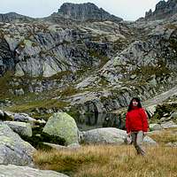 Lago Grande 2125m Lago Grande 2125m |
