
|
|
Route |
|---|---|
|
|
46.24742°N / 11.51573°E |
|
|
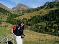
wandering around the lakes of the Lagorai chain I
The Chain of Lagorai is a mountain range located in the Eastern part of Trentino and one of the largest natural areas in the entire province, including some of the wildest corners of south-eastern Alps. Lagorai is a name that has roots in the word lake, in fact there are numerous lakes larger or smaller at several quote.Here are listed some
Lago di Cece 1879 m.
| Drainage Basin: Avisio, Torrente Travignolo,Rio delle Laste Mountain group:Sottogruppo Catena del Lagorai Surface area:20.000 mq Getting there: Val di Fiemme - Predazzo - Valmaggiore From Predazzo (Val di Fiemme) take the southeast road for Valmaggiore. It's a long forest road that leads through beautiful woods. At the Valmaggiore bridge (1570m) leave the forest road and take the path 336, the trail climbs gradually through the woods to the valley of Lake Cece (1879m). There is a cabin with bivacco. Near the north shore of the lake Cece there is a bridge that crosses the torrent : take the path 336 that dates a steep ridge in the woods. At 1986m he leaves the forest The path now continues along the torrent that you should wade easily. Take on the right side and follow the trail to the beautiful valley of Lake Caserine 2087m and its crystal clear waters. 0. General: 1570m to 2087m, marked path 336 1. Effort: 600m, half a day 2. Power: 1 3. Psiche: 1 4. Orientation: 1 Maps:kompass 618 Val di Fiemme-Catena dei Lagorai kompass 621 Valsugana- Cima D'Asta -Val dei Mocheni kompass 626 Catena del Lagorai - Cima D'Asta |  Lago di Cece 1879 m. Lago di Cece 1879 m. |
Lago Caserine 2087m.
| Drainage Basin: Avisio, Torrente Travignolo,Rio del Valonat Mountain group:Sottogruppo Catena del Lagorai Surface area:1.500 mq Getting there: Val di Fiemme - Predazzo - Valmaggiore - path 336- Lake Cece - path 336 - Lago Caserine. 0. General:The same route as above, Lago di Cece. |  Lago Caserine 2087m. Lago Caserine 2087m. |
 |
 Lago di Cece: cabin with bivacco Lago di Cece: cabin with bivacco |  |  Lago Caserina 2087m and Cima di Cece 2754m Lago Caserina 2087m and Cima di Cece 2754m |
Lago Moregna 2058m.
| Drainage Basin: Avisio, Torrente Travignolo,Rio di Valmaggiore Mountain group:Sottogruppo Catena del Lagorai Surface area:17.800 mq Getting there: Val di Fiemme - Val di Travignolo - Valmaggiore - Valmaggiore alm 1620m. - path 339 - Moregna alm - Lago Moregna The area of Lake Moregna in the Eastern Lagorai is very enchanting,near Lake Moregna there are two lakes: Lake Trote and Lake Brutto. From Predazzo(Val di Fiemme), just before the bridge, take the road to Val Maggiore. From Malga di Valmaggiore ( starting point) 1608m take the trail 339 . The path which climbs quite steep on the ridge of a valley rather inaccessible and narrow, the Busa of Slavaci; then you come to a small clearing where the vegetation and the valley opens: and finally emerges in one amphitheater at the foot of Cima Moregna. On the edge of the basin is pasture, with a small but confortable bivacco, just below the lake Moregna with its beautiful flat shore that invites you to rest, not far from Lake Moregna, is located Lago delle Trote, opposite the Monte Cadinon.Farther south, between Cima Moregna and Colrotondo at an altitude of 2207, lies Lake Brutto.From here we proceed to the Forcella Moregna 2397m 0. General: 1620m to 2397m 1. Effort: 800m, 1 day 2. Power: 1 3. Psyche: 2 4. Orientation: 2 Maps:kompass 618 Val di Fiemme-Catena dei Lagorai kompass 621 Valsugana- Cima D'Asta -Val dei Mocheni kompass 626 Catena del Lagorai - Cima D'Asta |  Lago Moregna 2058m. Lago Moregna 2058m. |
Lago Brutto 2207m.
| Drainage Basin: Avisio, Torrente Travignolo,Rio delle Pozze Mountain group:Sottogruppo Catena del Lagorai Surface area:17.200 mq Getting there: Val di Fiemme - Val di Travignolo - Valmaggiore - Valmaggiore alm 1620m. - path 339 - Moregna alm - Lake Brutto. 0.General:The same route as above, Lago di Moregna. |  Lago Brutto 2207m Lago Brutto 2207m |
 |
Lago Lagorai 1871m.
| Drainage Basin: Avisio, Rio Lagorai Mountain group:Sottogruppo Catena del Lagorai Surface area:93.000 mq Getting there: Val di Fiemme - Cavalese - Masi di Cavalese 888m - Val Lagorai - path 316. Start from Val di Fiemme, Masi di Cavalese, Val Lagorai. Take the road 316 that goes across the Val Lagorai formed by the torrent. Keep to the left of the torrent, it take an hour and a half to reach the plain where lies the lake and alm Lagorai 1871m. Following the road along the lake on the left: Forcella Cadinello while straight go up to the lakes Bombasel and the Cermis 0. General: 888m to 1871m, marked 1. Effort: 1000m, 1 day 2. Power: 1 3. Psyche: 2 4. Orientation: 1 Maps:kompass 618 Val di Fiemme-Catena dei Lagorai kompass 621 Valsugana- Cima D'Asta -Val dei Mocheni kompass 626 Catena del Lagorai - Cima D'Asta |  Lago Lagorai 1871m. Lago Lagorai 1871m. |
 |
 Lago Lagorai 1871m Lago Lagorai 1871m |  Lagorai Valley Lagorai Valley |  Lago Lagorai Lago Lagorai |
Lago delle Stellune 2099m
| Drainage Basin: Avisio, Rio Cadino,Rio delle Stue Mountain group:Sottogruppo Catena del Lagorai Surface area:28.000 mq Getting there: Valsugana - Val Calamento - Passo Manghen 2047m. From Passo Manghen along the trail 322, climbs easily into the great amphitheater that arrives to Forcella del Frate 2238 m .From the Forcella del Frate to the summit (north-east) of Monte Ziolera 2478m: an exceptional point of view to 360 degrees. From the top of Ziolera, descend carefully (traces) along the ridge north-east to the Forcella Ziolera m 2232.then take the trail 322B till Forcella Pala del Becco then crossing on boulders, (pay attention) till Lake Montalon. Going up along the trail 322A ,reach the Forcella Montalon and then (trail 322) our destination, the beautiful Lake of Stellune. Then in a short time you can reach the Forcella di Valsorda ( path 318) at 2256m and Laghi delle Buse Basse o laghi di Rocco. Return: the same path until Forcella Montalon, and then along the path 322A to Lake of Buse and Passo Manghen. 0. start altitude 2047m summit altitude 2091m Prevailing exposition NE 1. Effort: 650m, 4h 2. Power: 2 3. Psiche: 3 4. Orientation: 3 Maps:kompass 618 Val di Fiemme-Catena dei Lagorai kompass 621 Valsugana- Cima D'Asta -Val dei Mocheni kompass 626 Catena del Lagorai - Cima D'Asta |  Lago delle Stellune 2099m. Lago delle Stellune 2099m. |
 |
 Lago delle Stellune 2099m Lago delle Stellune 2099m |  Lago delle Stellune Lago delle Stellune |  Lago delle Stellune Lago delle Stellune |
Lago di Montalon 2089m
| Drainage Basin: Brenta, Rio Maso,Rio Maso di spinelle, Rio di montalon Mountain group:Sottogruppo Catena del Lagorai,Sottogruppo del fravort Surface area:4.400 mq Getting there: Valsugana - Val Calamento -Passo Manghen 2047m. - path 322 0.General:The same route as above, Lago delle Stellune. Maps:kompass 618 Val di Fiemme-Catena dei Lagorai kompass 621 Valsugana- Cima D'Asta -Val dei Mocheni kompass 626 Catena del Lagorai - Cima D'Asta |  Lago di Montalon 2089m. Lago di Montalon 2089m. |
 |
 Montalon Valley Montalon Valley |  |  |
Lago delle Buse Basse o Rocco inferiore e superiore 2137 m.
| Drainage Basin: Brenta, Rio Maso,Rio Maso di Spinelle, Rio Val Sorda Mountain group: Plesso di Cima d'Asta,Sottogruppo Catena del Lagorai Surface area:13.000 mq and 8.500 mq. Getting there:Valsugana - Val Campelle - Ponte di Conseria - Path 317 - Malga Valsorda. 0.General:The same route as above, Lago delle Stellune. Maps:kompass 618 Val di Fiemme-Catena dei Lagorai kompass 621 Valsugana- Cima D'Asta -Val dei Mocheni kompass 626 Catena del Lagorai - Cima D'Asta | 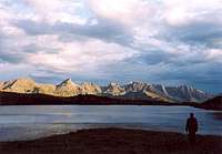 Lago delle Buse Basse Inferiore Lago delle Buse Basse Inferiore |
 |
 Lago delle Buse Basse 2137m Lago delle Buse Basse 2137m |  Forcella Val Sorda Forcella Val Sorda |  |
