Introduction and Trip Overview
Teton Range (July 4-10)
Northeast Yellowstone / Absaroka and Beartooth Mountains (July 10-17)
For 2 weeks every summer, we leave the heat, humidity, gnats, ticks, and thick vegetation of the Southern Appalachians behind for a refreshing 2 weeks in the Rocky Mountains. While we usually visit Colorado, we were ready for a change and decided to head further north – opting for the northwest corner of Wyoming. We were leery of being near Grand Teton and Yellowstone National Parks during the peak of summer activity, but figured with careful planning, we could avoid most of the major crowds. That led us to one week in Victor, ID with the intent of exploring the less crowded western slopes of the Teton Range followed by one week in Silver Gate, MT situated between the less frequently used Northeast entrance to Yellowstone and the Absaroka / Beartooth Mountains to the north and east.
For those looking for a trip report loaded with epic technical climbs, you may be disappointed. For one, we’re not technical climbers. And secondly, a bad tear in my wife’s shoulder left her reluctant to hike anything too steep where a simple slip and fall could put her completely out of commission. We contemplated some easier non-technical summits (e.g., Table Mountain), but instead landed on doing a large number of dayhikes without a ton of steep or loose terrain. For some variety, we also threw in some cycling (during week #1 only) – I kept any cycling recaps brief so as not to upset the SP purists.
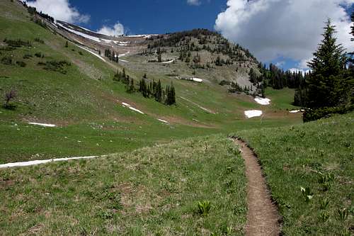
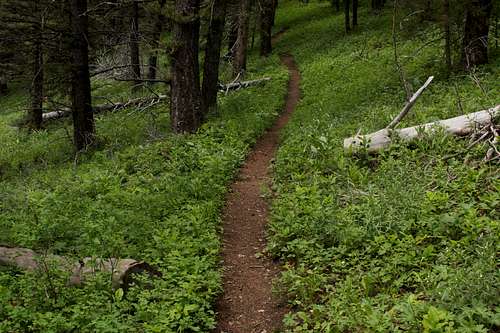
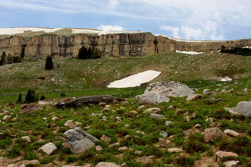
Day One: Coal Creek Meadows/Mesquite Creek Divide/Moose Meadows (Jedediah Smith Wilderness, Caribou-Targhee National Forest)
Nothing beats the satisfaction of being the first car at the trailhead in the morning – especially one so close to jam-packed Jackson, WY on July 4. Such was our luck on day one. This trail starts near Teton Pass and climbs an easy/moderate grade as it follows Coal Creek through the trees before breaking out into Coal Creek Meadows. Taylor Mountain’s impressive east face is visible through much of this segment. At the north end of Coal Creek Meadows, the trail splits – one trail heads west to a saddle leading to either Taylor Basin or the Taylor summit…the other continues north with a short climb to Mesquite Creek Divide (sometimes called Coal Creek Divide). The Divide provides great views north into the Teton Range before dropping down toward Moose Meadows. We continued on toward Moose Meadows. Unfortunately, a quickly brewing storm coming over Taylor Mountain necessitated a turnaround about a mile after the divide. The storm eventually fizzled out allowing us to take our time. Closer to the trailhead, we were excited to see a cow moose rummaging through the willows along Coal Creek. Since there are no moose in the heat of the Southern Appalachians back home, we enjoyed the show.
![Coal Creek Meadows]() Coal Creek Meadows
Coal Creek Meadows![Taylor Mountain East Face]() Taylor Mountain
Taylor MountainDay Two: Grand Targhee and Teton Valley
No major hikes – today was our only day dedicated to cycling. We mountain biked at Grand Targhee – hammering out several fun wildflower-filled loops at Rick’s Basin and climbed the service road to the summit of Fred’s Mountain before descending some fun singletrack. Most ski area service roads are not ridiculously steep – Targhee’s dirt road however foregoes switchbacks and essentially runs straight up. While we don’t ride at ski resorts very often, we’ve always held to the old school philosophy of not riding the lifts up – one must earn the descent and ride to the top. An afternoon road ride around Victor and Driggs provided sweeping views of the Teton Range to the east and the Big Hole Mountains to the south and west.
Day Three: Cascade Canyon (Grand Teton National Park)
We knew we wanted to do at least one “classic” dayhike in GTNP. The choices were narrowed down to Paintbrush Canyon, Death Canyon, and Cascade Canyon. While we would have loved to do a longer 15-20 mile dayhike, our time was limited as we had to get back to our dogs at the cabin (since they are shunned from all national parks - probably a good thing unfortunately). We chose Cascade because the easier terrain would allow us to get further up the canyon before we would have to turn around. In order to avoid the excessive crowds that can overwhelm this trail, we made sure we were on the first 7am boat across Jenny Lake. We shared the boat ride with only one other hiking couple and a large group of big wall climbers.
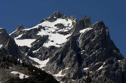
![Heading west through Cascade Canyon]() Cascade Canyon Trail
Cascade Canyon Trail![Mount Owen from Cascade Canyon]() Mount Owen from Cascade Canyon
Mount Owen from Cascade Canyon
The relatively early start paid off as we didn’t see a soul until just after the North/South Fork split when we started running into some backpackers returning from an overnight stay at Lake Solitude. This trail was everything we expected with impressive views on both sides of the canyon. About 3 miles in, we abruptly yielded the trail to a lone cow moose – she was only 10 feet away in thick vegetation and walking directly for us when we first spotted her. The close, unexpected encounter certainly got the heart rate up momentarily. After a long break in a meadow before Lake Solitude, we turned around for the return trip. Other than a large bull moose sighting, our attention turned to the masses of people (I shun to call them hikers because some of them were several miles into the canyon without even the minimal water or rain gear). We just bit our lip and tried to rush through the last two miles taking solace in the fact that we had the canyon completely to ourselves several hours earlier. It would have been nice to have done the complete Cascade-Paintbrush loop, but that will have to wait for another time…
![Moose in Cascade Canyon]() Moose in Cascade Canyon
Moose in Cascade Canyon![Curious marmot]() Marmot in Cascade Canyon
Marmot in Cascade CanyonDay Four: Moose Creek (Jedediah Smith Wilderness)
The Moose Creek trailhead is located several miles from the base of Teton Pass on the Idaho side. The trail offers a very gradual climb up the Moose Creek drainage before eventually connecting with Moose Meadows. The Moose Creek trail is heavily forested making it difficult to see its namesake through the thick vegetation. While the trail appeared to be heavily used by horses, we did not encounter horses or other hikers out there.
Knowing that cycling during week #2 of our trip would be tough (not many paved roads and mountain biking singletrack in thick grizzly country probably isn’t wise), we hopped back on the bikes in the afternoon. We rode several loops of the cross country trails at Jackson Hole Resort before riding the service road to just below the summit of Rendezvous Mountain. We spent the rest of the afternoon riding the road bikes through Grand Teton National Park and finished the day off with a ride up Teton Pass from the Jackson side. The continuous 10% grade was challenging enough, but the 30mph headwind made the climb downright brutal.
Day Five: Fred’s Mountain (Grand Targhee) and Teton Valley
This was somewhat of a rest day. In order to stay true to that goal, we cheated and took the Targhee lift to the summit of Fred’s Mountain (the highest lift accessed point in the resort). My original intention was to use this as a starting point for a bushwhacking backcountry trip further east into the Teton Range. My wife’s legs said no, so we settled for some easy exploratory hiking around the higher Targhee ridges.
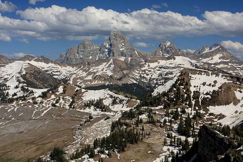
![Teton Range from the West]() Teton Range from the West
Teton Range from the West
We “rested” some more by riding the road bikes ~45 miles around Teton Valley and up Ski Hill Road to Grand Targhee. The climb to Targhee was much more enjoyable (and much less traffic) compared to the steep grades on Teton Pass. We shared the descent with several longboarders who were taking advantage of the smooth pavement and relative lack of vehicles.
Day Six: Green Lake (Jedediah Smith Wilderness)
We wanted to do a hike in the more remote northern reaches of the Jedediah Wilderness. Green Lake is accessible from the North Leigh Creek TH just a short drive NW of Driggs, ID. Once again, we were the first car at the TH increasing the tension slightly as we were told this section of the wilderness is much heavier grizzly country than the southern Teton Range near Victor (by the way, this was our first time doing any backcountry hiking in grizzly country).
![Green Lake Trail]() Green Lake Trail
Green Lake Trail
After about a mile of forested hiking, the trail breaks out into sage, grass, and wildflower filled meadows as it climbs toward Green Mountain. The trail skirts around the east side of the mountain and drops down a steep snow-filled gully before starting a gradual climb toward Green Lake. Snow cover and melting runoff became heavier about ¼ - ½ mile from Green Lake. With the looks of the snow cover, we wondered if the lake would still be partially frozen over highly disappointing our swim crazy golden retriever. The weather was extremely cooperative today as the sky remained completely cloud free, even at midday. It’s always nice to be able to take your time and not have to worry about beating oncoming storms.
Day Seven: Taylor Basin (Jedediah Smith Wilderness) and Transition Day Drive
There wasn’t time for a long hike today since we had to check out of our cabin by 10am. I opted for a solo hike with one of our dogs while my wife and the other dog rested up. The Moose Creek / Taylor Basin trailhead was only 4 miles from the cabin, making it a logical choice. While it would have been nice to make it up to Taylor Basin and summit the peak, we simply didn’t have time unless we did a trail run. We quickly hiked up just short of Taylor Basin before turning around. The hike was predominantly forested passing through numerous sunflower filled meadows providing great views of the southern end of the Teton Valley.
![Big Hole Mountains from Taylor Mountain Trail]() Looking west from Taylor Mountain Trail
Looking west from Taylor Mountain Trail![Teton Range across Jackson Lake]() Teton Range from Jackson Lake
Teton Range from Jackson Lake
For the drive to Silver Gate, MT and week #2 of our trip, we had two options: drive up eastern Idaho (which I’ve been told is an incredibly scenic drive) and enter Yellowstone National Park through West Yellowstone OR drive through Jackson and enter YNP through the south and then going around Yellowstone Lake. Given the horror stories we heard about YNP crowds and traffic, it was an easy decision to steer clear of the likely circus atmosphere in West Yellowstone.
Day Eight: Slough Creek / Trout Lake (Yellowstone)
The original intention for week 2 was to split our time evenly between Northeast Yellowstone and the Beartooth/Absaroka Mountains outside the park. Unfortunately, major road construction between Silver Gate and Cooke City put a damper on the Beartooth/Absaroka plans as delays would have added up to an hour of drive time each day. Not being too disappointed, we realized there was not a shortage of trails in Northeast Yellowstone to explore in the next seven days.
The Slough Creek trail is popular among both hikers and fishermen and is known for its abundant wildlife. After a 1 mile initial approach, the trail joins the vast expanse of the Slough Creek valley. It is a very wide U-shaped valley punctuated by several large mountains (e.g., Cutoff Mtn) to the north. Other than a couple early morning flyfishermen down in the creek, we had the trail to ourselves. While some may find this “flatter” terrain boring, we were excited to hike in such an open area as we’re used to the almost claustrophobic closed-in feel of the Southern Appalachians. The lightly undulating terrain made it easy to cover a lot of ground quickly. Knowing that we wouldn’t have the time to reach a real destination (e.g., Bliss Pass or Cutoff Mtn), we turned around after about 5 miles.
![Meandering Slough Creek]() Slough Creek Valley
Slough Creek Valley![Slough Creek Valley]() Slough Creek Valley
Slough Creek Valley
Other than numerous sneak attacks by Uinta ground Squirrels and a few mule deer sightings, we were not seeing any wildlife. We chalked it up to the July warmth. About two miles from the trailhead, a pack trip, and later a couple of hikers, warned us about a grizzly bear sow and 2 cubs just off the trail. Sure enough, there was two cubs and their light brown colored mother (no – they were not grizzlies as we had been told) about a mile from the trailhead just on the edge of a meadow. We didn’t get to see much as the momma was in the process of snatching the cubs and directing them deeper into the forest and out of sight.
![Cinnamon Black Bear]() Cinnamon Black Bear
Cinnamon Black Bear![Uinta Ground Squirrel]() Uinta Ground Squirrel
Uinta Ground Squirrel
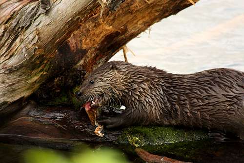
Trout Lake is a very short loop hike around a lake populated by otters who feed on the lake’s abundant cutthroat trout. The lake’s close proximity to the road and the playfulness of the otters naturally draw large crowds (put in perspective - the crowds are nothing like the major YNP attractions). We tried to time a visit during inclement weather to avoid, or at least minimize, other hikers. Unfortunately, our strategy backfired as the otters were not very visible -- probably because an oncoming storm made the lake quite choppy. As the storm became more imminent, we headed back to the car to avoid being a lightning statistic.
Day Nine: Soda Butte Creek Bushwhacking / Lamar River Trail (Yellowstone)
The weather was not cooperative - threatening rain or storms almost constantly. Instead of tackling a longer hike, we decided to explore off-trail, not going more than a mile from the car in case the weather turned south quickly. Several turnouts along the NE Entrance Rd - primarily along or near Soda Butte Creek - provided the perfect launching point for the off trail adventures. We didn’t see anything exciting, but being outside in the spitting rain beat being indoors at the cabin…or even worse…at work.
![Mule Deer Buck]() Mule Deer Buck
Mule Deer Buck![Soda Butte Creek and Barronette Peak]() Soda Butte Creek and Barronette Peak
Soda Butte Creek and Barronette Peak
A trip to Yellowstone would seem incomplete without a wolf sighting – especially considering we were so close to Lamar Valley, the epicenter of wolf activity in YNP. Instead of joining the roadside wolf watchers (there were not as many roadside wildlife viewers as I expected), we took advantage of a break in the weather to do an evening hike down the Lamar River Trail from the Soda Butte TH. It was fairly windy – enough that the main pack of bison had vacated the Soda Butte/Lamar area to congregate at the base of Amethyst Mountain out of the strong west wind. After 1-1.5 miles, the Lamar River trail leaves the flat valley and starts a gradual climb up the Lamar River drainage. The wind became quite excessive at this point – probably sustained 25-30mph. Given the late evening hour and strong headwind, our chances of a grizzly encounter were increasing. Bear spray would have been completely ineffective in these winds. We headed back while watching some wolf researchers with radio antennas bushwhack up the slopes on the south side of the valley. Just the appearance of the researchers meant we were in the right area to see a wolf.
![Soda Butte Creek Black Bear]() Soda Butte Creek Black Bear
Soda Butte Creek Black Bear![Abiathar Peak and Amphitheater Mountain]() Abiathar Peak and Amphitheater Mountain
Abiathar Peak and Amphitheater MountainDay Ten: Trout Lake (again) and Pebble Creek (Yellowstone)
We decided to make another assault on Trout Lake. Knowing that most casual YNP tourists don’t get up at the crack of dawn, we opted for an early start. The strategy paid off as we shared the whole lake with only one fisherman and of course, the otters. While we have seen otters in Fontana Lake in Western North Carolina, we’ve never been able to watch them for extended periods of time. We were able to watch a mother otter and three pups for nearly 30-45 minutes. They are extremely playful and almost seem to crave the attention. When we decided to let them be and continue our hike around the lake, the otters followed us and continuously went onshore ahead of us to play. It’s easy to see why this lake is so popular.
![River Otters]() Trout Lake River Otter
Trout Lake River Otter
The weather today was still somewhat threatening. We hiked from the Warm Creek trailhead up and over the ridge towards Pebble Creek. The hike over the ridge provided awesome views of Abiathar Peak to the south and eventually Cutoff Mountain to the north. There was a lot of bear scat on the way up although none of it appeared to be from recent days. It was enough to keep us alert as, once again, there was no other human activity on the trail. We later came upon two wolf tracks while descending the north side of the ridge toward Pebble Creek. The tracks were pretty fresh as it had just rained. Due to the size (4-5 inches top to bottom), they were too large to be coyote. Given the trails location to the park boundary (~3 miles), it’s possible the tracks were from a domestic dog, but probably unlikely. Instead of continuing down the Pebble Creek drainage (the next section would have gone through numerous burned areas), we headed back to the Warm Creek TH.
![Pebble Creek Trail]() Pebble Creek Trail
Pebble Creek Trail![Abiathar Peak s Ridge]() Ridge leading to Abiathar Peak
Ridge leading to Abiathar PeakDay Eleven: Specimen Ridge (Yellowstone)
Specimen Ridge is a classic YNP point-to-point hike offering expansive 360 degree views and abundant wildlife. We knew we weren’t going to do the full hike – we only had one car and the Lamar River ford was still too high. The trail is almost entirely out in the open going through sagebrush meadows. The early miles of the trail offer great views south of Mt Washburn and the Beartooth and Absaroka Mountains to the north and east.
![Bison and Mt Washburn]() Bison on Specimen Ridge
Bison on Specimen Ridge![Swainson s Hawk]() Swainson's Hawk
Swainson's Hawk
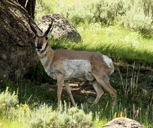
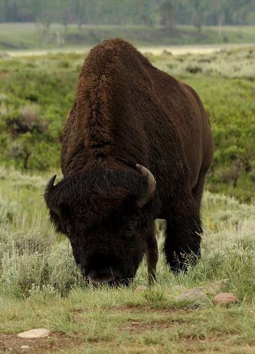
We turned around about 5 miles in – well short of the trail highpoint on Amethyst Mountain (~mile 12). The “trail” gets much harder to follow after about 4 miles as the game paths see much more use than the human footpath. Highlights included many neat glacial erratics high on the ridge, bighorn sheep, a neat vantage into the Yellowstone River Canyon, a large herd of grazing pronghorn antelope, and a very large herd of bison with 30+ newborns on a plateau above the Agate Creek drainage. We did have to yield the trail to a couple of very large bull bison, giving them an extra wide berth. The hike was also not short on birds of prey as we saw numerous bald/golden eagles, ospreys, and hawks.
![Glacial Erratics on Specimen Ridge]() Glacial Erratics
Glacial Erratics![Pronghorn Antelope]() Pronghorn Antelope
Pronghorn AntelopeDay Twelve: Lamar Valley / Lamar River Trail (Yellowstone)
Since it was our second to last day and we had not seen a wolf, we decided to employ a somewhat unnatural approach (for us at least) – get up early and watch over Lamar Valley from the roadside. While we thoroughly enjoy chance wildlife encounters from the roadside, we get much more personal satisfaction being in the backcountry and seeing it in a more natural setting. Personal convictions aside, we were going to be Yellowstone road tourists this morning. Surprisingly, there were not as many people out here as I expected (in fact, there was hardly anyone!) – especially for mid July in YNP! Not much wildlife activity at 5am. At 530am, we watched a lone black wolf running near the treeline on the far side of the river near the Petrified Tree area. We’re sort of glad that it was a black wolf, because it was just far enough away that it may have been hard to differentiate a gray wolf from a coyote. Shortly thereafter, we were able to watch a grizzly for about 30 minutes run up the valley furiously digging in several locations. With our wolf objective met and traffic starting to pick up, we decided to quit while we were ahead.
![Lamar Valley]() Lamar Valley
Lamar Valley
Later in the day, we hiked back up the Lamar River Trail to the Cache Creek Trailhead. We watched a grizzly on the other side of the Lamar River as we hiked up valley. Fortunately, he was far enough away to not be a concern at the moment. The approach to Cache Creek was loaded with wildflowers and was once again mostly hiker free. We did come across 4 fishermen who had encountered a grizzly 3 miles up the trail, but since we were turning around at Cache Creek, we wouldn’t be going that much further. We were once again hoping to see a wolf in the backcountry, especially since the rangers were speculating that one of the wolf packs had just moved to a new rendezvous site somewhere near the Cache Creek drainage. Unfortunately, hiking in the middle of the afternoon seriously diminished our chances and as you would expect, there were no wolves out at midday.
![Bison]() Bull Bison
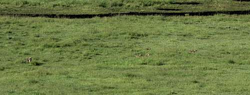
Bull Bison![Coyotes in Lamar Valley]() Coyote Pack
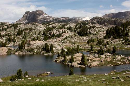
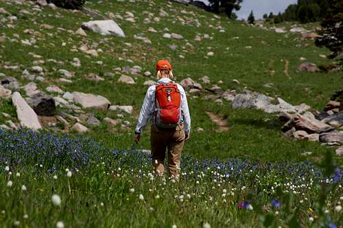
Coyote PackDay Thirteen: Beartooth High Lakes (Absaroka Beartooth Wilderness)
This was sadly our lone hike in the Beartooth high country. We picked a loop to maximize what we could see – hiking up the Beartooth High Lakes Trail, heading over to Claw Lake, then over to Beauty Lake, and back to the trailhead at Beartooth Lake. The hike left us somewhat disappointed that we had not spent more time in this area. The scenery was stunning and is probably even more amazing as one hikes deeper into the wilderness. This set the stage for what will almost certainly be a return visit.
![North End of Beartooth Butte]() Beartooth Butte
Beartooth Butte![Beartooth High Lakes]() Beartooth High Lakes
Beartooth High Lakes![Hiking through Wildflowers - Beartooth High Lakes]() Hiking through Wildflowers
Hiking through Wildflowers![Index and Pilot Peaks]() Index and Pilot Peaks
Index and Pilot PeaksTrip Conclusion
We thoroughly enjoyed our first trip to the Greater Yellowstone area. We were utterly amazed by the vastness of the region. Sure there are some areas overcrowded with human activity, but it really doesn’t take much effort to completely avoid them. Despite being in some of the busiest national parks at a time of peak visitation (July), we saw very few people in the backcountry (Cascade Canyon in GTNP was the lone exception). We were able to see an incredible amount with simple dayhikes, however we realized this area is much more conducive to overnight backcountry excursions to really appreciate its true wilderness qualities. We will definitely be back in the future!
A couple side notes:
For those of you wondering about the dogs while we did all the Yellowstone hikes, don’t worry. They still got to hike every day along the Bannock Trail in Silver Gate. The trail leads through the North Absaroka Wilderness to the YNP boundary. We managed to avoid an encounter with a large blond grizzly that had been spotted several times that week in a meadow just off the trail.
Mosquitoes were generally not a huge problem in the Teton Range. They were however a nuisance in the NE Yellowstone vicinity. We only had one hike in week #2 (Specimen Ridge) that could be done in short sleeves. Hikes on the Bannock Trail in the North Absaroka Wilderness were the worst with us having to don hooded raingear on several occasions just to escape the skeeters.
My wife was insistent on getting a SPOT for the trip solely for the 911 feature. I decided to play with the device sending “OK” messages at various points along our hikes. Since we did not have internet access during the trip, I had no way of immediately verifying the messages. At the conclusion of the trip, I was disappointed to see the accuracy rate for the “OK” messages was only about 80%. Unfortunately, this does not make me feel confident that the device can be relied on in a true emergency.
Other Trip Summary Tidbits
Miles hiked: 115 (includes many inconsequential short hikes with the dogs near our cabins)
Miles ridden: 120 (road – 86; mountain – 34)
Elevation gained: 30,440 feet
Miles driven: 5,000
Wildlife seen: Black bear, grizzly bear, wolf, mink, red fox, marmot, coyote, red fox, bison, elk, pronghorn antelope, mule deer, river otter, Uinta ground squirrel, golden mantled ground squirrel, ruffed grouse, blue grouse, osprey, golden eagle, bald eagle, various hawks. The mere presence of grizzlies and wolves gives this area much more of a real wilderness feel.
# of times we had to yield the trail to wildlife: 6 (bison 5; moose 1)
# of tourists we thought were going to get gored by a bison: 1 (we watched a motorcyclist walked to within 10 feet of a bull bison at the Lamar River TH)


Comments
Post a Comment