Page Type Page Type: Mountain/Rock
Location Lat/Lon: 46.70110°N / 12.43050°E
Additional Information Elevation: 8467 ft / 2581 m
Sign the Climber's Log

Overview


Geographical Classification : Eastern Alps > Carnic Alps > Carnic Alps Main Ridge (West) > Hollbrucker Spitze
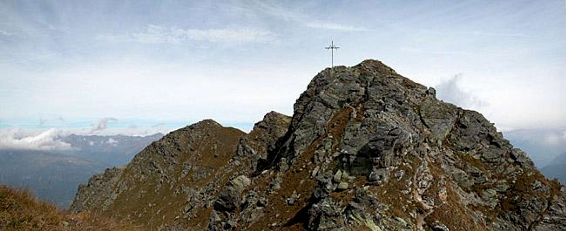
Hollbrucker Spitze photo_id=112683

Hollbrucker Spitze (Cima di Pontegrotto in Italian) is one of the westernmost summits of the Carnic Alps Main Ridge. In fact you will find Helm, Füllhorn and Hochgruben farther west, but all these summits are rather smooth hills which barely draw your attention. Hollbrucker Spitze is no exception but together with its side summit Hollbrucker Eck, which is located some 500m to the north it forms a very fine ridge with an exposed traverse - quite fun, if exposure isn't a problem for you. The ridge goes on to the north towards Zenzer Spitze and is the first (or westernmost) northern side ridge of the Carnic Alps.

The main attraction of Hollbrucker Spitze is its closeness to the Sexten Dolomites. On a fine day you have a fine close-up view of Elferkofel, Cima Bagni, Dreischusterspitze and Haunold. To the north the view reaches far into the Hohe Tauern Range, to the northeast the Lienz Dolomites show their vertical faces. Our own climb to the mountain was a little disappointing - though the Sexten Dolomites were at our fingertips we only saw single parts through the clouds which kept rolling over the ridge.

Being located on the border between Austria and Italy Hollbrucker Spitze and the surrounding summits are located on the Word War I frontline. On both sides of the border the trails still exist, over which the supplies were carried to the front positions. In fact the whole area is a web of trails: One running along the Austrian side, one running along the Italian side and one running along the border. The first two often touch upon fortifications from the war, ruined forts, caves and trenches. At Hochgränten Pass (see the corresponding route) there is a war cemetery - the highest one in the Alps (2429m) - overlooking a heart shaped lake. Here Austrian and Hungarian soldiers have been buried with their pioneer equipment on display.

Getting There


Western Main RidgeWest Central Main RidgeCrode dei LongerinPeralba - Chiadenis - AvanzaEast Central Main RidgeBiegengebirgeKellerwand - Hohe WarteMooskofel GroupRinaldo Group
Interactive map of the western part of the Carnic Alps Main Ridge. The numbers refer to the respective subgroups as given on the Carnic Alps Main Ridge (West) Page. Click on them to get the subgroup description. Hollbrucker Spitze is located in the centre of subgroup 1.

The best starting point for an ascent of Hollbrucker Spitze is the village of Hollbruck south of the Tyrol Gailtal Valley. The village is a small, but touristy hamlet, which can be reached by a side road from Kartitsch.

From the West (Brenner Motorway A22)
Leave the Brenner Motorway near Brixen / Bressanone and follow SS49 to the east through Pustertal / Val Pusteria. To the east of Innichen / San Candido you cross the Austro-Italian border and follow the road (now B100) to Tassenbach. Turn right (south-east) here onto B111, which you follow in direction Kartitsch. Shortly before you reach Kartitsch a side road turns off to the right, which will lead you to Hollbruck. Park your car in the village, both ascent routes start here.

From the North
There are two possible roads:
  • From Kitzbühel over B108 through the Felbertauern Tunnel to Lienz, then southwest to Tassenbach (B100), where you turn on to B111 east into the Tyrol Gailtal.
  • From Salzburg along motorway A10 to Spittal. Turn west on B100 to Oberdrauburg, there south to Kötschach-Mauthen were you turn east on B111. You need to go through the whole Lesachtal Valley to reach Kartitsch. Shortly afterwards turn to the left to Hollbruck

From the South (Udine)
Take Motorway A23 to the exit Camia Tolmezzo. Follow SS52 north to Tolmezzo where you turn onto SS52 bis. This leads to Plöckenpass, where it crosses the Austro-Italian border. In Austria the road turns into B100 and at Kötschach-Mauthen you have to turn east on B111 into Lesachtal Valley. Again, go on through the whole valley to Kartitsch.

Red Tape


Hollbrucker Spitze photo_id=112701

There is no real red tape to be found. Meadows are used for extensive grazing of sheep and cattle so you should close gates after you. The mountain is located on the Austrian-Italian border so it might be a good idea to have an ID-card handy. I never had to show mine but the boundaries still exist, even in unified Europe.

When To Climb


The mountain can be climbed all year round. In effect the ascent route along Zenser Spitze is used for ski tours. The steep ascent to Hollbrucker Eck and the exposed ridge traverse to Hollbrucker Spitze are probably out of the question in winter. Here you should go the longer way which circumvents Hollbrucker Eck.

Accommodation


In most of the villages of the area there is a small campground, which in most cases is associated with an inn or hotel. If you are looking for hotel rooms or apartments follow one of the links below

Weather Conditions


In general the weather in south-eastern Austria is much better than in the northern and western parts of the country. Europe mostly is covered by western winds and the clouds from the Atlantic have to climb over the Alpine Main Ridge before they reach East Tyrol or Carinthia. So much of the humidity is left somewhere else… Still, as you can see from the pictures, weather is far from certain so keep yourself informed by one of the links below

Maps 'n' Books


Maps
I have been using maps by Kompass Verlag, which are very good for the hiking trails though they don't show ALL the relevant summits of the area.
  • Lienzer Dolomiten / Lesachtal
    1:50000
    Kompass Map WK47
    Kompass Verlag
    ISBN: 3-85491-053-3
  • Gailtaler Alpen / Karnische Alpen / Oberdrautal
    1:50000
    Kompass Map WK60
    Kompass Verlag
    ISBN: 3-85491-067-3

As for books please look at the corresponding section of the Carnic Alps page.


Children

Children

Children refers to the set of objects that logically fall under a given object. For example, the Aconcagua mountain page is a child of the 'Aconcagua Group' and the 'Seven Summits.' The Aconcagua mountain itself has many routes, photos, and trip reports as children.