
-
 19301 Hits
-
 88.19% Score
-
 26 Votes
|
|
Mountain/Rock |
|---|---|
|
|
47.58758°N / 11.06023°E |
|
|
Hiking |
|
|
Spring, Summer, Fall, Winter |
|
|
4403 ft / 1342 m |
|
|
Overview
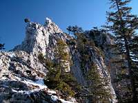
 Kofel
Kofel Ridge to the summit
Around the beautiful city of Oberammergau, there are several impressive mountains like Notkarspitze or Teufelstättkopf and Laubeneck. All of the mountains there are higher than Kofel. But the steep walls and its Matterhorn-like shape make this small mountain quite unique. It is the unquestioned eye-catcher and often called the "Matterhorn of Oberammergau". It' s quite airy summit offers spectecular views down to Oberammergau and the surrounding mountains.
The hike to the Kofelsteig is steep but beautiful leading through a splendid forrest. After reaching the Kofelsattel the views start to get spectecular since you' re climbing the steep walls of Kofel. The climbing is very easy and well secured with chains. If there are several people on the mountain (which is usually the case) you have to be careful of falling rocks from other people. On bright sunny days on summer weekends expect to meet lots of people climbing Kofel.
Since Kofel is not very high and the hike quite short you' re able to ascent and descent it easily within 3-4 hours. If you don' t want to get down that fast you may choose Königssteig to climb a peak of the beautiful Sonnenberggrat ridge or the complete ridge towards Pürschling. If you do that you have a nice day trip with beautiful views into the heart of the Ammergau Alps.
Maps and routes overview
 On the ridge.
Maps:
- KOMPASS #5 Wettersteingebirge Zugspitzgebiet
A good overview map, which also covers the area around Oberammergau. - KOMPASS #05: Oberammergau und Ammertal
A more detailed map of the Ammergauer Alps around the city of Oberammergau. - Map #8432 - Oberammergau
A detailed map of the area is #8432 Oberammergau of the Bayerische Landesvermessungsamt München.
Routes:
- Kofelsteig
Starting at the parking lot outside of Oberammergau (about 840m/2755ft), many zig-zags lead up to Kofelsattel (1215m/3986ft). From there the Kofelsteig leads up to the summit. This very easy via-ferrata is not difficult and only at very few sections exposed. As said before the ascent is quite short. You reach the summit within about 2h from Oberammergau.
Summit view
  |
Mountain Conditions
Webcams:
- Webcam at Romanshöhe.
View direction directly towards Notkarspitze (background). Kofel is the rocky peak on the right. The city of Oberammergau visible in the foreground.
Weather:
- www.wetter.com (Oberammergau)
Weather forecast of Oberammergau. - OEAV weather
Weather forecast of the austrian club of the alps (OEAV). - Avalanche report of Bavaria
Unfortunately this page is in german only.
Getting There
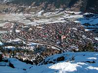 Oberammergau from above
The route to Kofel starts at Oberammergau. There are several possibilities to get there.
- By car:
Road B23, which connects Schongau with Oberau runs through Oberammergau. From Oberau you have access to Garmisch-Partenkirchen and to the highway to Munich.
There is a parking lot at the trailhead. I think it is free, but I don' t know. The parking lot is outside of Oberammergau. - By train:
Oberammergau has a train station with a train leaving about every hour to Murnau. From there you have trains to Munich, Innsbruck and Ehrwald/Füssen(Austria).
To get to the trailhead from the train station of Oberammergau you have to follow the street leading into the city. Shortly after leaving the train station you reach a bridge over the river Ammer. You have to follow the river (watch out for signs to Kofel). After a while you leave Oberammergau and a trail leads to the right into the forrest and to the trailhead.
Red Tape
| There are no fees, permits or seasonal closures. Kofel is part of the nature reservation area Ammergau Alps which is the biggest nature reservation area of Bavaria. Therefore you should leave only footprints on the mountains and do not leave the trails. If you' re lucky you will see some chamois crossing... |  Chamois on Kofel Chamois on Kofel |
Accomodation
Oberammergau is a touristic area with several hotels and places to stay. There is a camp ground at the foot of Kofel.
For more information visit the multilangual homepage of the area.
When to climb
Since Kofel is very popular and the ascent doesn' t last very long it is climbed very often the hole year. The best chance to find the summit not completely overcrowded is during the week.
During the summer months reaching the summit isn' t difficult. The rocky part at the end is well secured and not difficult at all. In winter you have to deal with snow and ice which may make the final ascent quite tricky.
External Links
- www.oberammergau.deMultilangual homepage of the area of Oberammergau. Lots of information about places to stay and activites
Page history
| 13/Jan/2008 |
|