
-
 2164 Hits
-
 78.27% Score
-
 9 Votes
|
|
Mountain/Rock |
|---|---|
|
|
47.54100°N / 10.94184°E |
|
|
Hiking, Mountaineering |
|
|
Summer, Fall |
|
|
6627 ft / 2020 m |
|
|
Overview
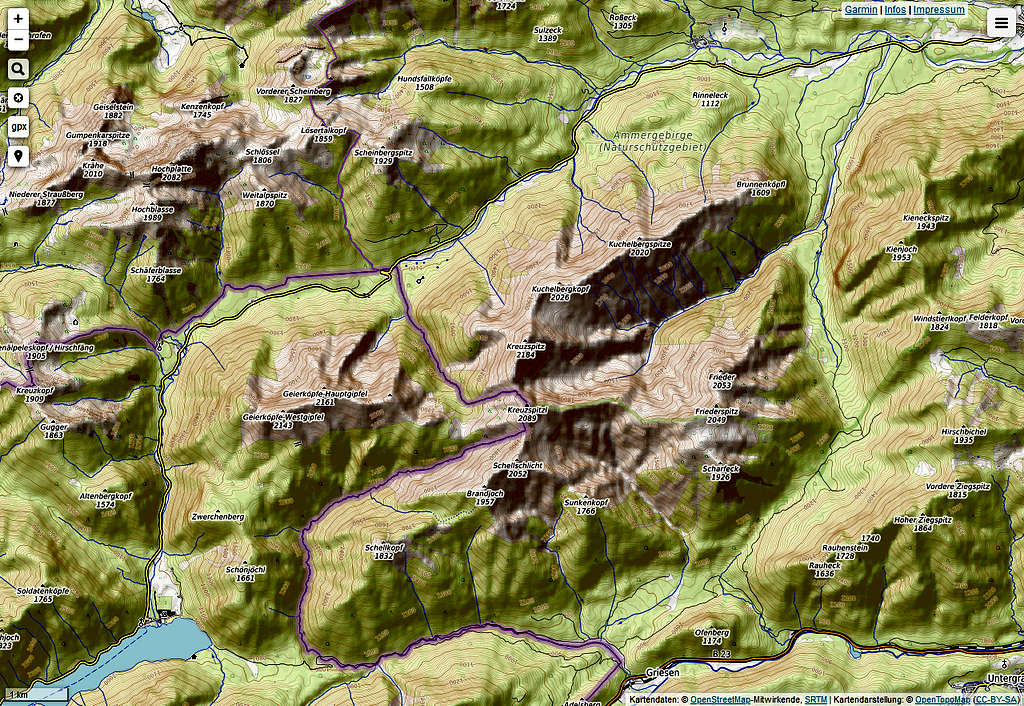
South of the famous royal castle of Linderhof you can see a long and high ridge culminating in Ammergauer Kreuzspitze summit, one of the highest peaks of Ammergauer Alpen. The northeastern part of this ridge hosts two other, lower and less spectacular summits, Kuchelbergspitze and Kuchelbergkopf, the latter being the slightly higher elevation. Kuchelbergspitze and Kuchelbergkopf invite, together with a climb to Kreuzspitze, to a long and interesting hike and traverse.


As these two summits are not far away from each other and are not very prominent, I describe them together in one article.
Kuchelberg ridge separates the lonely Kuchelbach valley to the south from Graswang – Linderhof valley to the north. Kuchelbergspitze is the eastern summit of the ridge, Kuckelbergkopf the western one, neighbouring mighty Kreuzspitze.
The traverse of Kuchelberg ridge to Kreuzspitze is a very nice traverse, the route leading through Kuchelbach valley to the summits can be combined with the traverse to a great and long loop route.
Getting There
Best trailhead are two hiker parking areas along road number St 2060 near Linderhof castle.
The eastern one is called Fürstenweg parking area between the village of Graswang and Linderhof, the second one is an unnamed parking area about 500 meters in front of the road junction to Linderhof castle.
You reach these trailheads by car
From Munich direction go on highway A 95 and road number B 2 to Oberau. Turn on road number B 23 to Ettal monastery. After the monastery and village turn on road number St 2060 to Graswang and to the parking areas.
From Füssen / Reutte direction leave Austrian road number 179 at exit "Reutte Süd” and follow road number L 255 to Plansee, Ammerwald and to the border to Germany at Linderhof. Go on road number St 2060 shortly to the two parking areas.
Public transportation:
The next railroad station is at Oberammergau. Bus number 9622 goes from Oberammergau to Linderhof.
Routes Overview
From both trailheads take the forest road in the direction of the valley south of you. Both forest roads unite and run south, entering Elmaubach valley.
500 meters after a triangle shaped road junction a trail leaves the road to the right at the end of a clearing and in the shadows of a huge tree. Follow the zigzag trail up to Kuchelberg forest service hut (water) and to the Kuchelberg ridge. Ascend the ridge to the summit of Kuchelbergspitze. Descend slightly following the ridge crest trail and ascend again to long Kuchelbergkopf.


Alternatively follow the forest road to its end and climb the trail to the saddle between Kuchelbergkopf and Kreuzspitze. Turn right and follow the ridge trail to Kuchelbergspitze, crossing Kuchelbergkopf summit.
Both routes form a loop route; Kreuzspitze can be reached easily from and back to the saddle.


A very long, difficult and strenuous traverse is the following one: trailheads – Frieder north ridge (no trail) to Frieder (UIAA grade I in parts) – traverse to Friederspitz – ridge from Friederspitz to Kreuzspitzl (Österreichische Kreuzspitze) (no trail, in parts UIAA grade II in frail rock) – traverse to Kreuspitze (one part UIAA grade II, great traverse in better rock) – saddle – Kuchelbergkopf – Kuchelbergspitze - trailheads. Allow 10 to 12 hours for this.


Red Tape & Accommodation
Kuchelbergspitze and Kuchelbergkopf are part of the huge nature protection area “Ammergebirge”.
There are, however, no special regulations for this area.


Next village with accommodation is
Nearby are:


There are no mountain huts in this part of Ammergauer Alpen.
Gear & Mountain Condition
Kuchelbergspitze and Kuchelbergkopf are easy hiking summits. They are accessible from late sping to early winter, depending on the snow conditions. Partly the trails are not marked and narrow. The ridge is easy to walk. Good shoes and hikers gear is sufficient.
The long traverse from Frieder, however, is a difficult and very long undertaking and should not be underestimated. Walking in off-trail terrain and ability to climb UIAA grade II in frail and unstable rock and a good orientation is vital.


Weather condition Linderhof:
Maps
DAV-Map, scale 1 : 25000
Number BY7
Ammergebirge Ost, Pürschling, Hörnle:
Trails and ski routes, UTM grid,
edition 2015
together with
DAV-Map, scale 1 : 25000
Number BY6
Ammergebirge West, Hochplatte, Kreuzspitze:
Trails and ski routes, UTM grid,
edition 2017

