
-
 1451 Hits
-
 77.48% Score
-
 8 Votes
|
|
Mountain/Rock |
|---|---|
|
|
Summer, Fall |
|
|
6854 ft / 2089 m |
|
|
Overview
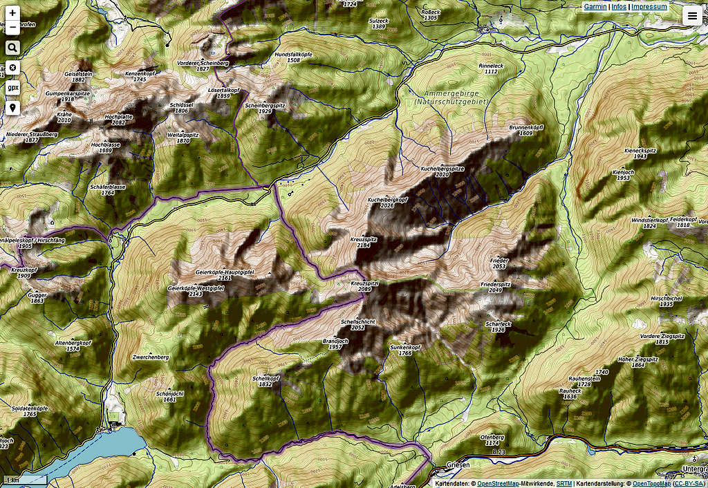
A long, north – south running rocky ridge links Ammergauer Kreuzspitze to Schellschlicht, two well known and often visited peaks of Ammergauer Alpen. In the very middle of this ridge sits another summit, which is called Kreuzspitzl, the little brother of Kreuzspitze, or “Österreichische Kreuzspitze”, as this peaks unlike its big brother, sits on the German-Austrian border.
")
")
Kreuzspitzl receives far less visits comparing to the neighbor summits. Nevertheless this summit can be part of some very interesting traverses in this part of Ammergauer Alpen. It is a lonely lookout in a wild and lonely landscape.
Kreuzspitzl is the crossing point of two ridges: the Kreuzspitze – Schellschlicht ridge and the Geierköpfe – Frieder / Friederspitz ridge, the latter running west – east. Lonely valleys and cirques, mostly without any trails, are bordering this summit: Kreuzkuchel to the northeast, Schellkar to the southeast, Schellental to the west and Neualpl to the northwest.
The main part of Kreuzspitzl lies on german territory. The west slopes and the uppermost parts of the ridges to Kreuzspitze and to Schellschlicht belong to Austria as the border makes a strange bend to the east.
Getting There
Best trailhead is the hiker parking area “Bei den 7 Quellen”.
You reach this trailhead by car
- From Munich direction go on highway A 95 and road number B 2 to Oberau. Turn on road number B 23 to Ettal monastery. After the monastery and village turn on road number St 2060 to Graswang, Linderhof and to the parking area at the German – Austrian border.
- From Füssen / Reutte direction leave Austrian road number 179 at exit “Reutte Süd” and follow road number L 255 to Plansee, Ammerwald and to the parking area at the border to Germany.
")
")
Public transportation:
The next railroad station is at Oberammergau. Bus number 9622 goes from Oberammergau to Linderhof. There is, however, no bus connection to the trailhead.
Routes Overview
Direct route:
From the parking area “Bei den 7 Quellen” go south to the scree fan coming down from Neualpl valley. Head south and reach the start of the Neualpl trail on the west (orographic left) side of the valley. Ascend the beautiful trail to Neualpl col. Take the left hand trail there climbing up the west ridge of Kreuzspitzl to the summit.
")
")
")
There are three traverse routes; the first one can be combined with Neualpl route to a days loop:
Traverse Kreuzspitze – Kreuzspitzl
Climb Kreuzspitze best on the northern normal route, which starts, too, at the parking area “Bei den 7 Quellen”. From the summit follow the first sharp and exposed south ridge; one difficult short part is secured with a steel chain. Cross the southern subsummit and descent on rock and scree on the south ridge to the col between Kreuzspitze and Kreuzspitzl. Ascend steeply the first part of Kreuzspitzl north sidge; there is a steep slab – UIAA grade II – the most difficult part of the route. Leave the rocks on a short ledge and ascend on a narrow trail back to the north ridge and up to the summit.
")
")
")
")
Traverse Schellschlicht - Kreuzspitzl
Ascend Schellschlicht summit on one of the two southern normal routes. Leave the summit to the north, climbing down a short but steep rock step. Follow the narrow foot tracks along the connecting ridge sometimes on its eastern side avoiding some rock towers, to the west ridge route from Neualpl and to the summit.
")
")
Traverse Frieder / Friederspitz – Kreuzspitzl
Difficult off-trail traverse in partly bad rock, UIAA grade II in some parts, epic and rarely done. A real challenge.
")
")
Red Tape & Accommodation
The German part of Kreuzspitzl is part of the huge nature protection area “Ammergebirge”.
There are, however, no special regulations for this area.
")
Next village with accommodation is
Nearby are:
There are no mountain huts in this part of Ammergauer Alpen.
Gear & Mountain Condition
Kreuzspitzl is an advanced hiker summit. It is accessible from early summer to early winter, depending on the snow conditions. The Neualpl route follows narrow but good trails. Good shoes and hikers gear are sufficient.
The traverses from Schellschlicht or Kreuzspitze require some scrambling and climbing abilities in short rock parts. These traverses are scarcely marked (some cairns) and in short parts exposed.
The traverse from Frieder / Friederspitz is a difficult and long undertaking and should not be underestimated. Navigating off-trail terrain and ability to climb UIAA grade II in frail and unstable rock and a good orientation is vital.
")

Weather condition:
Maps
DAV-Map, scale 1 : 25000
Number BY6
Ammergebirge West, Hochplatte, Kreuzspitze
Trails and ski routes, UTM grid
edition 2017
")
")