
-
 6418 Hits
-
 76.66% Score
-
 7 Votes
|
|
Area/Range |
|---|---|
|
|
46.28418°N / 13.77304°E |
|
|
Hiking, Scrambling, Skiing |
|
|
Spring, Summer, Fall, Winter |
|
|
1500 ft / 457 m |
|
|
Overview
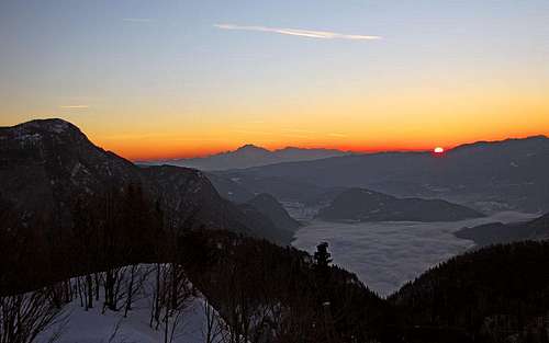 What a scene to start the day! Sunrise from near Dom na Komni.
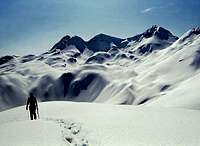
Bohinj area is characterised by a wreath of nice mountains, by its big glacial lake, the charming Valley of Triglav Lakes - and a high plateau, named Komna. The latter one became a synonim for a high, karst plateau of Julian Alps. This is the place more for romantic souls, not so much for competitive, sport characters. Especially in winter and early spring, when you slide on skis across an endless, sunken in snow landscape. Yes, it might happen that then you suddenly realise that mountains are not only high steep walls and sharp peaks, but also soft, remote areas, in which you leave your trail only for a short period of time, and then it gets swept by the wind forever. If we compare Komna with other areas of Alps, then it is similar to the areas like: Totes Gebirge, Hochschwab or Steinernes Meer, to mention only a few.
On the south, Komna is bordered by the mountains of South Bohinj Range. In long arc they steadily turn towards the north-west and end on Bogatinsko sedlo (Bohinjska Vratca). North of this saddle the hilly Lanževica rises. It starts the long ridge of mountains, which continues towards the north and borders later on the western side also the Valley of Triglav Lakes. Actually, Komna is smootly passing into the Valley of Triglav Lakes, the border between the two areas in nowhere sharply set. Zgornja Komna (Upper Komna) is often treated as a part of the Valley of Triglav Lakes. East of Komna and some 1000 meters lower, there is the deep, glacial Bohinj Valley with its big lake. The three bigger regions of Komna are: Zgornja Komna on the north, Lepa Komna in the middle and Spodnja Komna southernmost. Let us see them a bit more in detail.
Spodnja Komna
From the mountains of South Bohinj Range some unimportant side ridges are deterring towards the northeast. But they soon lower on a more plateau-like area, with altitudes around 1500 m. The centre of it is Planina Govnjač, 1475 m. This alpine meadow is not live any more. What you can see there are only remains of stone barracks from the World War I. Around its basin there are a few hills, which are some 100 m higher, the whole area is in summer very much overgrown with pine bushes, among which the highest larches are growing. From Govnjač, towards the west a high valley called Dolniki is rising, ending finally below the Bogatin summit. Northern slopes of the hills above Govnjač are then lowering into the high valley Gracija, which forms the border to Lepa Komna. On the very east of Gracija, two popular mountain huts stand.
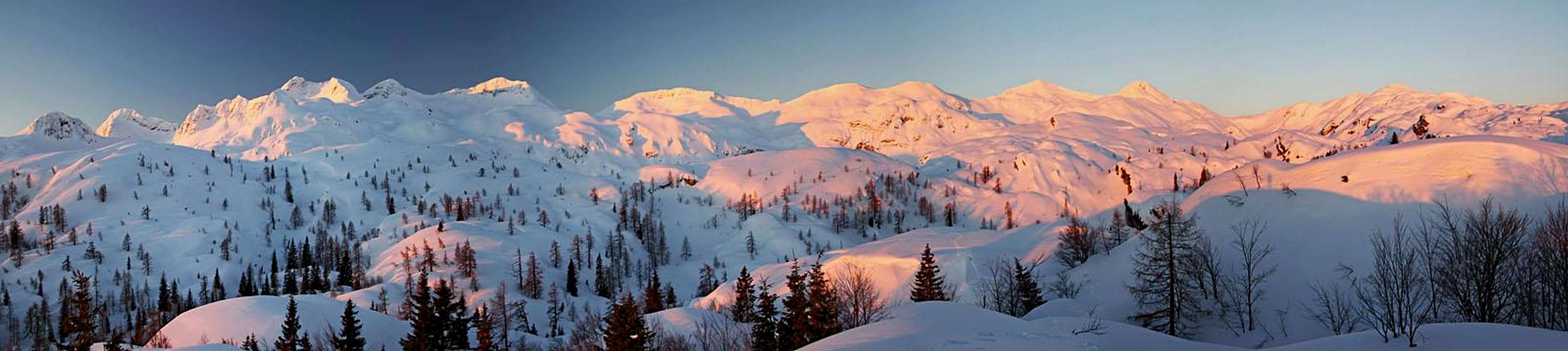 The western part of South Bohinj Range from before Dom na Komni
Lepa Komna
 Lepa Komna
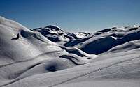
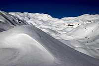
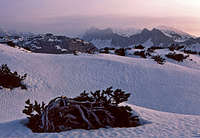 On Lepa Komna
In winter this is perhaps the most beautiful part of Komna (Lepa means in Slovenian language Nice). Above Gracija valley a ridge of hills stretches from Lanževica on the very west, over Vrh nad Gracijo to Srednji vrh. More towards the east this ridge has only insignificant bumps above the plateau. So, north of the mentioned ridge, on the altitude of some 1600 m Lepa Komna stretches. Its eastern part is just a broad plateau, while on the western part, a valley called Poljanica was formed. Once there was also an alpine pasture, today the area is abandoned. On the west, Poljanica is already bordered by the high ridge, which goes from Lanževica on Kal. The western part of Komna is closed by the rocks of Kal massif, lowering towards the east to the place, where once Planina Na Kalu (meadow) was.
Zgornja Komna
This broad and much higher area lies north of Lepa Komna and west of the Valley of Triglav Lakes. The upper Lopučnica valley was also once a broad pasture, from it a very overgrown, hardly passable karst slopes are rising towards the west to the main ridge and north towards the high summits of Plaski Vogel and Veliko Špičje.
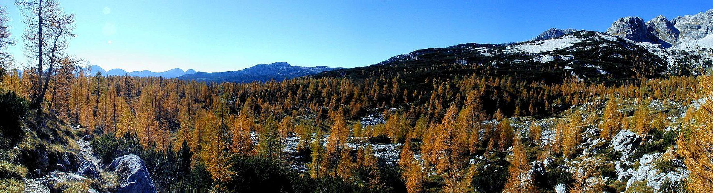 Autumn on Zgornja Komna
Getting There
The most natural approach on Komna plateau is of course from Bohinj valley. We can drive till the westernmost end of it, where by Koča pri Savici, 654 m, there is a big parking place (to be paid in summer). From there a good, broad mule track brings you up on Komna in 2 h 30 minutes. As the hut is supported by a material cable way, you can put your backpack on it. But it often operates only on a request, so it is not the cheapest one. Other approaches on Komna are much longer. You can get there also from Vogel resort, from Planina Razor, from Lepana valley, from Planina za Skalo and from the Valley of Triglav Lakes.
Komna Tours
A Few Summer Hikes
1. From Dom na Komni, 1525 m, on Bohinjska Vratca, 1803 m, then from the saddle left on the South Bohinj Range. We follow the mountain crest as far as we wish. From those summits we shall be able to descend to the hut in some 2 hours, then we need less than 2 more hours to the valley. The path across Komna is easy (T1/T2), by the ridge some sections are medium hard (T2/T3).
2. From Dom na Komni, 1525 m, on Bohinjska Vratca, 1803 m, and further to the west to Krn lake or even on the summit of Krn. Long, but easy tour. Some 6 h, T2.
3. From Dom na Komni, 1525 m, into the Valley of Triglav Lakes and then down in Bohinj (actually, it is more nice in the opposite direction). A bit more demanding (T3) is the passage down over Komarča wall.
4. If you like to get lost on broad karst plateaus, you can try an ascent on one of the summits north of Lanževica.
View Komna in a larger map. This map shows only ski tour routes (clicking on a blue line will give you the name of a ski tour, not the name of the place). Warning: The summer paths on this Google map are drawn upon not realiable resources. Many of those paths may not be existing!
Komna Ski Tours
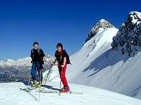 On Konjsko sedlo
1. Triglav Tour Ski Main Line. This route crosses Komna as well. Actually, this is more a travel across high plateaus, with only a few higher downhill slopes in Triglav group. On Komna it comes from Vogel ski resort and is marked by high (up to 5 m) poles. It enters Komna area on Konjsko sedlo (saddle), 1782 m. From there we slide down towards the NW, then cross the northern slopes of Vrh nad Škrbino towards the W, cross the broad saddle between Podrta gora and Mohor, 1848 m, and then turn northwards (don't do that too early!). Through the valley of Tolminska Lakev we reach the plateau above Govnjač and then slide towards the W into its basin. From Govnjač we continue towards the NE (a bit up and down) to Dom na Komni. From Konjsko sedlo to the hut 2 h 30 min to 3 h. Medium hard ski tour.
 Towards Triglav Lakes in 1972
2. Komna - the Valley of Triglav Lakes. This is continuation of Triglav Tour Ski Main Line. From Dom na Komni you shortly descend towards Bohinj, but already on the first crossroads deter left. You ascend a flat shoulder and continue northwards across the plateau. A short descent brings you in a small Razor valley, then soon on Planina Na Kalu, 1636 m. Then you continue below Kal and descend into the upper Lopučnica valley, 1535 m. There the route turns right (eastwards). With a few turns you ascend the broad ridge and slide on the other side into the Valley of Triglav Lakes. 3 hours, easy. To Planina Na Kalu you can get also from Koča pod Bogatinom. You follow the route on Lepa Komna and towards Poljanica, but in the middle of the plateau deter right (northwards) to the slopes of Kal and then right on the meadow (take care of orientation!).
3. Podrta Gora. This ski tour is hard and steep. From the upper part of Tolminska Lakev you ascend steeply towards the S-SW, finally reaching the notch between Podrta gora and its western fore-summit (Mali vrh, 2015 m). To ascend the summit of Podrta gora, 2061 m, you need a full winter equipment.
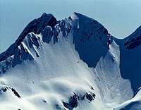 Podrta gora ski tour
4. The Notch Below Zeleni vrh. From Govnjač you go by the tour on Planja saddle (see #5 below!). But from below the saddle you continue towards the SE on a small plateau below the main ridge and in the same direction on the notch 1975 m, east of Zeleni vrh. The final part of ascent is very steep (picture on the right)!
5. Planja Saddle. From Govnjač basin you go towards the west and only then turn left, towards the south. Through a steep passage (ravine) you reach the plateau east of Kser, 1900 m, and north of Vrh Planje, 1971 m. Then continue towards the SE on the broad saddle between Vrh Planje and Tolminski Kuk (2085 m). This is a medium hard ski tour. The ascent on Tolminski Kuk requires a full winter equipment.
6. Kser Saddle. Between Kser, 1900 m, and Vrh Planje, 1971 m, there is a broad saddle, which can be a goal of a nice ski tour. The same approach as in #5, but after we pass the summit of Kser, we deter right on the saddle. Medium hard ski tour.
 Below Mahavšček
7. Dolniki. This is a quite easy ski tour, which can be combined with the ascent on either Mahavšček or Bogatin. We ascend by the main route (through Gracija valley) towards Bogatinsko sedlo. Some 50 meters below the saddle we deter left, towards the south, and cross the eastern slopes of Bogatin. After reaching the small saddle, we can already start the Dolniki ski descent. We are sliding gently towards the SE and only at the end a more steep valley step brings us down into Govnjač basin. If we want a summit, for more skilled skiers Mahavšček is the right choice. When we are NE of it, we deter right and ascend on the saddle between it and Bogatin. The final ascent (either by the main ridge or by the northern slope) is very steep. But it is likely that for skiing you will have already some soft snow there. Also Bogatin can be done with skis - by the western slope. After a steep summit descent you continue either towards Mahavšček or towards the north on Bogatinsko sedlo.
8. Lanževica from Bogatinsko sedlo. This is an easy, classical Komna tour. A good track usually goes from Dom na Komni to Koča pod Bogatinom and further above the valley of Gracija. If there is a danger of avalanches or in very poor conditions, you should better keep down, by the bottom of the valley. Otherwise the track crosses the slopes of Srednji vrh and Vrh nad Gracijo and with a few final turns reaches Bogatinsko sedlo, 1803 m. A great panorama on Krn group opens there. From the saddle we continue northwards. The ridge over Vrh nad Gracijo to Lanževica is broad and easy. Ascent altogether: 2 h 30 min.
 Lanževica above Lepa Komna
9. Lanževica Over Lepa Komna. This is a very nice, easy tour over a wonderful plateau. At Koča pod Bogatinom you deter right from the main track and ascend a distinct saddle in the NW directen. Then you continue crossing Lepa Komna on the altitude of some 1600 m. When reaching Poljanica meadow, you turn left and start ascending towards the SW. The track aims the saddle between Vrh nad Gracijo and Lanževica, but usually just before reaching it, turns right, crosses the gentle eastern slopes of Lanževica and then ascends the summit by the north ridge. 2 h 30 min. From Lanževica it is also possible to ski down by the north ridge and then descend on Poljanica from Oslova škrbina (saddle).
10. Kal. Till Poljanica the tour is easy. There we continue in the northern direction, towards Mala Vrata saddle. But before reaching it, we deter right and over steep slopes ascend a small saddle between the two summits of Kal. Then left on the highest point. It's a medium hard ski tour (upper part), but the steep slopes are often not covered by hard snow (southern exposition). 2 h 30 min.
11. Čelo. A very nice, but quite hard tour on a high summit above Zgornja Komna. The tour is often done over the Kal summit (see #10 above). The descent on the connecting ridge goes from the small saddle between the two summits of Kal. Those slopes are steep, north oriented (hard snow) and in places intermitted with rocks. Then you continue in the vicinity of the main ridge on Velika Vrata, 1924 m. From that broad saddle you continue northwards. If enough snow, the tour is not hard till Glava za Bajto, 2131 m, the southern fore-summit of Čelo. From there to the main summit, the slope is very nice, but steep, so it requires quite some care. The summit of Kal can also be detoured. In that case we continue the ascent from Poljanica on Mala Vrata, descend some 15 meters from that saddle towards the NW, and then follow a ledge, which brings you behind Kal again on the main ridge. The passage is steep! And the third option how to reach Velika Vrata saddle is through the passage of Brinje. By the route towards the Valley of Triglav Lakes you go till Planina Na Kalu, 1636 m. There you enter into the valley which ascends east of Kal massif - always in the NW direction. In the upper part it brings you on the hilly plateau of Brinje, lying east of the main ridge. Continuing in the same direction you get just below Velika Vrata. A nice option for skiing down.
12. Dom na Komni - Bohinj. This is quite an easy ski descent if there is enough snow. Otherwise it can be challenging to do all those turns on the mule track. Some parts of the forrest are also steep, so don't get too much speed there. See the page of Dom na Komni for route description (in ascent)!
Frost Hollows On Komna
On Lepa Komna one of the frost hollows is called Mrzla Komna (Cold Komna). In January 9th, 2009 the lowest temperature in Slovenia was measured there. The temperature dropped on an inconceivable level of -49.1 degrees celsius. That is the place which can be also crossed on the tour on Lanževica - it is very close to the normal route.
Mountain Huts
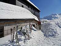 Dom na Komni Dom na Komni |
 Koča pod Bogatinom Koča pod Bogatinom |
 Koča pri Triglavskih jezerih Koča pri Triglavskih jezerih |
|
When To Visit Komna?
You can visit this nice place any time of a season. The hut is always opened. But by far the most beautiful season in winter and early spring.