
-
 19309 Hits
-
 73.06% Score
-
 3 Votes
|
|
Hut/Campground |
|---|---|
|
|
46.28442°N / 13.77333°E |
|
|
Spring, Summer, Fall, Winter |
|
|
5010 ft / 1527 m |
Basic Information
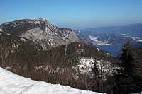
The view down into Bohinj
The hut is standing on the south-eastern edge of Komna plateau, high above the valley of Bohinj. It was built by Slovenian Mountaineering Association in 1936. During the World War II it was burnt and then rebuilt in 1948. Later it was many times renewed, last time in 2005.
The hut is an excellent starting point for tours on the summits around Komna high plateau, and also for long distance trecks such as towards the Valley of Triglav Lakes, towards Krn lake and over the long range of South Bohinj mountains. From the vicinity of the hut one has very beautiful views: down in Bohinj valley with the big lake, on the rugged summits of Podrta gora group, across Komna plateau and on the summits above the Valley of Triglav Lakes. This makes the hut worth of hike for itself.
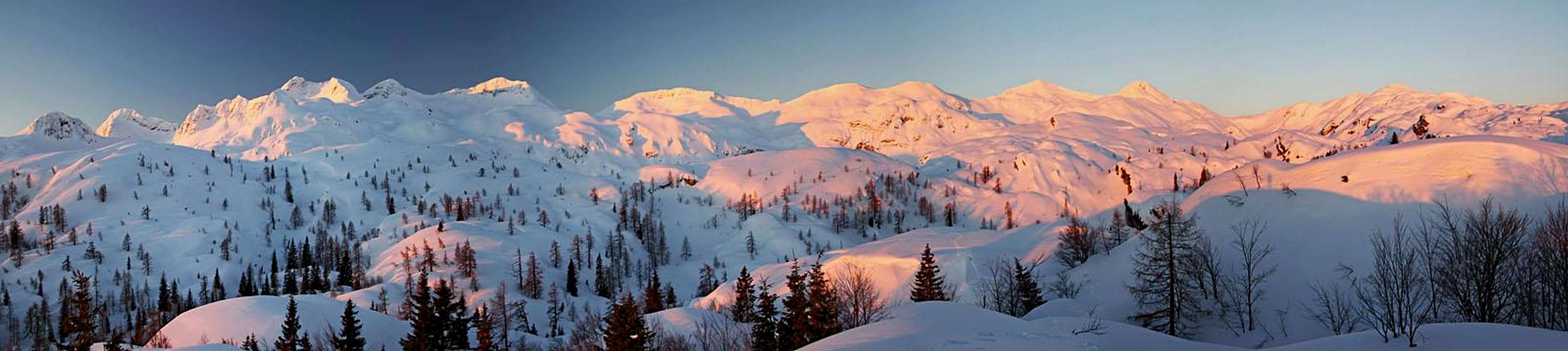 The western part of South Bohinj Range from before Dom na Komni
The hut is opened through the whole year. In 21 rooms there are 74 beds and additional 34 places to sleep in common rooms.
Managed by: Planinsko društvo Ljubljana-Matica.
Tel.: +386 40 620 784.
E-mail: komna@pd-ljmatica.si
Access Routes
From Koča pri Savici
The normal, shortest approach comes from Bohinj valley by a well-beaten, easy mule track. But due to a considerable altitude difference it still requires from an average hiker 2 h 30 min of endurance.
From the big parking place (in summer toll) the marked path first goes only slightly ascending along the creek of Savica. But soon after the tourist path branches right across the creek towards the famous waterfall, our path starts ascending in many switchbacks. They say it is 48 of them. Through beech woods they bring us into the lower part of Pekel valley. Till there only on a few places wies open down towards the big lake and on Pršivec slopes across the valley. In Pekel the path flattens and then starts ascending again by the right slopes of the valley (looking up). We go paralelly to the valley. On one turn we see ahead of us the hut. It looks close, but due to its size we still need some 30 min till there. After a few turns the path reaches the crossroads, where another path branches towards the right - towards Črno jezero. We go straight and the next branching is where another path goes right towards the hut in the Valley of Triglav Lakes. We keep left again and ascend over the last steep slope to the hut.
This path is also used for skiing down. Skiing is nice when there is enough snow on the path, otherwise it requires some additional skills.

Bark beetle art
Times:
> Ascent in summer: 2 h 30 min.
> Ascent in winter: 2 h 30 min to 3 h.
> Descent in summer: 2 h.
> Skiing down: 1 h to 1 h 15 min.
Other approaches to the hut are much longer (frtom Lepena, from Planina Za Skalo, from Vogel, etc.).
Summits and Passages
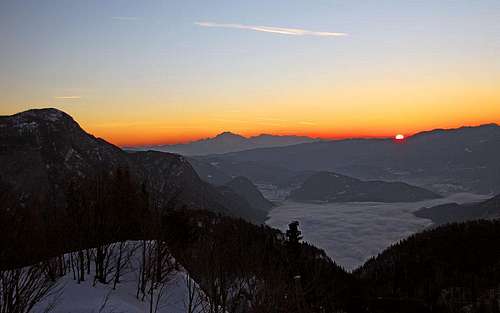
Sunrise from near the hut
From Dom na Komni you can do the following tours:
Summits
Bogatin (1977 m), 1 h 45 min (easy, marked path).
Mahavšček (2005 m), 2 h 15 min (easy, marked path).
Lanževica (2003 m), 2 h (easy, marked path).
Tolminski kuk (2086 m), 3 h (medium hard, marked path).
Vrh nad Škrbino (2054 m), 3 h 30 min (hard, marked path).
Vogel (1923 m), 3 h (easy, marked path).
Ski Tours
Too many to mention them all. Most people go on the summits of Lanževica, some on Kal or even Čelo, nice, but much steeper are the summits of South Bohinj Range. Nice are many crossings of Komna plateau, crossing towards the Valley of Triglav Lakes or the tour on Krn (very long).
Passages
Koča pod Bogatinom (1513 m), 15 min (easy, marked path).
Planinski dom near Krn Lakes (1385 m), 2 h 45 min (easy, marked path).
Dom dr. Klementa Juga in Lepena (700 m), 4 h 15 min (easy, marked path).
Koča pri Triglavskih jezerih (1685 m), over Kal meadow, 2 h 30 min (easy, marked path).
Koča pri Triglavskih jezerih (1685 m), by Črno jezero, 3 h (easy, marked path).
Koča pri Savici (653 m), 2 h (easy, marked path).
Koča na planini Razor (1315 m), 5 h (medium hard, marked path).
Planinska koča Merjasec on Vogel (1537 m), 5 h (easy, marked path).
External Links
In Slovenian language: https://www.pd-ljmatica.si/koce/komna/