
-
 4633 Hits
-
 81.84% Score
-
 14 Votes
|
|
Route |
|---|---|
|
|
40.26214°N / 9.45876°E |
|
|
Trad Climbing |
|
|
Spring, Summer, Fall, Winter |
|
|
Most of a day |
|
|
Alpine D+, UIAA V+ |
|
|
17 |
|
|
Overview
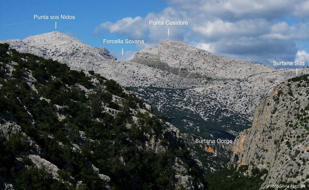
Geographical classification: Sardegna - Sardinia > Supramonte > Punta Cusidore > Legione Reale Truppe Leggere
Legione Reale Truppe Leggere, Punta Cusidore NW Ridge
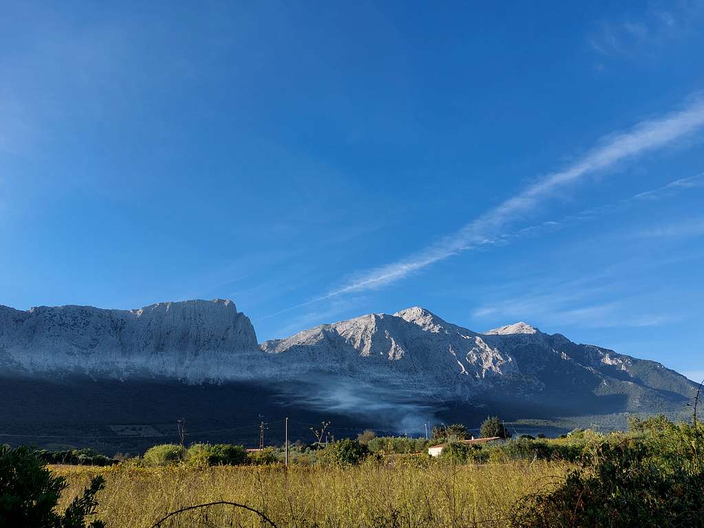
The Supramonte Massif is one of the best known mountain area on the isle of Sardinia. It's a group made of steep limestone walls and beautiful hard rock climbs, both classic and modern. The rocky heart of this very wild kingdom is the majestic peak of Punta Cusidore, a wonderful mountain. King of Supramonte, Punta Cusidore also represent the symbol of mountaineering in Sardinia.

It's a veritable pearl located between Bruncu Nieddu on the left and the summit of Pedra Mugrònes on the right, along an extensive karst ridge overlooking and dividing the valley of Lanaitto and the plain of Oliena. It's quite famous in reason of its stunning North-West and West walls, dropping up to 600 meters in the highest point. Among the over 30 routes climbed on these two walls the greatest classic route and one of the most famous of Sardinia is Legione Reale Truppe Leggere (Royal Legion Light Troops), a wonderful line running up the clear North West edge of the mountain. The rock is a whiter limestone of excellent quality.
Getting There
The closest towns are Oliena and Dorgali.
Road access
Access from Oliena - Take the road to Dorgali; at the junction with the road to the church of Montserrata (km. 2,8, branch not very visible, signposts anyhow) leave the main road and turn to right towards the sanctuary.

At the first junction after about 100 meters take the branch to the left, a narrow road winding in the direction of the walls. After another 600m turn right and head directly for Punta Cusidore. At an intersection the road turns left again and you follow it for another 600 m. Here the asphalt ends and the road becomes unpaved, rising between the vineyards and leading you to a little fountain named Funtana Iscandula, altitude 200 m. Further on the road becomes bumpy and it's advisable to park your car as you find a pull out, unless you have a four wheel drive.
Route Description


Legione Reale Truppe Leggere, Punta Cusidore NW Ridge – report UIAA scale
Summit altitude: m. 1147
Difficulty: D+, UIAA V+
Equipment: bolted belays, some pegs along the pitches
Climbing length: 620 m
Exposure: North-West
First ascent: Emilio Beber, Carmelo Andreatta, Giovanni Cagnati 1973, October 1st
Starting point: Pedra ’e Littu
A great outing on a highly satisfactory classic route, providing an exciting climbing up a ridge on excellent white limestone. A classic route of Supramonte Massif. Despite the most difficult moves don’t exceed the grade V+ (UIAA scale) it’s not a route to be taken lightly, especially in reason of its length: 17 pitches and 620 meters of climbing development


Walking approach – From the parking continue on the bumpy road at first uphill as far as until the beginning of the forest, then take the right road mainly on level getting to the big boulder called Pedra 'e Littu (30 minutes from the car). From the boulder a gravel path (white-red signs) heading to the wall gets the scree coming down from the NW edge. Still following the trail reach the base of the rocks (1 hour from the car). The start is located at a ridge that borders a small amphitheater, signaled by a written and a sign

Route report
L1 - Climb the ridge along a beautiful crack and belay on the rocks above in the middle of the pillar (50 m, a move grading IV +)
L2 - Climb up easy rocks and stand on a tree slightly to the right of a large detached block (50 m, III).
L3 - Climb the block (IV), coming out on beautiful slabs above. At this point, the original route isn't obvious and there are different variants followed. This report describes presumably the route by the first climbers, having been found some wooden wedges. This route is sometimes avoided on the right, along a dihedral crack grading V
L4 - Climb the slabs a bit to the left, belaying on a tree at the base of a small corner (50 m, IV).
L5 - Climb the small corner exiting right, then a nice crack slanting left (pegs and wedges) reaching the trees on a ledge (50 m, IV and V).


L6 - Climb some easy rocks to the base of a sharp crack belaying on a tree (50 m, III). Probably the first climbers avoided the following three pitchs to the right, crossing for 45 m of rocks mixed with grass, linking the itinerary described below near the summit of the pillar. The first climb of the variant that is described below (which is also the crux of the route) is claimed by Corrado Pibiri and Bruno Poddesu during their 1980 first repeat.
L7 - Climb the large crack (V +) and belay at the bottom of dihedral-chimney (30 m, V +, IV).
L8 - Climb a step and then up the dihedral, exiting right by climbing an overhang on a slanting slab (25 m, V and V +, various pegs).
L9 - To the left keep again the crack that soon becomes less difficult and belay as soon as possible on outcrops (50 m, V, IV).
L10 - Continue to the right to overcome the summit section of the pillar, climbing some beautiful little walls of excellent rock and belaying on a sloping slab on top of the first step (50 m, IV).


L11 - With a characteristic move pass on a narrow saddle (peg) and go up cracks and ridges (omitting to the left the difficult and large bolted crack of the route Amicizia). Belay on a narrow ridge (50 m, III, IV a single move).
L12 - Along the edge up to the base of a beautiful crack with tree. Climb the crack and the next wall next up on top of the ridge (50 meters, IV + and then IV). (From here it's possible a fuga along the abseil of "Cuore di Pietra", on the northern side: mark on an outcrop with sling, necessary 2 x 50 m ropes).
L13 - Easily on the ridge to a saddle (50 m, II and III).
L14 - Here starts the last section of the route, climbing a ridge that becomes a dihedral, but it must be left almost immediately to traverse to the left on a narrow frame, leaving on the right the route Amicizia that continues straight. Belay on the north wall (25 m, V).
L15 - Up again on a diagonal cracks a bit grassy to the ending gully (50 m, IV and V). Without a compulsive route to the summit (50 m, III).


The timing of the climb are variables: to skilled climbers trained and familiar with this type of route it may take 5 to 6 hours. However, this route has become a frequent destination for parties often at their first experience in alpine climbing; there have been frequent cases of bivouac or even helicopter withdrawals. It is good that they provide a full day of climbing.
Descent description


Descent - The descent is mainly a scramble.
From the summit scramble down towards South (a short move graded II UIAA), getting the base of the rocks. Head to West (towards right facing out) to reach the saddle between Cusidore and Pedra Mugrònes named Forcella di Sovana. From the saddle scramble down a steep scree to the base of the NW ridge route and from here follow the path to Pedra 'e Littu, then the dirty road to the parking (about 2 hours from the summit).
Essential Gear
Ropes 2x50, helmet, small and medium friend, nut, slings for the numberless holes. Hammer may be useful
Red Tape
There are not particular restrictions in hiking and climbing inside this area; no fees and no permits required.
Supramonte is a wild setting lying inside Parco Nazionale del Gennargentu e del Golfo di Orosei. The territory of the park belongs to the Nuoro, Ogliastra and Cagliari provinces and had been established in 1998. Its 73.935 hectares' extension includes 18 communes: Aritzo (NU), Arzana (OG), Baunei (OG), Belvi (NU), Desulo (NU), Dorgali (NU), Fonni (NU), Gadoni (NU), Gairo (OG), Oliena (NU), Orgosolo (NU), Seui (OG), Seulo (CA), Talana (OG), Tonara (NU), Urzulei (OG), Ussassai (OG), Villagrande Strisaili (OG).
When to climb
All year round. Anyhow in reason of the length of the climb best period goes from April to October

Accomodation
Several possibilities of every kind of accomodation in Dorgali and Oliena
Meteo
Guidebooks and mpas


"Pietra di Luna - Trad & Multipitches" - Maurizio Oviglia - V updated edition Fabula 2015
"Sardegna" - Maurizio Oviglia - Guida dei Monti d'Italia Club Alpino Italiano - Touring Club Italiano 1997 Map - IGM 50.000, sheet "Oliena"