
-
 80081 Hits
-
 95.1% Score
-
 53 Votes
|
|
Area/Range |
|---|---|
|
|
40.11000°N / 9.07000°E |
|
|
Hiking, Sport Climbing, Bouldering, Big Wall, Canyoneering |
|
|
Spring, Summer, Fall, Winter |
|
|
6014 ft / 1833 m |
|
|
1 - Overview
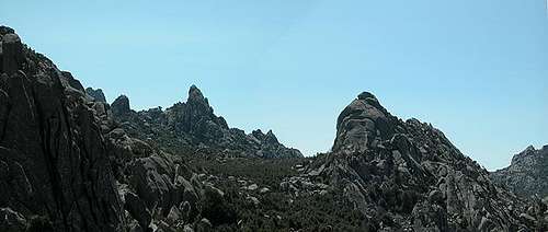
 Punta Maggiore (970m) and Punta lu Castedàcciu (828m) Punta Maggiore (970m) and Punta lu Castedàcciu (828m) |
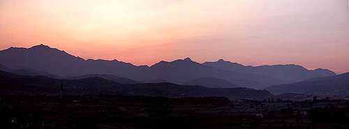
Sardegna or - as most of the world calls it – Sardinia is the second largest island in the Mediterrenean Sea reaching a bit more than 24000 square km. When talking about the island I cannot help but must compare it to its northern neighbour, Corsica. Both Islands share much of their geological and political history, they share a common – or at least very similar language and both are popular vacation destinations for the outdoor crowd.
But while I never had doubts about adding Corsica and its mountains (fifty 2000ers!) to SummitPost I felt reluctant at first to add Sardinia’s. A short glance at Sardegna’s map will suggest to you that the island consists of a large high plateau which drops into the sea at some of it edges. The average elevation is some 400m with seemingly few mountaintops rising above 1000m. The Monti di Gennargentu might be the exception with Sardinia’s highpoint, Punta la Marmora reaching a whooping 1833m. Moreover there don’t appear to be large mountain ranges, rather an assortment of mountain clusters, all of them only covering an area of several 10 or 20 square km. That perception couldn’t be more wrong.
Yes – mountains don’t reach elevations like their neighbours on Corsica – but they make more than up for it by their form and appearance. There are the limestone mountains of Supramonte, Monte Albo and the Isola di Tavolara, which all culminate in huge vertical north faces, most of which are perfect climbing spots, some of them rivalling even the best known spots in the Dolomites. There are the canyons and Gorges through Supramonte Costiera, again built from limestone with numerous towers, spires and rock windows.
While here you can find unspoilt climbing walls, getting to them is quite an experience. There are the climbing spots along the east coast, huge walls dropping directly into an emerald green sea. In the north – on Monte Limbara you find an assortment of beautiful granite domes, again perfect for climbing. This area has been set aside completely for free climbing. In the far north in Gallura Province you find the weathered granite rocks, called Tafoni – and here the similarity to Corsica’s Calenche couldn’t be more pronounced. In the west of the island there is the long volcanic chain of Montiferru, Marghine and Gocéano and in the south you find the mountain ranges of Iglesiente and Monte Lattias.
The lower overall elevation and the southern location ensures better weather on Sardegna than on Corsica, resulting in many more varieties of plants, insects, lizards and birds. The many karst high plateaus are virtually covered in Peoniae, St. Pankratius Lilies, Cyclamen and various orchids. After all it is hard to tell which of the two islands is the more beautiful. I myself lean towards Sardegna but the race is close. Though Corsica and Sardegna share the geologic history both seem to complementaries of each other. Both have a solid granite foundation but on Sardinia it only shows in the far north of the island while on Corsica all of the 2000ers are made up from granite. However, limestone is abundant, especially in the east and south and that again is in stark contrast to the small region of the “Corsican Dolomites” in that island’s south. On Corsica the lowest region – the alluvial plain in the east is made schist while on Sardinia you find this kind of rock only in the highest mountain range, the Monti di Gennargentu.
2 - Sardegna on SP
  |
- The East Coast
- Costa Smeralda, Gallura and the North
- The West Coast
- Sardegna’s South
3 - The East Coast
Sardegna's highest and most impressive mountains can be found on its east coast. While the highest mountains in the Gennargentu Range are made up out of schist the remainder of the area is solid limestone. For the latter the rock quality differs from very rotten (like on Monte Corassi) to perfect (like on Punta Cusidore), sometimes within an area of just one sqare kilometre. Mainly the whole area is a huge high plateau cut through by numerous creeks and rivers, often forming deep gorges in the porous limestone. The following subsections describe the main mountain areas and their specifics.
3.1 - Monti del Gennargentu
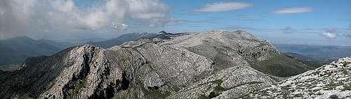
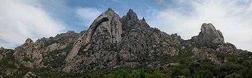
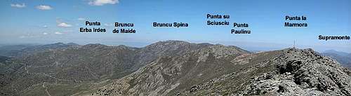 The highest summits of the Monti del Gennargentu
Sardinia's highest mountain range, the Monti del Gennargentu, is a very lonesome region, which has only one access road between the mountain towns of Fonni and Désulu. Far from being very rugged, the mountains resemble green hills, barren of almost all vegetation. The timberline reaches some 1400m which is very low for a mediterrenean island, located around 40° latitude (in fact the 40th parallel cuts through the range between the highest summits). The reason for the barrenness lies in the fact, that in the 18th and 19th centuries most of the oak forests of the island were cut down to produce something as prosaic as - charcoal.
Today only the remnants of charcoal kilns and old mule trails - mulaterias -tell of this history. The mulaterias serve as hiking trials, especially near the coast, where the limestone rocks of Supramonte and the undergrowth otherwise would block every way. Some of the trails follow ingeniously constructed paths into the coastal gorges. The Baccu Maore Gorge is one example. All of Sardinia's highest mountains are located within a small area at the centre of the Monti del Gennargentu. The ridge that connects them forms a half circle, open to the west. Except for the southern coast, the whole island can be seen from the ridge, sometimes - on very clear days - the view reaches Corsica to the north and the Italian mainland to the east.
3.2 - Supramonte
 Supramonte north faces
The Supramonte Mountain Range is Sardinia's / Sardegna's second highest one. It is formed by limestone rock, which is is quite similar to the formations you can find in the Dolomites. in fact the mineral composition is very similar, the limestone being a special kind of Dolomite. The range, however, is older so that it is in a state of advanced erosion. You won't find the large scree piles beneath the summits, that you get used to in the Dolomites - most of them have been grown over and are pretty easy to ascend.
The Dolomite resemblance is most striking from afar - look at the north or west faces and you can feel relocated to the Pale di San Martino Group. There is a large high plateau which is bounded by huge drops towards the Oliena plain some 1000m below. The north faces are famous for long and difficult climbing routes. Punta Cusidore and Bruncu Nieddu attract serious climbers for nearly vertical climbs for between 350 and 500m. The west faces are too eroded to be climbed but below them - on Monte Maccione - there is one of the most famous climbing locations, with more than 70 routes with difficulties between difficulties from UIAA VI through X.
3.3 - Supramonte Costiera
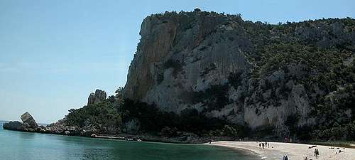
 Pietra Longa and Punta Argennas (710m)
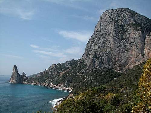
Lower than high Supramonte, the Supramonte Costiera is a high plateau which rises directly out of the sea. It is covered by oak and pine forests and cut through by deep gorges. Baccu Maore and Codula della Luna are two of these canyons, both stretching from the sea deep into the back country. They are framed by overgrown vertical walls which close in to form very narrow pathways in many spots. Directly on the coast you find some of the most beautiful climbing spots on earth, big walled mountains like Punta Giradili or Punta Argennas form the backdrop but the most popular spots ar at Cala Goloritzé, Cala Luna and Cala Gonone. The climbing walls and towers rise directly out of the emerald green sea.
3.4 - Isola Tavolara
 Isola Tavolara
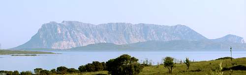
Speaking of mountains rising directly out of the sea mention must be made of Isola Tavolara, a 5km long and 1km wide island of the east coast of Sardinia. Its faces rise vertically out of the sea culminating in a 564m high highpoint. Geologically it is closely related to high Supramonte and Monte Albo, in fact having formed one large area in former ages. The regions drifted apart, however and today more than 50km separate them. Isola Tavolara is (or was) Europe's smallest kingdom - in 1838 it was granted sovereignity by the then Sardinian King Charles Albert. The monarchy was revoked for a short period by the end of the 19th century but since then it has been the official form of government of the island. King Carlo II "rules" a handful of permanent residents, but generally the island is represented by the Italian republic.
3.5 - Monte Albo
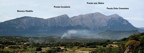
 Monte Albo seen from Punta Cupetti
The Monte Albo mountain range in Sardinia / Sardegna is one of the most spectacular regions of the island. It stretches for a little more than 20km between the towns of Lula and Siniscola. The overall direction of the chain is WSW to ENE. Monte Albo is composed of white limestone, which is responsible for the name (Pale or White Mountain). Though closely related to Supramonte to the south (see above), the Monte Albo rock is far more eroded so that climbing locations can only be found in isolated spots. I have seen a couple of (newly) bolted routes near the saddle Janna Nurai in the southwest of the group. Monte Albo defines itself by the impressive north faces which drop some 400m into the high plain between Lula and Passo Santa Anna.
There are only three possible ascent routes onto the mountain range, all of which follow deep cuts in the north faces. The top of Monte Albo is a high plateau and it is here that the resemblances to Supramonte are strongest. Though the plain from afar looks like a flat plateau, it is crisscrossed by ravines and gullies which don't appear at the first glance. There are no trails on the plateaus and the hiker has to use his/her own best judgement to reach the destination. I have found it most convenient to hike as close as possible to the north face drops, cince there the underground can be seen and there are no trees and bushes which impede your progress.
4 - Gallura, Costa Smeralda and the North
Sardegna's north is a country of vastly differing aspects. To the west you find the almost flat regions of Nurra, Logudoru and Anglona ranged around the town of Sassari. From a mountaineer's or climber's view the area is unimportant though Nurra offers some fine easy hikes along the coast. Quite different is the large eastern region of Gallura, which stretches from Sardegna's northern tip at Capo Testa almost to Nuoro in the centre of the island. Gallura is the domain of granite of all forms, shapes, sizes and colours. Besides the regular domes you find on Monte Limbara most of the north is made up of grotesque Tafoni formations (see below).
People like to say that Capo Testa is the realm of the 1000 shapes, San Pantaleo is the realm of the 1000 towers and the coast of Costa Smeralda is the realm of the 1000 bays. Costa Smeralda has become the hunting ground of Italy's (and Europe's) rich. You can find beautiful hoses perched above wonderful bays, everything backlighted by the emerald green sea. The area is quite expensive when it comes to hotel rooms, houses or apartments. Quite to the contrary the Gallura backcountry is as remote as it can get. It is the home to countless acres of cork oak forest, one of the main means of income for Gallurans in former time.
Gallura is linked to Corsica by more than the 12km wide Bocche de Bonifacio, the strait between the islands. Galluran Sardinian is closer to the Corsican language than to the idioms of the rest of the island, stating clearly the shared history of Corsica and Sardinia. Both coats of arms show the moor with the white bandana and both populations are fiercely patriotic.
4.1 - Monte Limbara
 Several of the Monte Limbara Domes as seen from the base of Monte Biancu
Sardegna's third highest mountain range, Monte Limbara, is a special place. Dozens of beautiful granite domes are scattered around the mountain range, most of which are good climbing or bouldering destinations. The area is remote though it can be seen from the main northern highway SS597 between Olbia and Sassari. Its highest summit, Punta Ballestreri (1359m), is defaced by countless radio, television and radar antennae but the likes of Monte Biancu, Monte Lisgiu or Torre Littaghesu make more than up for it. Much of the range has been fenced off (thanks now doubt to the radar installations) but can be hiked and climbed nevertheless. Climbing is restricted to "clean climbing" - no new pro allowed to be placed.
4.2 - Tafoni: Punta Cugnana
 Punta di lu Lurisincu (545m), Punta Cugnana (650m), Contra li Mandri (532m)
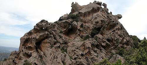
Punta Cugnana (650m) and neighbouring Punta Balbacanu (420m) are typical mountains for the northeastern part of the island of Sardinia (Sardegna). Built from red granite they form bizarre formations due to a typical erosion form called Tafoni (see the section below for an explanation). These erosion forms are typical for the islands of Corsica and Sardinia but of course occur in other places as well. They are a tourist attraction in Corsica where a narrow road winds through one of the most pitturesque regions I know, the Calenche de Piana. Punta Cugnana though not remarkable in height offers some very typical views of the bizarre, masklike formations and is very easily accessible. Climbing these formations sure is fun. You'll be able to reach the tops with class III climbs and there are a lot of bouldering possibilities. Nevertheless the area is not so much known for climbing, probably due to the fact that many of the formations have razor sharp edges. You'll probably better stay back and admire.
4.3 - Tafoni - the typical erosion structures of Corsica and Sardinia
 Swiss Cheese Tafoni
The Calenche is composed of a large variety of strange looking rock formations, all having been formed by ages of erosion. Similar structures can be seen on Sardinia and other places of the world, mostly associated with either granite or sandstone. In Corsica this kind of erosion is called Tafoni, derived from the Corsican word tafonare for "perforate". In most of the cases Tafoni have been hollowed out in a semi circular fashion.
The actual process is a combination of physical and chemical erosion forms. Through capillary forces moisture within the rock is allowed to climb to the surface of the rock. Since the fluids dissolve part or the inner rock structure they can deposit these minerals on the surface which form a very hard but also very thin outside crust. In the course of time the effect weakens (or softens) the inner rock structure while the outside crust gets harder and harder.
Once the crust (mainly iron and manganese oxide) is broken and wind and rain can erode the inner and softer rock, the latter is eaten away rapidly (at least on a geological scale) like the innards of your regular breakfast egg. Since moisture will stay longer and since Evaporation is occurring less on the shadowy northern parts of the rocks the crusts there remain very thin and can get broken much more easily. The whole Tafoni process takes very long and today's Tafonis have been being created since the last ice ages.
 |
 |
 |
 |
5 - The West Coast
The west of Sardegna is of volcanic origin. Quite in contrast to the areas immediately to the south, where you find an abundance of porous limestone, and where you barely find a drop of water the Marmilla Region and especially the high plain of Giara di Gésturi are completely different. Here you find dozens of lakes in cork oak forests. In winter the area becomes one large lake, in summer it dries up so that most water evaporates. But in spring you can find a great abundance of flowers, insects and birds. Western Sardegna also hosts the largest consecutive ridge of the island.
Monte Ferru, the Catena del Marghine and the Catena de Gocáno are all formed of volcanic rock and run from south-west to north-east. A big number of prehistoric Nuraghen dwellings give testimony to the fact that the area has been lived in for a very long time. Capo San Marco and Capo Mannu in the far west offer nice and easy coastal hikes.
6 - Sardegna's South
On the southern tip of the island you find Sardegna's capital, Cagliari. The region is heavily populated and much of the area is agriculturally used. However, the Gulf of Cagliari separates two mountain areas the Sarrabus Range in the east with Punta Serpeddi (1067m) as its highest summit and the Sulcis range to the south-west, culminating in Monte is Caràvius (1116m). A bit further north, already close to the west coast There is the Monte Linas Range (Punta Perda de la Mesa).
6.1 - Sarrabus Range and Sette Fratelli
The south-east of Sardegna, north-east of the capital Cagliari is the area wherE you can find the Sarrabus Range and the ridge of Sette Fratelli. While the former is the (slightly) higher range it is covered in trees (mainly oaks) and offers only few hikes or views. The highpoint, Punta Serpeddi, is an exception since it sticks it's summit out of the canopy. It can be reached on bike by a forest road.
The Seven Brothers, Monte dei Sette Fratelli, on the other hand is a limestone ridge formed of bizarre spires and gendarmes. The summit ridge is open, so that beautiful views are awarded towards Cagliari and the coast. The area south-west of Sette Fratelli is one of the oldest inhabited areas on the island. There are uncountable Nuraghen, the prehistoric houses and fortresses which can be found all over the island but nowhere as dense as here.
6.2 - Sulcis Range
The Sulcis range in Sardegna's south-west - like so many other ranges on the island - is formed of white karst-like limestone. However, most summits stay below the timber line, thus there are only rare views towards the coast. Exceptions are Monte Arcosu (945m), Punta Rocca Steria (1009m) and Monte is Carràvius (1116m). The region is most famous for the nature preserve that the World Wildlife Fund has established in 1986 on its eastern side. The preserve is held privately and encompasses an area of 3600ha. There are guided tours through the preserve and it is open only at times. The preserve houses the last herds of the Sardinian Deer, which was on the brink of extinction when the preserve was founded.
6.3 - Monte Linias
Monte Linias in Sardegna's south-west is a mountain range which closely resembles Supramonte, however on a smaller scale. Elevations are comparable, the mountians look similar in their limestone-whiteness there are canyons and caves - much like all you find in the east. The range is closer to the sea, however so that you have additional perfect views to the coast. The range is made up of two parallel ridges which both run south-east to north-west.
7 - Trekking on Sardegna
 Pietra Luna, one of the most popular climbing spots on Sardegna
In contrast to Corsica, which is trekkers heaven, Sardegna knows only one multiday trekking trail, Sentiero Selvaggio Blu, on the east coast. It is - as trecking trails go - an extreme trail, since it contains passages of grade IV as well as some rappeling. The trail starts at Pietra Longa near Arbatax and runs through all the climbing areas of the east coast - Punta Giradili, Cala Goloritzé, Cala Luna - before it finally ends at Cala Gonone. The average trecking time for the whole trail is eight days. The trail is marked (by blue arrows) but much of it is overgrown so you need a quite good sense (and equipment) for orientation. The parts at the northern and southern ends are the easiest ones. Just simple hiking trails which in some places are overgrown by macchia. Sentiero Italia is another trekking trail, which crosses the islamd from south-east to north-west. The trail is a 1000+km trekk which covers the whole of Italy, with some 200km on Sardegna. It is rarely done in its whole length much unlike Corsica's GR20, which is one of the most popular trecks of Europe.
8 - Getting There and Accommodation
8.1 - By Plane
There are three major airports, one near Olbia in the north-east, one at Alghero in the north-west and one near Cagliari in the south. Olbia and Cagliari are served by regular carriers while Alghero is the destination of the buget carriers. Unfortunately - for climbers - Alghero is as far away from any climbing spot as is possible on an island the size of Sardegna.
8.2 - By Ferry
There are quite a number of ferry ports on the island, the most important of which are Cagliari and Olbia. The following table gives and overview of ports and destinations
| Port | Origins |
| Olbia | Livorno, Civitavecchia, La Spezia, Genova |
| Arbatax | Genova, Civitavecchia |
| Cagliari | Civitavecchia, Napoli, Trapani-Palermo, Tunis, Genova |
| Porto Torres | Ajaccio, Marseille, Propriano, Genova |
8.3 - Accommodation
...is rather easy to find. Since all the interesting mountaineous regions are on the north and east coast - which is where the largest beaches are - you can book hotel rooms and appartments from any tourist office. The region around the towns of Baunei and Tortoli should be the best staying places. Also Cala Golone could be an interesting location. Still quite near to Punta Giradili it also offers a variety of good and interesting climbs
8.4 - Camping
... is also easy to find, especially in the vicinity of the beaches. Look for locations, using www.sardegna.com. Free camping is not allowed in the natural park so you need to consider staying farther away.
9 - Red Tape
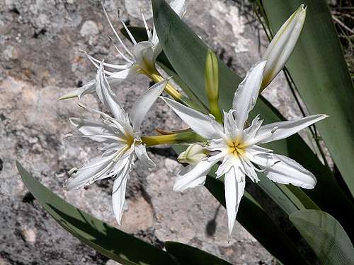 St Pankratius Lilly on Monte Albo
To my knowledge there is only the Natural Park Gennargentu - Golfo di Orisei on the east coast, which has been set aside. The usual restrictions concerning wildlife apply. Within park boundaries camping is allowed in designated areas only. Locals are quite ambiguous about the natural park so don't fear any trouble for environmental reasons. However, much of the area is still private property and free camping definitely is no good idea. Better ask the farmers if you can camp on their lands. Be prepared to pay some €s to smooth things over. As for climbing there is also red tape. While the spots near the coast or on Monte Albo and Supramonte ar unregulated, on Monte Limbara climbing is restricted - no new bolts - clean climbing. Moreover, the area is fenced off thanks to the military installations on Punta Ballestieri.
10 - Weather Conditions
Go for the following link, which is in Italian but with ALL the information you might want to have on weather on the island: www.sar.sardegna.it. Click the weather map for more information.
11 - Maps & Books
11.1 - Maps
There are no current hiking maps - at least I don't know any. I used a 1:200000 car map and the guidebook below.
- Sardinien / Sardinia World Mapping Project Map 1:200000 Reise Know-How Verlag ISBN: 3-8317-7091-3
- Digital map at http://www.pcn.minambiente.it/GN/index.php?lan=en
11.2 - Books
- Sardinia (Sardegna / Sardinien) M. Omidvar Rother Verlag ISBN: 3-7633-4800-X (English) ISBN: 3-7633-4143-9 (Italian) ISBN: 3-7633-4023-8 (German)
- For climbing in Sardinia there is a book, called Pietra di Luna by Maurizio Oviglia, which is available in Italian, English and German. Click on the image to be directed to a web page with more (also ordering) information.
