
-
 28591 Hits
-
 80.98% Score
-
 13 Votes
|
|
Mountain/Rock |
|---|---|
|
|
46.01670°N / 121.75°W |
|
|
5926 ft / 1806 m |
|
|
Overview

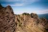
Lemei Rock is the highest point in the Indian Heaven Wilderness Area which is situated in the middle of the diamond formed by Rainier, St. Helens, Adams and Hood. It's a craggy remnant of a volcano whose crater is now Lake Wapiki. This area has incredible views of the above four Cascade Peaks as well as somewhere around 50 smaller volcanoes and vents in this area. There are several trails that will get you to the base of this summit ridge and a few ways to scramble up to the summit. Trail 33 from the north will skirt the base of Bird Mountain on the way to Lemei Rock and you can either continue around to the east side and climb a third class gully on the east face (heading in a southwesterly direction) or bushwhack up the north/northwest ridge (third class, maybe some fourth) and scramble the summit ridge to the top (comes in around 4 miles long). Trail 34 from the east gets you to the east face/crater area and the same gully/small couloir (a bit shorter maybe 3 and 1/2 miles long but steeper trail).
SP member, Bob Bolton adds that this peak is the 93rd most prominent in the state of Washington with 2405 feet of topographic prominence.
The trails are popular and many scramble to the summit. The rock on the ridge is suprisingly solid (compared to most Pacific Northwest volcanic rock). Bugs are thick and bothersome but the meadows and fields they are heaviest in are full of flowers and lakes so you take the good with the bad. All in all though, it's a very enjoyable summit with amazing views and fun scrambling.
"Lemei" is a Chinook Indian word meaning "old woman" according to Sullivan (see book page).
 |  |  |  |  |
Getting There

From the west (Portland area) take I-84 to Cascade Locks and cross the Columbia River at the Bridge of the Gods (75 cent toll). Turn right on Highway 14 in Washington (if you are coming from Washington just take 14 from Vancouver) and go just under 6 miles to a sign to turn left to go into Carson, WA (Highway 30). Go 14 and 1/2 miles to a sign to follow Wind River road and go right there (also signs there say to Mt. St. Helens). Go about 16 miles to Lone Butte Road (still on Highway 30) for just under 8 miles to gravel road #24 which you turn right on and go 4.2 miles to the Cultus Creek Campground where the trailhead to Trail 33 is. If you want to go to Trail 34, continue south on Road 24 a few miles to Smoky Creek Campground where that trailhead is.
If you are coming from the east or south, from White Salmon, WA on Highway 14 on the Columbia River, take Highway 141 north (same road as heading to Mt. Adams) to Trout Lake, WA where you take a left onto Road 24 and follow it to either of the above mentioned campgrounds.
Red Tape

Northwest Forest Pass is required to park at either campground. These are available at most sporting goods/outdoor stores in the Northwest or you can buy a daily pass at the trailhead.
When To Climb

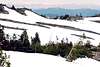
July to mid-October. Roads are closed and under snow most of the other time.
Camping

Camp at either trailhead at:
Cultus Creek Campground
or
Smokey Creek Campground
Also, nearby is Little Goose Campground
Mountain Conditions
Mt. Adams Ranger District(509) 395-3400
Gifford Pinchot National Forest