
|
|
Mountain/Rock |
|---|---|
|
|
45.78838°N / 123.10843°W |
|
|
Columbia |
|
|
Hiking |
|
|
Spring, Summer, Fall, Winter |
|
|
2265 ft / 690 m |
|
|
Overview
Long Mountain is the highest and most prominent point in Columbia County, Oregon. With that said, with an official summit elevation of 2265' Long Mountain has the lowest elevation of any Oregon county highpoint. In addition, of Oregon county greatest prominence points (CoGPPs), with only 1065' of clean prominence Long Mountain is the fifth-least prominent CoGPP in Oregon.The peak has little aesthetic value. Most people summiting the peak are probably those who are interested in county highpoints. Long Mountain is considered by many people to be one of the most boring county highpoints in Oregon, and perhaps with good reason. Fortunately, Long Mountain is also one of the most easily accessible county highpoints in Oregon, so not much time is required to visit the peak. Considering its relatively nearby location to major cities such as Hillsboro, Beaverton, St Helens, and Portland, day-trips and combination peakbagging trips are very possible.
Summit trips are non-technical, requiring at worst a steep bushwhack for several hundred feet of elevation gain to the summit ridge. Other people using the approach roads for Long Mountain are typically loggers and hunters. The upper slopes were heavily logged during the late 1990s and early 2000s, much of which has grown back, so its slopes and summit area has had a change of appearance over the years.
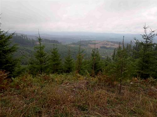 Western View During 2011
 Western View During 2003
Columbia County has had seven different peaks with fire lookout towers but curiously, despite being the highest and most prominent point not only in the county but also across a 14-mile radius, Long Mountain was not one of those peaks that ever had fire lookouts established. Maps do show a "Radio Towers" reference marked near the summit area. However, those towers were moved long ago. In reality, the Long Mountain summit area is (at least currently) just a logging road passing through a logging area.
 Summit Area During 2011
 Summit Area During 2003
Getting There
BASIC DRIVING DIRECTIONS:
STARTING FROM PORTLAND, OR:
1) Drive west along Highway 26.
2) After nearly 29 miles, turn right (north) onto NW Fisher Road. A road sign points to the small town of Buxton.
3) After 0.6 miles, veer right onto NW Bacona Road.
NOTE: The remainder of the driving directions will follow NW Bacona Road. The following markers are to assist drivers.
4) After 9.6 miles total along NW Bacona Road (which later becomes Hershey Road or Bacona CCC Road), park at the old road intersection on the leftside. There is a gated road. This intersection is marked as "1892" on topography maps. The gated road is the southern entrance to Corral Mainline.
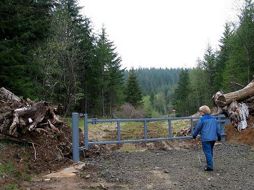 Gated Entrance To Corral Mainline
------------
HERE ARE DRIVING DIRECTIONS SHOWING MAJOR REFERENCE POINTS, TO ASSIST DRIVERS:
-> At the intersection of Highway 26 and NW Fisher Road, reset the odometer.
0.0 Miles - Turn right (north) onto NW Fisher Road, heading towards Buxton.
0.6 Miles - Veer right onto NW Bacona Road.
1.3 Miles - NW Bacona Road changes from paved to gravel.
3.7 Miles - Pass by intersection with Genzer Road (on leftside).
8.1 Miles - Pass by a "Road Closed 500 Feet Ahead" sign, and then veer left & uphill shortly thereafter to remain on NW Bacona Road.
 Important "Road Closed 500 Feet Ahead" Sign
9.3 Miles - Pass by a nice homestead (on rightside). This homestead is marked as "Bacona" on maps.
9.6 Miles - Point "2012" shown on maps. Veer right to remain on NW Bacona Road, shown on maps as either Hershey Road or Bacona CCC Road after Point "2012".
10.2 Miles - Point "1892" shown on maps, representing the intersection of Hershey Road and Corral Mainline. Park along entrance to Corral Mainline, on leftside of Hershey Road, but make certain not to block entrance gate.
 Entrance Gate For Corral Mainline
------------
HIKING DIRECTIONS:
1) From the entrance gate, head north along Corral Mainline towards Long Mountain (which can be seen in the background). Corral Mainline is a very overgrown, unused road. Corral Mainline follows a Natural Gas Pipeline, and numerous markers along the road show that.
 Walking Along Corral Mainline
2) After approximately 0.5 miles (~1950' elevation), leave the road and head steeply uphill (ENE) through thick forest and brush. There are no definitive paths; use common sense for best route. It is not uncommon for the ascent route and descent route to be different.
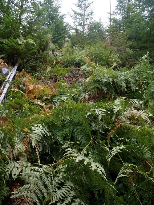 Example Of Bushwhack Section
3) If reaching the western end of the summit ridge, the summit road will be encountered at ~2200 elevation.
 Ascending The Summit Road...
4) Follow the summit road to the summit area. Touch each of the possible HP contenders surrounding the area.
------------
It is possible to follow roads all the way to the summit, but those possibilities include much longer routes. If bringing a mountain bike, the following options are recommended:
BIKE OPTION 1:
1) From the intersection of Hershey Road and Corral Mainline, being biking north along Corral Mainline.
2) Corral Mainline heads north towards Long Mountain, and then traverses around the west side of the peak.
3) After 1.5 miles, turn right (east) onto an unmarked road.
4) After 1.2 miles, turn right (south) onto another unmarked road, which is the summit road for Long Mountain.
5) After 1.2 miles, reach the summit area of Long Mountain.
BIKE OPTION 2:
1) From the intersection of Hershey Road and Corral Mainline, continue driving ENE along Hershey Road.
2) After 1.9 miles, veer left onto Jeppeson Road.
3) After 1.2 miles, turn left (west) onto an unpaved road. If road is open and drivable, continue. Otherwise, begin biking.
4) After 1.6 miles, turn left (south) at a "T" (or triangular) intersection.
5) After 0.1 miles, turn right (south) onto another unmarked road, which is the summit road for Long Mountain.
5) After 1.2 miles, reach the summit area of Long Mountain.
Red Tape
No special permits or fees are required to visit the mountain.Public access is granted year-round.
However, public visits are requested to occur during weekends and holidays, just in case of logging or quarry activities taking place during weekdays.
Snowslogger - Apr 11, 2021 7:27 pm - Hasn't voted
2021 Update - Gate Posted, Alternate FoundI went up to Long Mountain in mid-April 2021 and wanted to give a couple updates. I did not see the "Road Closed 500 feet ahead sign", but may have just missed it. The Corral Mainline road gate had signs on it indicated no entry, no tresspassing. I found another way that works though. I continued another 1.1 miles to an unmarked road that went left and uphill. I parked just after pulling off, but the road was in good shape and could be driven another 1/2 mile or so. This road ends up the east end of the Long Mountain ridge. From the road I went uphill through slash towards a small cluster of tall scraggly trees, then along a dirt road more or less along the crest, bypassing some minor hillocks, then up a small forested section to the summit area. Note that the radio towers shown on maps are no longer there. GPS is helpful.