
-
 6553 Hits
-
 77.48% Score
-
 8 Votes
|
|
Route |
|---|---|
|
|
46.96631°N / 10.90513°E |
|
|
Mountaineering |
|
|
A long day |
|
|
PD |
|
|
II |
|
|
Overview
Mainzer HöhenwegCountry:
Austria
State:
Tirol
Mountain range:
Ötztaler Alps (Geigenkamm)
Starting point:
 View from the Rheinland Pfalz Biwak (3252m)
Rüsselsheimerhütte (Chemnitzerhütte) 2328m
Finish point:
Braunschweigerhütte 2758m
Mountain peaks:
Wassertalkogel 3252m
Gschrappkogel 3197m
Wurmsitzkogel 3097m
Wildes Mannle 3063m
(and some other peaks without name, all just above 3000m)
Huts
Rüsselsheimerhütte (Chemnitzerhütte) 2328m
Rheinland Pfalz Biwak (emergency shelter on the summit of the Wassertalkogel 3252m)
Braunschweigerhütte 2758m
Distance:
9km
Time:
9-12 h (depends on the conditions)
Ascending:
+/- 1200m
Descending:
+/- 800m
Getting There
The Mainzer Höhenweg is a trail that lies between the Ötztal and Pitztal valleys. It is a part of the Geigenkamm that seperates both the valleys.The route is most commonly accessed from Plangeross (1612m) in the Pitztal valley. The Pitztal is accessable from Imst, a small village that lies next to the highway from Bregenz to Innsbruck. Plangeross lies almost at the end of the valley.
From Plangeross goes a relatively easy way up to the Rüsselsheimerhütte (2328m). Although it's only a 1.5-2h walk up, the path is steep, a bit overgrown and could be slippery in wet conditions. It is recommended to sleep at the hut, because the Mainzer Höhenweg on its own will take you a day and perhaps even more important the Steinbockgulasch served in the Rüsselsheimerhütte is very tasty.
Route Description
Mainzer HöhenwegRüsselsheimer Hütte, 2328m - Weissmaurachjoch, 2923m - Wassertalkogel, 3252m - Gschrappkogel, 3197m - Wurmsitzkogel, 3097m - Wildes Mannle, 3063m - Nördliches Pollesjöchl, 2937m - Südliches Pollesjöchl, 2961m - Pitztaler Jöchl, +/- 2990m - Braunschweigerhütte, 2759m.
Also known as: Hindenburgerweg. Partly with markings. High Alpine Ridge tour, with multiple peaks above 3000 meter. 9-12h. Emergency shelter at the Wassertalkogel, 3552m. (Rheinland Pfalz Biwak, 9 places, blankets, gas cooker, water available around the shelter). Emergency route down to Mandarfen in Pitztal. Difficult rockclimbing parts are secured with steel cabels. Because of the retreating glaciers, the Nördl. and Südl. Puitkogel glaciers can be difficult to cross, watch out for falling stones! Ensure that the weather is stable! In snowy conditions the route can be an almost total snow/glacier trail!
Starting at the Rüsselsheimerhütte(2328m), following the sign "Braunschweigerhütte", over moraines into the Weissmaurachkar (big Steinmann). In the lower part, 3/4h from the hut, lies the Weissmaurachsee. From the small lake, climbing next to the red markings with many steep turns up to the Weissmaurachjoch (2923m). (warning: in the last part the route can be difficult to spot, because of large amounts of snow, no trail is visible, only a steel cabel).
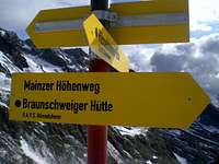 Sign on Weissmaurachjoch 2959m.
 Spot the signs
Weissmaurachjoch to the Rheinland Pfalz Biwak (Wassertalkogel)
From the Joch over the NE-ridge of the Puitkogel to the second markingpole. From the markingpole to the left(East) maintaining the same height until the Grubigkarleswand. Take the lowest point to pass the Grubigkarleswand (marking pole). Over a secured passage down, in the end over really loose stones on the Nördl. Puitkogel glacier. The glacier should be crossed at a height of +/- 3000m and this height should be kept. Through the Knappenloch (secured) to the Eastern rockridge of the Puitkogel and up to "Frühstücksplatz" (sign).
From this point through a steep passage 30m down to the Südl. Puitkogel glacier. Cross the glacier in big turns ascending +/- 80 meters. (watch out the lower parts could have crevasses). Then to the ridge that goes down to the Pollestal. Crossing this ridge in into the Schuttkar that lies NE of the Sonnenkogel (beginning is secured). From the Schuttkar over a 'Firn' field, east of the Sonnenkogel, in southern direction until the end of the eastern ridge of the Sonnenkogel. Around this ridge over another 'Firn' field up to lowest point in the ridge between the Sonnen- and Wassertalkogel. Further in SE direction over the ridge to the Rheinland Pfalz Biwakschachtel on the Wassertalkogel (3252m). (5.5h from the Rüsselsheimerhütte, emergency trail down to Mandarfen in the west!)
 Rheinland Pfalz Biwak 3252m.
 Climbing underneath the Wurmsitzkogel (3079m)
Rheinland Pfalz Biwak (Wassertalkogel) to the Braunschweigerhütte
From the Biwak, keep following the ridge in Southern direction to the Gschrappkogel. After the summit in many turns down to a deep carved rock passage, but then up to the rigde again. The trail keeps following the ridge further to the Wurmsitzkogel. The trail goes around with a steep passage continuing to the Wildes Mannle. From this point down to the Nördl. Pollesjöchl (Steinmann on the Jöchl), leaving the Pollesfernerkopf in the west continuing to the Südl. Pollesjöchl. Just before the Südl. Pollesjöchl there are two options. 1. Continuing over the Polleskogel to the Pitztaler Jöchl and down to the Braunschweigerhütte. or 2. Down to the Silbergrube and with the Franz Auer Steig up to the Braunschweigerhütte.
1. Over the Polleskogel and Pitztaler Jöchl
From the Nordl. Pollesjöchl the trail goes just beneath the Nördl. and Südl. Polleskogels. Just below the two summits the path goes down through a steep passage (secured) to the Südliche Pollesjöchl. From the Jöchl through rocky and steep terrain (secured) up to the Rettenbachferner. (to the left lies the restaurant of ski area Sölden). From the edge of the glacier it is not far to the Piztaler Jöchl. (4h from the Rheinland Pfalz Biwak). From the Piztaler Jöchl over a good path to the Braunschweigerhütte(2758m).
2. Down to the Silbergrube and up to the Braunschweigerhütte via the Franz Auer Steig (secured passage).
From the point between the Nordl. and Südl. Pollesjöchl down into the Silbergrube over a path. Here over a snowfield and with the help of steelcabels up to the Braunschweigerhütte (2758m) (Franz Auer Steig).
Credits to: "Ötztaler Alpen; Alpenvereinsführer, für Wanderer, Bergsteiger und Kletterer." by Walter Klier (Bergverlag Rother, 2006 München(GER))
Essential Gear
Basis Alpine Equipment (hard shell, insulation shell, gloves etc.)Rope & Climbingharness
Ice Axe
Crampons
Red Tape
Summer of 2009 (I do not know the current status)Pitztaler Jöchl was closed due to falling rocks from the Polleskogels. Normal tourist had to go over the Rettenbachjoch instead. Only strange thing is that there was no warning sign at the Mainzer Höhenweg! But I don't know the actual conditions (because we took the Franz Auer Steig)
Cartography & Literature
Maps:Alpenvereinskarte 30/5: Ötztaler Alpen/Geigenkamm (Wegmarkierung) 1:25.000 (edition 2006 (glaciers displayed as in 2004))
Books:
"Ötztaler Alpen; Alpenvereinsführer, für Wanderer, Bergsteiger und Kletterer." by Walter Klier (Bergverlag Rother, 2006 München(GER))