
|
|
Mountain/Rock |
|---|---|
|
|
46.94628°N / 10.91826°E |
|
|
Otztal Alps / Solden |
|
|
Hiking, Scrambling, Via Ferrata |
|
|
Spring, Summer, Fall |
|
|
9892 ft / 3015 m |
|
|
A SMALL Summit with BIG views...
 Descending to Pollesjoch with Schwarze Schneid
 Geigenkamm with Polles-Saddle and Wassertalkogel (3250m)
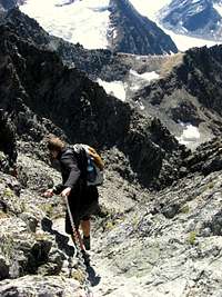 Via Ferrata (I) near Pollesjoch
 Nordlicher Polleskogel (3015m) with Verpeilspitze (3452m) and Wassertalkogel (3250m) in the background Nordlicher Polleskogel (3015m) with Verpeilspitze (3452m) and Wassertalkogel (3250m) in the background |
Nordlicher Polleskogel is a 3000meter peak situated on the Geigenkamm ridge in the Otztal Alps. It can best be described as a SMALL summit with BIG views.
The rocky summit is situated along the Mainzer Hohenweg. This route passes Nordlicher Polleskogel on the west flanks somewhat 150 vertical meters beneath the summit. Because this famous route does not lead up to the summit, it consequently makes Norlicher Polleskogel to a quiet, rugged and not very often climbed 3000 meter peak.
As the name already implies, Nordlicher Polleskogel is the small brother of the more famous and more frequently visited Südlicher Polleskogel. The advantage of Nordlicher Polleskogel is the difficulty of the climb.
For less experienced hikers/ climbers Nordlicher Polleskogel is a fine summit. The route includes a beautiful Via Ferrata (UIAA I) towards the Pollesjoch (2940m). The Ferrata is relatively easy and the only bottleneck (if you could already name it that) of the route. The route from the Pollesjoch to the summit can be described as an easy walk up. This final part leads over the Geigenkamm ridge with beautiful views in both the Pitztal (West) and Pollestal (East) Valleys.
Nordlicher Polleskogel can be nicely combined with climbing Südlicher Polleskogel. The main reason to do this is because of the views. From Südlicher Polleskogel the view North is somewhat blocked by Nordlicher Polleskogel. Ascending Nordlicher Polleskogel therefore offers some extra views. Especially the views into the Pollestal are fantastic. This rugged ‘side valley’ of the Otztal (main) valley is also recommended as descent route.
All in all, the Norlicher Polleskogel is a 3000 meter peak with an easier ascent route (UIAA I) compared with Sudlicher Polleskogel (summit block: UIAA I-II), therefore accessible for any experienced hiker and also a great goal for the 3000er-gatherer.
 View form the Polles-Saddle towards Pollesferner and Stubaier Alps View form the Polles-Saddle towards Pollesferner and Stubaier Alps |
Routes
 View towards the Glacier Street
 Sudlicher Polleskogel as seen from Nordlicher Polleskogel
 Mainzer hohenweg @ Pollesjoch (2940m)
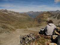 Summit view into the Rugged Pollestal
 Overview Map
 Nordlicher Polleskogel Summit Block
The Normal Route starts at the end of the Glacier street. It can be seen on the map below marked in RED. This road-end contains a large parking place where parking is free of charge.
Leave the parking place in a North-West direction. (This is the only way that goes up in elevation and is marked with red-white-red stripes, it simply cannot be missed). This first part is an easy hike-up (graded T3). Following this trail eventually leads to a split-up. Going left will lead you to the Pitztaler Joch and to the Braunschweiger Hut.
Please note:
This road is CLOSED because of increasing danger of falling rocks. We saw some people ignoring the closure and they got in all kinds of trouble, with rockslides coming nearer and nearer before they eventually turned back. So don't go here!!
Back to the split-up: Take a right here (follow the signs ‘’Pollesjochl’’). Shortly after the beautiful Via Ferrata starts. Graded I, it is technically easy but nonetheless very beautiful. The Via Ferrata goes up until you reach Pollesjoch at 2940m. From here you get your first sight into the Pitztal. At Pollesjoch you are now officially at the Mainzer Höhenweg. Follow the road towards the north (some secured lines), at your right hand you will see the Polleskogel. In less then 5 minutes you will arrive on the ridge (Geigenkamm) and have spectacular views into the Pitztal (west) and Pollestal (east.)
Follow the ridge to the North. The marked trail (Mainzer Hohenweg) goes to the left and passes the West Flanks of Nordlicher Polleskogel. Simply ignore this path and keep heading up over the ridge in a Northern direction. After some 10 minutes you arrived at the summit of Nordlicher Polleskogel.
Ascent Time: +- 1,5 Hours
Descent is back down the same way over the ridge. When you reach the saddle between Nordlicher and Sudlicher Polleskogel you can descent down into Pollestal (see MAP below marked in BLUE, 3-4 hours) You can also descent the same way back to the Glacier Street. (1-1,5 Hours)
 Route Overview: Ascent in RED; Descent into Pollestal in BLUE
Alternative:
A great alternative is to do the Mainzer Hohenweg from the Russelheimer Hut to the Braunschweiger Hut.(or the other way around). This route follows the Geigenkamm ridge and therefore includes beautiful views into both the Pitztal and Otztal. It also leads over the following 3000meter peaks:
Südlicher Polleskogel (3035m), Nördlicher Polleskogel (3015m), Wurmsitskogel (3078m), Gschrappkogel (3191m) and Wassertalkogel (3242m).
For more information please see the Mainzer Hohenweg Route Page
How to get there
 Seekogel (3353m) and Watzespitze (3534m) as seen from the summit of Nordlicher Polleskogel (3015m)
Route Description:
From the West:
Vorarlberg - Tirol via Arlberg Pass or trough Arlberg Tunnel (S 16 Federal Road) - direction Landeck - change to A 12 Autobahn - exit: Ötztal - B 186 Federal Road (35 km) to Sölden
From the North:- Bad Tölz - Achen Pass - B 181 Federal Road - Jenbach - A 12 Autobahn - Innsbruck - exit: Ötztal - B 186 Federal Road (35 km) to Sölden - Pfronten - Reutte - Fernpass - Imst - A 12 Autobahn - exit: Ötztal or B 171 Federal Road to Ötztal (no Vignette toll-sticker required!) - B 186 Federal Road (35 km) to Sölden - Garmisch Partenkirchen - Mittenwald - Scharnitz - Seefeld - Telfs - A 12 Autobahn - exit: Ötztal or B 171 Federal Road to Ötztal (no Vignette toll-sticker required!) - B 186 Federal Road (35 km) to Sölden
From the East:
Munich or Salzburg - A 93 Autobahn to Kufstein - A 12 Autobahn direction Innsbruck - Ötztal - B 186 Federal Road (35 km) to Sölden
From the South:
Merano/South Tirol - via Timmelsjoch Pass to Sölden. High Alpine road leading up to 2.500 m above sea level. The Pass is open only from the beginning of June to the middle/end of October. Toll road!
You can find a RoutePlanner here!
Soldener Glacier Road
See MAP Above: The Glacier road starts just south of the village of Solden. It is the first exit after you leave solden in a southern direction. The signs are very clear!
You have to pay an entrance fee of about 20 euro's for this road.
More info: Glacier Road
Panorama

Annotated 360° panorama from Nördliches Pollesjoch.
Nordlicher Polleskogel in the pano = Sudlicher Polleskogel (3035m)
Another name for Pollesfernerkopf (3015m,in pano) is Nordlicher Polleskogel
Weather & Glacier Road
 Flowers along the Route...
 Solden as seen from the lowe part of the Glacier Street
Weather:
Weather Forecast Solden
Glacier road info:
Glacier Road
Maps & Books
 Leichte 3000er
Book:
Leichte 3000er mit Weg: Die 99 Schonste Touren (in German)
2004, Bruckmann, ISBN 3-7654-4188-0, 144 pages, ca. 120 Photos
Map:
--> AV-Karte, Ötztaler Alpen, Blatt 30/6 (Wildspitze).
Camping & Huts
 From left to right: Rofelewand (3370m), Wurmsitzkogel (3078m), Gschrappkogel (3191m), Wassertalkogel (3250m) and in front: Nordlicher Polleskogel (3015m)
There are some beautiful campsites in the main Otztaler valley:
Camping Otztal Langenfeld
NaturCamping Otztal
Huts:
Braunschweiger Hut
Russelheimer Hut
 Braunschweiger Hut Braunschweiger Hut |  Russelheimer Hutte Russelheimer Hutte |
|---|