
-
 11515 Hits
-
 81.18% Score
-
 13 Votes
|
|
Mountain/Rock |
|---|---|
|
|
51.59454°N / 116.60632°W |
|
|
Mountaineering |
|
|
Spring, Summer, Fall, Winter |
|
|
10371 ft / 3161 m |
|
|
Overview

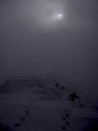
Mont des Poilus is located in Yoho National Park, British Columbia, near the Continental Divide, just south of the Wapta Icefield. The surrounding alpine environs are extensively covered in glacial fields, with many high elevation summits nearby. This rugged and pointed peak reaches an elevation of 3161 metres (10,371 ft.). To south of Mont des Poilus, Glacier des Poilus falls into the scenic Waterfall Valley.
Once referred to as Hidden Peak, and once named Mount Habel (after Jean Habel, first European to explore the Yoho Valley in 1890’s), the current name was applied in 1917 to honour the “Poilu”, the lowest ranking soldiers of the French Army who courageous battled the invading Germany armies during the First World War. First ascent in August 1901 by J. Outram, E. Whymper, C. Kaufmann, C. Klucker and J. Pollinger via Glacier des Poilus and South Ridge.
Getting There
Typically ascents of Mont des Poilus occur during the height of summer in August, with most parties approaching from Waterfall Valley in Yoho National Park. Yoho is located on the Trans Canada Highway, approximately 210 kilometres west from Calgary, 80 kilometres west of Banff and about 55 km east of Golden, British Columbia.The Takakkaw Falls road, typically closed from September to June, provides vehicle access to the upper Yoho River Valley. Approach from the Banff-Jasper highway is possible and fairly common in the winter or spring, but requires extensive glacier travel over significant distances. An ascent of Mont des Poilus is excellent addition to the Bow to Yoho Traverse of the Wapta Icefield.
Red Tape / Camping and Bivouacs
A permit or fee is not required to climb in Yoho National Park. A voluntary safety registration system is available for climbers in the rocky mountain national parks. It is necessary to register in person at the park information centres or warden offices during business hours. On completion of the excursion, the party must notify the park by telephone or by returning the registration form.Yoho National Park is one of the most regulated backcountry areas within Canada. The Yoho River Valley is not as regulated as other areas in Yoho and generally follows standard National Park backcountry requirements. Any overnight stay, be it in a designated backcountry campground, in an Alpine Club of Canada hut, a hanging bivy or a cozy camp within a crevasse, requires a wilderness pass.
Yoho backcountry camping link
Yoho winter backcountry link
When to Climb
Typical Canadian Rockies situation with July and August providing the best conditions for high elevation climbing. Ski mountaineering ascents generally have the best conditions in the spring, March through May. An ascent at anytime of the year is subject to avalanche danger.
Approach
The Takakkaw Falls road, typically closed from September to June, provides vehicle access to the upper Yoho River Valley. Approach from the Banff-Jasper highway is possible and fairly common in the winter or spring, but requires extensive glacier travel over significant distances and multiple accesses are possible, only the summer approach is described.
From the northern terminus of the Yoho River Valley/Takakkaw Falls Road park in the large parking lot. Trailhead access is at the northern end of the parking area and is well signed. Hike to Twin Falls about 8 km and about 300 m of elevation gain. From the designated trail above Twin Falls, head north into Waterfall Valley.
Camp along the southern toe of Glacier des Poilus, South West of Yoho Peak. Access to Mont des Poilus is from the main glacier.
Route Description
Only one route has been documented on Mont des Poilus. First ascent in August 1901 by J. Outram, E. Whymper, C. Kaufmann, C. Klucker and J. Pollinger.- South Ridge, Alpine II
Moderate snow/ice glacier mountaineering route. From main Glacier des Poilus, head up glacier on southern slopes of des Poilus. In summer conditions many large crevasses are exposed, and hidden, on the route, attention is required. Glacial slopes steepen nearing South Ridge. Depending on conditions, a bergschrund may be visible.
Final 40 metres to ridge line steep, about 40 degrees, typically hard packed snow. Final summit ridge of about 150 horizontal metres is a hike on rock or snow. Descent the same route.

|
 |
 |
|---|