
-
 9248 Hits
-
 78.27% Score
-
 9 Votes
|
|
Mountain/Rock |
|---|---|
|
|
52.51561°N / 117.37662°W |
|
|
Mountaineering |
|
|
Summer |
|
|
10341 ft / 3152 m |
|
|
Overview
Coronet Mountain is an exciting mountain with several steep ridges, formidable faces and an elegant north glacier in southern Jasper National Park. Coronet Mountain has a reasonable height (3152m, 10,342 ft.) and is in a fairly accessible remote area, but it sees little attention. This beautiful peak sits just off the edge of the Le Grand Brazeau, a large high elevation plateau covered in thick glacier ice, one of the largest icefields east of Highway 93 in the Canadian Rockies’ National Parks. The Le Grand Brazeau contains five significant summits, Mt. Brazeau (3500m), Mt. Warren (3350m), Mt. Henry Macleod (3315m), Valad Peak (3250m) and Monkhead (3250m). Mt. Brazeau and Mt. Warren see more and more climbers, but Coronet Mountain is rarely climbed, and likely has fewer than a dozen summits. First ascent in August 1930 by R. Baring, G. Gambs, K. Gardiner, S. Hendricks, W. MacLaren, P. Prescott, and H. Sampson from Coronet Creek, up main Coronet Glacier then traversed to, and climbed the South Ridge.Coronet Mountain is in the Queen Elizabeth Range, fourth highest in the range after Mt. Unwin (3268m), Mt. Charlton (3217m) and Mt. Mary Vaux (3201m). This range is generally west of Maligne Lake and north and east of Maligne River. The range was named in 1953 to commemorate the coronation of Queen Elizabeth II of the United Kingdom. Coronet Mountain was named by Howard Palmer in 1923. The mountain had a snow formation near the summit which resembled the shape of a crown.
Getting There
 Area Map
Jasper National Park joins Banff National Park to the south via the Icefields Parkway. This parkway offers scenic driving, and more importantly, access to some of the best alpine and waterfall ice climbing in the world. The parking areas for all routes is at the Poboktan Creek trailhead, approximately 165 km north of the Trans Canada Highway or 70 km south the town of Jasper.
Red Tape / Camping and Bivouacs
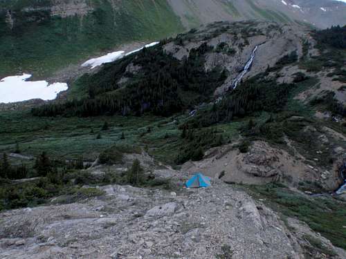 Restful bivy
All national parks in Canada require an entrance fee. No permit or fee is required to climb in Jasper National Park. A voluntary safety registration system is available for climbers in the rocky mountain national parks. It is necessary to register in person at the park information centres or warden offices during business hours. On completion of the excursion, the party must notify the park by telephone or by returning the registration form.
Up to date information about climbing and mountaineering in Jasper National Park available at: Jasper National Park | Climbing and Mountaineering
Climbers are permitted to bivouac on long routes or otherwise where necessary to safely complete a climb. Some restrictions apply; mostly prohibiting the most popular peaks. A backcountry use permit is required for any overnight stay, contact any Jasper National Park visitor centre, where you may obtain the permit. Great bivy locations for accessing the west slopes and north-west ridge of Coronet Mountain are abundant with great views and plenty of water, our bivy was located at NTS UTM grid reference 726185 (52.51017, -117.402607).
Approach
A bit of an odd parking area and access to the trail. Back in 2005 the bridge that crosses Poboktan Creek had the railings torn off by raging flood waters. When I climbed Mt. Brazeau in 2007 you could still use the bridge deck for crossing the creek. Now the entire bridge structure has been removed and will not be replaced. Park in the large parking lot just south of the creek and highway crossing, head back to the highway, hike north across the highway bridge and then to the Sunwapta Warden Station. Behind the station and near the horse coral there is a sign for the trail.

|

|

|
| Poboktan Creek parking area | Typical view on trail | The odd trail view point |
Follow the Poboktan Creek trail for about 6.5km to the obvious intersection meeting the turnoff for Poligne Creek. There is good signage for this turnoff. Follow the trail north-west along Poligne Creek for about 2km, near NTS UTM grid reference 743148 (52.483367, -117.378188) exit the trail and head due north into the drainage than originates from between Replica Peak and Coronet Mountain.

|

|

|
| Poligne Creek turnoff | Head to avalanche camp | First bridge on Poligne Creek |
Head up stream towards Coronet as far as you wish, we are approaching in the dark and decided not to proceed all the way to our original destination, the col north of Coronet, and instead bivyed at 726185 (52.51017, -117.402607). The west slopes of Coronet Mountain provide mostly treadmill and loose scree all the way to the north-west ridge crest. Luckily we found some large, well frozen snow patches nearing the top to lessen the slog. Large sections of steep slabs are present and would be difficult to ascend, stick to the scree and large boulders to reach the ridge. From the valley aim for the lowest of three highpoints along the ridge; the most southern highpoint (difficult to see) is the main summit, the middle point is the lower north summit and the other is a good target.

|

|

|
| View to south end of Coronet | Summit in centre of ridge | View up West slopes to NW ridge |
When to Climb
Typical Canadian Rockies situation with July and August usually providing the best conditions for high elevation climbing. Often September and October have stable and dry weather, but conditions can change dramatically. Fall climbing does provide colder temperatures for snow climbing, but with less snow for climbing and bridging of crevasses. No record of a winter of Coronet Mountain could be found; the North-West Ridge is climbable in winter conditions, under stable snow conditions.Route Descriptions
The only published route information is in the “The Rocky Mountains of Canada South”, Boles, G.W., Kruszyna R. & Putnam W.L. (1979) guidebook. Three routes are documented on Coronet Mountain. Would recommend the North-West Ridge to West Slopes for any descent.- South Ridge, Alpine II
First ascent of the mountain. In August 1930 by R. Baring, G. Gambs, K. Gardiner, S. Hendricks, W. MacLaren, P. Prescott, and H. Sampson. From camp in upper Coronet Creek, up main Coronet Glacier then traversed to, and climbed South Ridge. Final ridge on steep, but good quality rock.
- North-West Ridge, Alpine II
Second ascent of the peak, August 1930 by E. Clarke, W. Cleveland, M. Davis, J. Forkes, B. Jefferson, F. McCulloch, M. MacLeod and D. Sharpe. From camp in upper Coronet Creek, then to the col on north end of Coronet Mountain. Up loose scree slopes on the west slopes to the ridge crest. Up north-west ridge to fore-summit, then up snow/glacier ice slopes to main summit.

|

|
|
| On NW ridge, view to first bump | Nearing first, fore summit | Near top of ridge, view to summit |
- North Glacier, North Face, Alpine III
July 1962 by P. Hodgkins, G. Neave, L. Norgren, W. Sharp, G. stefanick, G. Strickholm, W. Pfisterer. From col north of Coronet Mountain gain glacier and travel up steepening snow/ice slopes to main summit. Recent glacial recession makes this glacier extremely difficult to access.

|

|

|
| North Glacier left of NW ridge | Col north of Coronet | Glacier difficult to access |