-
 7509 Hits
-
 83.69% Score
-
 17 Votes
|
|
Mountain/Rock |
|---|---|
|
|
52.26913°N / 117.39332°W |
|
|
Mountaineering |
|
|
Spring, Fall |
|
|
10925 ft / 3330 m |
|
|
Overview
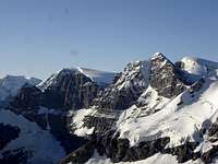
Mount Cromwell stands just north of the Columbia Icefield and is a beautiful and challenging peak, but sometimes overshadowed by its impressive neighbours. Standing at 3330m (10,926ft.) this mighty peak provides many sheers walls along its impressive blocky summit and provides several difficult mixed alpines routes. The summit is approximately the 14th highest in Jasper National Park.Recently named in 1972 for Oliver Eaton Cromwell, an American who began climbing in the Canadian Rockies in 1928 and made many first ascents; including the first ascent of Mount Cromwell. First ascent made in 1936 led by guide Edward Feuz Jr. along with Oliver Cromwell and his son Oliver junior, F. North and Monroe Thorington. Their ascent was by the East Face and South Ridge, utilizing the lower East Face glacier to gain the base of the South Ridge (Mt. Cromwell/Stutfield Peak col), then easy rock to the summit. This glacier has deteriorated substantially since 1936.
 North end of Columbia Icefield
Getting There
Mount Cromwell is approached from the Icefield Parkway (Banff-Jasper Highway (Highway 93)). Depending on the chosen route, there are three approaches, with two sharing the same parking area.From Calgary drive west 165 km on the Trans-Canada Highway to Lake Louise in Banff National Park. From Canmore drive west 81 km to Lake Louise. From Lake Louise drive west 3 km on the Trans-Canada Highway to the Banff/Jasper Highway 93, drive north 125 km to “Columbia Icefield Discovery Centre” and the toe of the Athabasca Glacier.
If heading to the base of the North Face or East Face, park as for the Woolley Creek approach. Drive an additional 12.5 km north of the “Columbia Icefield Discovery Centre” to a pull out on the east (right) side of the highway (approximately 52.300973, -117.330059) (same parking area and approach beginning as Diadem Peak, Mt. Woolley and Mt. Alberta).
 Area map
Red Tape / Camping and Bivouacs
All national parks in Canada require an entrance fee. No permit or fee is required to climb in Jasper National Park. A voluntary safety registration system is available for climbers in the Rocky Mountain National parks. It is necessary to register in person at the park information centres or warden offices during business hours. On completion of the excursion, the party must notify the park by telephone or by returning the registration form.Up to date information about climbing and mountaineering in the Rocky Mountain National parks available at: Rocky Mountain National parks | Climbing and Mountaineering
During the ski season, up to date avalanche bulletins for the Rocky Mountain National parks are available at:
Avalanche Bulletin – Jasper National Park
Avalanche Bulletin - Banff, Yoho and Kootenay National Parks
Climbers are permitted to bivouac on long routes or otherwise where necessary to safely complete a climb. Some restrictions apply; mostly prohibiting the most popular peaks. A backcountry use permit is required for any overnight stay, contact any Jasper National Park visitor centre, where you may obtain the permit.
Most parties will bivy or camp near the base of the chosen route and ascend the mountain the following day.
Approach
Woolley Creek/Woolley Shoulder Approaches
Park in the pull out parking area, 12.5 km north of the “Columbia Icefield Discovery Centre”, on the east side of the highway (approximately 52.300973, -117.330059) (same parking area and approach beginning as Diadem Peak, Mt. Woolley and Mt. Alberta). Head west to Woolley Creek, an obvious steep wall creek opening across the gravel flats of the Sunwapta River. Must ford the braided Sunwapta River enroute to the creek; depending of time of the year and day, the river can be just over ankle deep to about waist deep, aim to cross early in the day.
A good trail exists in the main valley of Woolley Creek, but the trial can disappear in some sections of boulders, overall easy to follow.
North Face Approach
If heading to the North Face routes, you travel about 3 km up the Woolley Creek trail, turn south and bivy near the base on the North Face, usually an additional 1km to reach the bivy area.
East Face/South Ridge Approach
The South Ridge can be accessed from the northern edge of the Columbia Icefield and makes a good addition to an ascent of the Stutfield Peak and “East Stutfield”. The lower glacier on the East Face has deteriorated considerably since the first ascent and is not climbed very frequently, if at all. Ascending this face maybe possible, but this approach to the South Ridge is no longer recommended.
If heading to the lower East Face, continue up Woolley Creek to Woolley Shoulder, head south into upper Habel Creek and bivy near the glacier.
Athabasca Glacier Approach
The most straightforward, but likely not used very often, approach to Mount Cromwell is from the Athabasca Glacier. It is a long approach over a vast icefield and requires good visibility and experience travelling on heavily crevassed terrain. From the toe of the glacier parking area, or if the short access road is closed (not ploughed in the winter), from the highway side parking lot, ski towards the toe of the Athabasca Glacier.
At the toe of the Athabasca Glacier head up the right side (northern edge) towards a ramp that provides access to the Columbia Icefield, the ramp base is about 5 km from the toe.
 |
 |
 |
| Toe of Athabasca Glacier |
Base of ramp | Near top of ramp to Columbia Icefield |
Once on the Columbia Icefield the southern edge of Snow Dome must be circumnavigated; generally stay south of the big and obvious crevasses on the south east slopes of Snow Dome, heading west, then angling north, north-west. The Columbia Icefield is not flat, and a serious of glacier hills and valleys are traversed as you head north to your objective.
 |
 |
 |
| Skirting Snow Down | Heading north to Twins | Long ski to base camp |
Generally to ascend Mount Cromwell (or any of the The Twins (North Twin, South Twin, Twins Tower or “West Twin”)) the base camp should established as close as possible to the The Twins/Stutfield Peak Col, about 52.223, -117.408.
 |
 |
 |
| Nearing the bivy site | Camp view to Stutfield Peaks | Camp view to Twins |
To access the South Ridge of Mount Cromwell you must ascend to the summit of Stutfield Peak. From The Twins/Stutfield Peak Col, about 52.223, -117.408 head north to the broad and low angled South Ridge of Stutfield Peak, a steeper section presents itself just below the flattish summit ridge, this slope does have avalanche risk, especially late in the spring, assess conditions before ascending. Once above this steep section, it is a simple ski/walk to the summit of Stutfield Peak.
 |
 |
 |
| Approaching Stutfield | View to Mt. Alberta | Nearing South Ridge |
From the summit of Stutfield Peak, ski/walk north and descend to the Stutfield Peak/Stutfield East Col. From the col, a traverse of the lower North West slopes of Stutfield East is required, this side traverse is fairly steep and does have avalanche potential. Continue to ski/walk to the base of the South Ridge of Mount Cromwell.
 |
 |
 |
| Stutfield summit | South Ridge of Cromwell | View to Stutfield saddle |