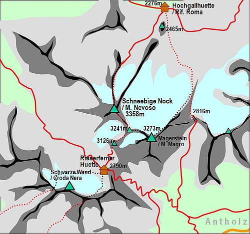
- July 2007 – Attached two route descriptions (From Rifugio Roma/Hochgall-huette) and traversing from Schneebige Nock / Monte Nevoso.
- 28 September 2005 – Start up of the page. Thanks to Vid Pogachnik for comments and suggestion before posting the page.
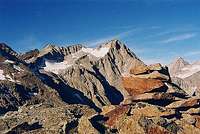
Overview
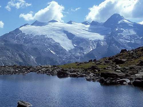
View of the Vedrette di Ries/Rieserferner glacier. By Mathias Zhering
Monte Magro / Magerstein (3273 meters) is one of the summits of the Rieserferner group . It is not the most important, but both in summer and in winter-spring time many climbers and/or ski mountaineers decide to ascend it.
The mountain is located between the Valle di Anterselva / Antholzer Tal and the Valle di Riva / Rein Tal, so that there are different routes from both the valleys. From Antolz /Antreselva the South side appears as a very imposing mountain, with steep and majestic rocky walls. On the other hand, the North side is occupied by the wide Vedretta di Ries / Rieserferner glacier (Magersteinferner). The ascent is not difficult from any starting point, but a complete alpine equipment is however recommended even in summer.
A well trained climber could try interesting combinations with nearby summits, linking the ascent to Monte Magro / Magerstein with the ascent to Schneebige Nock / Monte Nevoso (3358 m). In this case you can ascend by the N ridge of Schneebige Nock / Monte Nevoso and descend by the E ridge, continuing towards Magerstein / Monte Magro (read more on the Schneebige Nock / Monte Nevoso page. It is possible also vice versa.
The central posiition on the upper limit of the Rieseferner glacier assures an interesting view on all the other summits of the Rieserferner Group, from Hochgall/Collalto (3426 m) and Wildgall/Collaspro (3273 m) at North-East, to Fernerkofel/Pizzo delle Vedrette (3241 m) and Schneebige Nock / Monte Nevoso, at North-West. At the same time, with good weather conditions you can easily recognize many of Dolomites.
The presence of ski mountaineers is constantly increasing because of very beautiful sky-routes, available in this area. For these the base is the Hochgallhuette / Rifugio Roma.
The mouth of the glacier actually disappeared
The first ascent by Kirchler, Reuschle and Seyerlein was done in 10th of July, 1878 ascending from South the Antolzer saddle (Antolzer Scharte / Forcella d'Anterselva) and then climbing the E-NE ridge
Tristennoeckl /Monte Covoni
About 100 meters above the Rifugio Roma / Hochgall Huette there is a characteristic rocky "Gendarme" called Tristennoeckl /Monte Covoni (about 2400 meters). It is an easy ascent, not more than 30-40 minutes far from the hut, along a trail supported, for few meters, by a metallic rope. This ascent can be done with pleasent in the afternoon, the day before you intend to ascend the Monte Magro, as training for the next day. A very beautiful view to the Rieserferner Group and to the summits surrounding the Valle di Riva / Reintal (Dreieckspitze / Triangolo di Riva, Durreck, Mosstock, Lenkstein / Sassolungo) is the present for which of us arrives on its summit.
Getting There
For general orientation see the broader Hohe Tauern page.
Rieserferner mountains can be reached:
1. From Austrian side, from Isel valley. In Huben turn West and drive through Defreggental.
2. From Italian side. In Rienz valley (Val Pusteria / Pustertal) turn North and drive either into Valle Aurina / Ahrntal and further into Valle di Riva / Raintal or in Valle di Anterselva / Antholzertal.
Monte Magro / Magerstein is usually ascended from the village of Rein/Riva di Tures, 1596 m. The most common trailhead starts in Bachertal/Val del Rio, on the parking place at Saege, 1580m. From there a good marked path goes up to Rifugio Roma/Hochgallhuette. In case of starting from Rifugio Forcella Valfredda/Rieserferner huette the traihead is more SW of the village, where on the altitude of some 1520 m the marked path crosses the Reinbach and enters the Gelttal.
Another option, directly to the summit, is from Antholz valley/Valle di Anterselva, starting on the altitude of some 1600 m and following the marked path towards the saddle Antolzer Scharte/Forcella d'Anterselva (2861 m) and then to the summit.
Route overview
Two main routes are possible starting from Valle di Riva / Raintal.
1) From Rifugio Roma/Hochgall-huette (2276 m)
It is an ascent of about 1000 meters, on well marked trail (there are clear indication on the stones), moraine and easy glacier, following just below the rocky ridge corresponding to the upper limit of the Westlicher Rieserferner / Vedretta di Ries Occidentale. About 4:00 hours for the ascent and 2:30 hours for the descent by the same route. I climbed this route in different glacier condition. The last years, because of the glacier’s withdrawal, the attack of the glacier is higher and can be convenient ascending at first directly the NE ridge and then continuing over the glacier.
2) From Rifugio Forcella Valfredda / Rieserferner-huette (2791 m)
The ascent foresees at first to reach by a not difficult trail the Fernerkoepfl / Pizzo di Vedrette (3241 m). Then continuing towards East along the West ridge of Frauenkoepfl (3251 m) (or also, depending on the glacier condition, turning around the Frauenkoepfl summit over the Magersteinferner), you arrive at the base of the Monte Magro / Magerstein rocky summit, to be ascended easily. About 2:30-3:00 hours for the ascent and 2:00-2:30 hours descending to Rifugio Roma /Hochgall huette, or 1:30-1:50 descending to the starting point.
Even if not much frequented, an alternative is also by a very long, lonely and tiring ascent (about 1700 meters). The route starts from above Anterselva di Mezzo /Antolz Mittertal, at 1600 about meters, through a very steep trail not always evident, up to the saddle Antolzer Scharte / Forcella d'Anterselva(2861 m). Then, turning left towards North-West, following the route coming from the Rifugio Roma /Hochgall huette. About 4:15-4:45 hours up to saddle and about 1:30 hour to the summit. The descent is possible to Rifugio Valfredda / Reiserferner Huette or to Rifugio Roma / Hochgall Huette.
Accomodations & Huts
Many B&B (so called Garnì) are present in the valleys. Information on the accomodations (types, prices, booking, etc.) are available on this web page of the Ahrntal / Valle Aurina's touristic office.
The main village is Rein in Taufers / Riva di Tures (1596 m) in Valle di Riva / Raintal. Here there are the trailheads to the two huts for approaching the Monte Magro / Magerstein.
Rifugio Forcella Valfredda / Rieserferner-huette (2791 m) (also called Gaensebichljoch Huette), 2791m. Opened from end of June till start of October. 60 beds. Tel.: hut: 0474 49 21 25, private: 0474 49 22 28. The hut stands on the saddle between Schneebige Nock / Monte Nevoso and Schwarze Wand. It can be reached by marked routes from Valle di Riva / Raintal and from Antholzertal / Valle d'Anterselva. The hut is also the starting point for ascents on Schneebige Nock and Schwarze Wand.
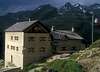
Rifugio Roma/ Hochgall Huette (2276 m) also Kasseler Huette (old name), or Rifugio Roma (because the property and the authority responsible of inspection is CAI of Rome), 2276m. Opened start of March till Mid May and Mid June to Mid October. 70 beds. Tel.: hut: 0474 67 25 50, private: 0474 67 25 21. From Rein in taufers / Riva di Tures a short side valley goes towards SE, taking all water from glaciers of hihgest Rieserferner summits. On a beautiful terrace above the valley a hut stands, offering the best starting point for tours on many summits such as Hochgall / Collalto, Wildgall / Collaspro, Schneebige Nock / Monte Nevoso and Lenkstein / Sassolungo. Around the valley also a nice panoramic marked trai goes (so called Arthur Hartdegen Weg).
In Antholz / Anterselva valley there is a camping place just below the trailhead for Rieserfernerhuette.
When To Climb
From mid June to end of September, there are the best climbing conditions. Ski mountainering is possible from February to April.
It is recommended to use high mountain equipment, ice-axe and crampons, depending on the glacier condition. In advanced summer, following the route on the rocky ridge and partially on the glacier, crampons can be usless.
From South
Ski route
Mountain Conditions
You can get a view of the site from this Webcam of the village Rein in taufers / Riva di Tures.
Children refers to the set of objects that logically fall under a given object. For example, the
Aconcagua mountain page is a child of the 'Aconcagua Group' and the 'Seven Summits.' The
Aconcagua mountain itself has many routes, photos, and trip reports as children.
Parents refers to a larger category under which an object falls. For example, theAconcagua mountain page has the 'Aconcagua Group' and the 'Seven Summits' asparents and is a parent itself to many routes, photos, and Trip Reports.