
-
 4270 Hits
-
 79.78% Score
-
 11 Votes
|
|
Mountain/Rock |
|---|---|
|
|
46.10100°N / 8.80621°E |
|
|
Hiking |
|
|
Spring, Summer, Fall |
|
|
5230 ft / 1594 m |
|
|
Overview
 Sasso Corbaro and Covreto Sasso Corbaro and Covreto |
Based on a PM discussion I had with Vid the other day I decided to bring up this page about three summits in the Lago Maggiore Area , all located close to each other in a radius of 500m and separated by rather insignificant saddles: Monte Paglione (1554m), Covreto (1594m) and Sasso Corbaro (1548m). Last year in June I stood on the former two and only the massive clouds which started rolling in prevented me from visiting the third of the triplet.
The region on the eastern shore of Lago Maggiore, called Gambarogno, is famous for its hikes with beautiful vista. The crown jewell is Monte Tamaro closely followed by Monte Gambarogno, both of which offer stunning views of the lake together with far reaching vista of the western and central Alps. South-west of these two summits, separated from Monte Gambarogno by Passo Sant'Anna you can find the ridge which contains the three summits, which are positioned in triangle with unequal lengths.
 |  |  |
Monte Paglione is the best known of these summits, even better known than Monte Gambarogno on the other side of the pass. In literature and on maps the whole ridge, including Gambarogno, is called Monte Paglione. However, it is neither the highest summit of the ridge nor its most impressive. You will find a broad, plateau-like, top from which you'll have to descend a few hundred metres in order to be able to catch a glimpse of the lake. On the other hand, Monte Paglione is the spot where the Swiss - Italian border (often confusing in these parts) bends in a sharp turn south-westward, giving the summit the importance of a geodetical marker.
 |  |  |
The border heads for the saddle, which separates the other two summits, where it turns westward again, thus bypassing Covreto, the highest summit of the three. Thus Covreto fully lies on Swiss ground, if only barely (about 100m). It is a cone-shaped hill, more distinct than Monte Paglione but not much more impressive. Covreto has a summit cross, which is located a bit south-west of the real summit in order to be seen from the lakeshore. From there you have the best views of the three mountains, including the southern parts of Lago Maggiore as well as the North Italian plains beyond.
Set a bit aside to the south, annd thus fully on Italian ground, there is Sasso Corbaro. The lowest of the three summits is a ridge mountain, similar to Monte Gambarogno in its north. Here you have wonderful views of Valle Veddasca and the ridge between Monte Tamaro and Monte Lema across which the wonderful ridge traverse La Traversata runs.
 |  |  |
All three mountains are rather rarely visited as La Traversata together with Monte Gambarogno don't leave much room for other destinations. Still, you can easily climb all three together with Gambarogno starting either from Indemini in Valle Veddasca in the east or from Monti di Gerra in the west. In either case you'll have to pass Passo Sant'Anna, an old but important pass which connects the lake front with the mountain villages in Valle Veddasca. In late spring all three summits will be covered in alpenroses, a wonderful sight.
Even further to the south-west, separated from the trio by the saddle La Forcola is the fourth and final mountain of the ridge, Monte Cadrigna (1300m). The humblest in size it stil is a magnificient viewpoint with its unobstructed views of the southern Lago Maggiore.
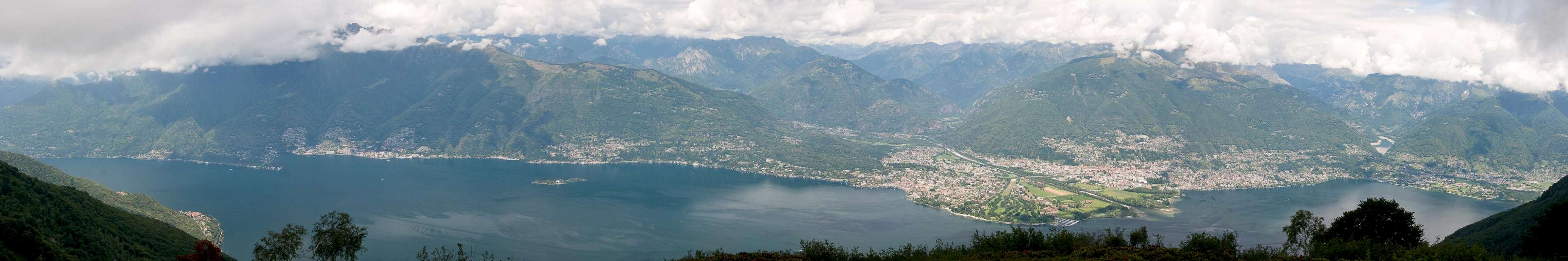
The Lago Maggiore Panorama
  |
Getting There
Trailheads for Monte Paglione, Covreto and Sasso Corbaro are at Indemini and Monti di Gerra. They all can be reached from the shores of Lago Maggiore by steep and sometimes very narrow mountain roads.- Take the Gotthard Motorway A2 to the exit Bellinzona Sud
- Switch to A13, direction Locarno.
- At Quartino turn off left (two roundabouts) in direction Magadino, Vira
- For Indemini leave the lakeshore road at Vira (signs for Indemini). Cross Alpe di Neggia and head on to the small mountain village.
- For Monti di Gerra stay on the lakeshore road until you reach Gerra. From here a narrow mountain road takes you to the Monti.
Red Tape
 Yours truly taking a bath in alpenroses on Monte Paglione
You are in the border region between Switzerland and Italy. Both ratified the Schengen treaty so there are no border controls. But be sure to bring an ID just in case.
Accommodation
There is plenty of accommodation to be found on the web, mainly apartments or holiday homes. However, Tessin / Ticino has become very expensive so you will have to carefully plan your vacation. Most expensive are the cities (Lugano, Locarno, Ascona) but also the villages on the shores of the lakes can burn deep holes in your pockets. In general the higher up and the better the view the more expensive.A good alternative is agritourismo - farm holidays, either in the valleys or in one of the spring / autumn settlements at an elevation of around 1000m.
You can find accomodation of any type using the following url:
http://www.ticino.ch
Weather Conditions
Maps & Books
Maps
- Digital Maps
- Regular Maps
- Malcantone
Carta Escursionistica 286 T
Ufficio Federale di Topografia Swizzeria
1:50.000
ISBN: 9783302302867
- Malcantone
Books
- Tessin
M. Hempel
Kompass Guidebook WF997
Kompass Verlag
ISBN: 3-85491-771-6
- Tessin
H. Bauregger
Rother Verlag
ISBN: 978-3-7633-4078-1
- Tessin
E.E. Hülsler
Bruckmann Verlag
ISBN: 978-3-7654-3653-6