
|
|
Mountain/Rock |
|---|---|
|
|
46.36292°N / 8.84348°E |
|
|
Verzasca |
|
|
Hiking, Mountaineering |
|
|
Spring, Summer, Fall |
|
|
8917 ft / 2718 m |
|
|
In memory of:

Summit...

Pizzo Cramosino in snow
This page was made with the great help of SP member Cyrill Rüegger , who tragically died in an accident on Piz Palü on June 13th, 2009.
Rest in peace Cyrill, you will be missed.
---------------------------------------------------------------------------------------------------------------------------------------------------------------------
OVERVIEW
Pizzo Cramosino is a wonderful pyramid shaped peak located in the Val Verzasca region of Ticino, Switzerland. With its 2718m of altitude it is also one of the highest peaks peaks of the region. Only Monte Zucchero (2735m) and Madom Gross (2741m) are higher. The last one named, is in fact Cramosino's bigger brother located just west of it, with a sharp ridge that joins the two mountains together.
Pizzo Cramosino is not regularly ascended. Climbing this peak goes hand in hand with quietness and enjoying the wild nature of the Verzasca region. The climb is graded T4 and is therefore easier then its bigger brother Madom Gross (T6). Being somewhat underexperienced for Madom Gross, then Pizzo Cramosino is a great destination.
Summit views are great; to the west you can see the ridge that connects Cramosino to Madom Gross. Towards the east you can see the upper Leventina Valley. Towards the south you have a spectacular view into the upper Verzasca area.
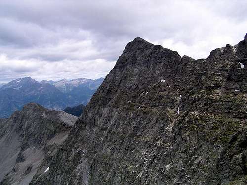 Pizzo Cramosino (2718m) and its steep North Face Pizzo Cramosino (2718m) and its steep North Face |
Route

Rifugio Costa

Typical Swiss House
The route starts in the village of Frasco at an altitude of 885 meters. From here a marked trail starts towards the east leading into the forest. You will follow the trail up to Refuge Alpe Costa (1941m), where it is possible to spend the night since the ascent involves a height gain of almost 2000 vertical meters.
From this point on a white-blue-white marked trail leads you up to the ruins of Laghetto at 2050 meters.
You will continue to follow this white-blue-white marked trail in an eastern direction until point 2059. This part is quite flat and crosses the south flanks of Madom Gross and Pizzo Cramosino from west to east. At point 2059 the road splits up. Take a left and follow the trail going north. You will start to elevate and the route keeps going in a northern direction all the way to the summit of Pizzo Cramosino at 2718m.
Descent is the same way back.
But a nice variant is available. You can traverse from Cramosino to its higher neighbour Madom Gross. This is done over the ridge that leads towards the west from Cramosino to Madom Gross. From Madom Gross you descend down to Laghetto at 2050m and further back to Frasco. This variant is graded T6 and especially the descent from Madom Gross summit down to Laghetto is steep and difficult and therefore requires advanced alpine experience.
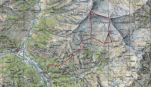
Route Map
Area Overview Map
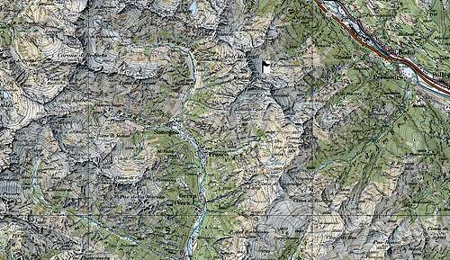
Getting There

Pizzo Cramosino

Pizzo Cramosino
The A2 highway crosses Switzerland from north to south. On this highway take exit 'Locarno'
Follow the Locarno signs for several miles on this secondary road.
After a few miles there will be signs saying: Val Verzasca. This will lead you to Val Verzasca.
In the Verzasca valley is only one major road. You follow this road and you will first pass the village of Vogorno, than you will pass Lavertezzo and the 3rd major village is Brione. Here the road splits up: Follow the road to the east towards Gerra, Frasca and Sonogno. When you reach the village of Frasca park your car. In this very small village a hiking trail starts towards the east. This is the starting point for the climb.
Practical Information

Val Cramosino
Climbing Pizzo Cramosino does not involve any gear. The climb is graded T4 Some alpine experienced is advised.
Note:
The altitude difference from the valley floor (staring point) until the summit is quite large. The climb includes an elevation gain of over 2000 vertical meters. Therefore, a good physical condition is advised.
Camping & Hotel
Camping Al Censo, Claro.A beautiful campsite on less than half an hour drive from Verzasca.
For more info:
camping Al Censo
The nearest Hotel is in Vogorno:
Hotel Pizzo Vogorno
Weather & Links
Click for WeatherVal Verzasca Tourist office
6598 Tenero
Tel +41 (0)91 745 16 61
Info@tenero-tourism.ch
www.tenero-tourism.ch
Official Ticino Site