Overview
![Val Piora lakes from below Taneda]() The lakes of Val Piora - one of the most delightful views on the round hike
The lakes of Val Piora - one of the most delightful views on the round hike
, 3019 m, consists of a few 3000-ers and stretches between the famous
St. Gotthard Pass on the west and also already since the Ancient Roman times used
Passo del Lucomagno on the east. From the main crest many side ridges go towards the north, but south of it stretches a nice high mountain area with valleys oriented in the west-east direction. A special characteristic of St. Gotthard mountains is abundance of lakes, which is not unusual, as the whole area is predominantly built of solid granite. The majority of them lies in these two valleys and their high basins. These are the valleys of
Val Cadlimo and
Val Piora. Then further towards the south the last ridge stretches above the deep
Valle Leventina, culminating in Pizzo del Sole, 2773 m.
Just in the middle of the area which is most densely dotted with nice lakes, a not much spectacular mountain rises, reaching only an altitude of 2667 meters. Even if the mountain itself is nothing special, it is a nice hiking goal and on any route on its top you can experience a most beautiful Tessin/Ticino landscape.
As the lower area is easily reachable, at least from the south, from Valle Leventina, by the lakes many people simply spend time, doing easy
hiking around. Only 800 m higher, visitors are already rare. And even they mostly go by the marked paths, which connect huts. The summit of Pizzo Taneda has a lot of big cairns, but much less visitors. It is mostly visited by hikers who include the short summit ascent into a broader hike over the high saddles. That's what we did as well. In winter, the summit must be a nice goal for skiers, only that Val Cadlimo does not end very nicely near Passo del Lucomagno. And, it is not a secret, the whole area is very rich with minerals, which can also attract some visitors.
Lago Cadagno
![Lago Cadagno]() Lago Cadagno
Lago Cadagno | ![Cadagno di Dentro]() Cadagno di Dentro
Cadagno di Dentro | Lago Cadagno is a meromictic lake in the Piora valley. First time met this term? Me too, so I researched further and learned that these types of lakes have layers of water that do not intermix. A set of pre-conditions must be met, first of all deepness and lack of outside influence (stronger water inflow, wind etc.). That is why lower layers stay on the bottom, keeping in their contents also interesting history of the past ages. As these lakes are rare and have also specific fauna and flora, also Lago di Cadagno is often studied by scientists. |
Summit Views
Its central position enables Pizzo Taneda nice views on the nearby mountain area, but only towards the west and south views are flying far. There are the high mountains west of St. Gotthard and south of them the broad area of Tessin/Ticino mountains, with Basodino, Cristallina, Pizzo Campo Tencia and other summits. As even in the ridge between Val Cadlimo and Val Piora Pizzo Taneda is not the highest summit (east of it Schenaduei, 2747 m, is higher), those views are a bit obscured, and so are of course the views towards the north, on the not so attractive southern slopes of Piz Blas and its neighbouring 3000-ers.
![Pizzo Taneda]() The summit
The summit | ![The great Val Piora panorama]() Great is the view from below Pizzo Taneda over Val Piora and its lakes!
Great is the view from below Pizzo Taneda over Val Piora and its lakes! | ![Val Cadlimo from Pizzo Taneda]() Eastern views
Eastern views |
Getting There
![Passo del Lucomagno]() Passo del Lucomagno
Passo del LucomagnoA big majority of Taneda visitors come in the area from
Valle Leventina, using the
funicular from Piotta, 786 m. On the length of 1369 m it makes 785 m of elevation gain and is so with 87,8% gradient one of the steepest in the world. The funicular brings you close to the southern shore of
Lago Ritom, which is on 1850 m of altitude. But there also a
mountain road reaches, continuing as high as to
Cadagno lake, 1921 m.
The second good starting point for tours on Pizzo Taneda is
Passo del Lucomagno, 1915 m. There starts a very nice round tour on which we can combine visits of Val Piora and Val Cadlimo.
Ascent Routes
![Taneda map]() Click here to see the on-line map!
Click here to see the on-line map!On a special page I will describe the beautiful round tour from Passo del Lucomagno. It combines the two routes with starting point on that saddle. The third route is from Lago Ritom and is in the upper part identical with the Val Piora route. Here is only basic information:
- From Passo del Lucomagno through Val Cadlimo. Passo del Lucomagno (1915 m) - Lai da Sontga Maria SW shore (1924 m) - Stabbio Nuovi in Val Cadlimo (2250 m) - Motto del Isra (2379 m) - Pizzo Taneda (2667 m). 3 h 30 min, mostly easy hike up (T3).
- From Passo del Lucomagno through Val Piora. Passo del Lucomagno (1915 m) - Lai da Sontga Maria SW shore (1924 m) - Passo dell'Uomo (2218 m) - Val Piora, Cadagno di Fuori (1917 m) - Saddle towards Lago di Tom (2077 m) - Laghetti di Taneda (2248 m, 2304 m) - Saddle towards Lago Scuro (2477 m) - Pizzo Taneda (2667 m). 4 h 30 min, mostly easy hike up (T3).
- From Piotta funicular. Upper station of funicular (1794 m) - Alpe Ritom (1891 m) - Lago di Tom (2222 m) - Laghetti di Taneda (2248 m, 2304 m) - Saddle towards Lago Scuro (2477 m) - Pizzo Taneda (2667 m). 2 h 30 min, mostly easy hike up (T3).
Just a comment regarding the summit ascent: It goes by the northern slopes, which are easily passable. The path is beaten by the eastern shore of Lago Scuro. Not much harder is the pathless ascent by the western ridge.
Images From the Pizzo Taneda Round Tour
Below is just a set of images from the nice round tour, combining the above Val di Piora and Val Cadlimo routes. See a detailed route description on the child page!
![In Val Piora]() In Val Piora
In Val Piora | ![Lago di Tom]() On Motta hill
On Motta hill | ![Lago di Tom]() Lago di Tom
Lago di Tom | ![Laghetti di Taneda]() Laghetti di Taneda
Laghetti di Taneda | ![Lago Scuro]() Lago Scuro
Lago Scuro |
Mountain Huts
![Capanna Cadagno]() Capanna Cadagno
Capanna Cadagno- Capanna Cadagno, 1987 m. Opened whole year, but only from the start of June till the end of October you can get there full service. Access: From Von Ambri-Piotta with funicular to Ritom, then on foot. 1 h 30 min. From Passo del Lucomagno over Passo dell'Uomo. 2 h 30 min. By car: From Piotta via Altanca, 1 h 30 min.
- Capanna Cadlimo, 2570 m. It stands on the pass above the end of Val Cadlimo, just north of Pizzo Taneda. It is accessible from Passo del Lucomagno by the same marked route, as described for the ascent on Pizzo Taneda. Good 3 hours of walk up.Add External Links text here.
Red Tape
No special restriction in the nearby area.
When To Climb?
![Descending Pizzo Taneda]() Snow rests in August
Snow rests in August![Near Lago Cadagno]() Summer near Lago Cadagno
Summer near Lago CadagnoPizzo Taneda can be climbed any time of the year. In winter it is to consider if in deeper snow the southern ascent is safe. The northern side is ideal for skiing, but Val Cadlimo probably does not end very nicely for skiing.
Your Help Is Needed
If you visited the area, the following additional information is mostly needed:
- Any experiences from tour skiing.
- Pictures from winter time.
- Other ascent routes on Pizzo Taneda (from the east, scrambles, ...

 6458 Hits
 82.48% Score
 15 Votes
 The lakes of Val Piora - one of the most delightful views on the round hike
 Lago Cadagno
 Cadagno di Dentro
 The summit
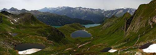 Great is the view from below Pizzo Taneda over Val Piora and its lakes!
 Eastern views
 Passo del Lucomagno
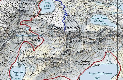 Click here to see the on-line map!
 In Val Piora
 On Motta hill
 Lago di Tom
 Laghetti di Taneda
 Lago Scuro
 Capanna Cadagno
 Snow rests in August
 Summer near Lago Cadagno