
-
 19956 Hits
-
 89.39% Score
-
 29 Votes
|
|
Mountain/Rock |
|---|---|
|
|
40.24162°N / 9.49162°E |
|
|
Hiking, Trad Climbing, Scrambling, Canyoneering |
|
|
Spring, Summer, Fall |
|
|
1699 ft / 518 m |
|
|
Overview
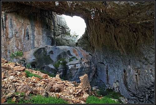
Within Monte Tiscali chasm

From the distance

Tiscali chasm
Geographically Monte Tiscali rises between the valley of Rio Flumineddu and Lanaittu valley, closer to the latter.
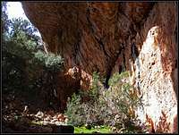
Tiscali Village
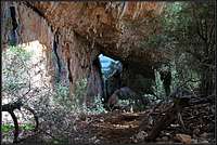
Under Tiscali walls
The village remains
Tiscali village originates far back in the prehistorical times, but most of its artifacts are from the period between 6th and 4th century b.C. It is located just below the summit of Monte Tiscali, in a spectacular chasm. The whole underground cave collapsed once, creating a huge crater with vertical inside walls almost all around. The majority of houses was just below the abysses and around a natural window where once also there was an entry into the cave. The whole complex is an ideal natural fortification, offering a shelter to the Nuraghe people against Roman invadors. But life had to be hard in that wilderness, one of the biggest problems was probably enough water supply. Explorations are still underway. From May till September, 9:00-17:00, the entry into the site must be paid. The fee is 5 EUR or 3 EUR (discounted), guidance included. We arrived there before 9 a.m., entered the site, but when exiting, the guard was alread there, charging me, who am allways slow due to taking photos, while Jasmina somehow left unnoticed.
Getting There
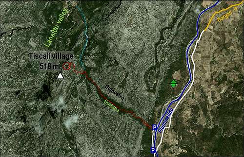
Both valleys in which traileads are, can best be reached from Dorgali town, which lies in the mountaneous eastern part of Sardinia. Dorgali can be reached by the SS125 state road, going south from Orosei. Once in Dorgali, you have two options: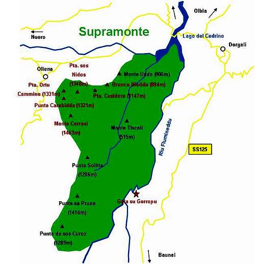
1. Lanaittu valley approach. From Dorgali you drive westwards (or from Nuoro and Oliena eastwards) and then towards Lanaittu valley until you reach the Hotel at Sorgente Su Gologone (beautiful, strong water source). From there continue soutwards into Lanaittu valley until the crossroads, where the right road goes to Grotta Sa Oche (cave). Take the left branch and drive until the road becomes too hard for usual cars. Till here you can follow inscriptions (Tiscali).
 |
2. Valley of Rio Flumineddu approach. From Dorgali continue southwards by the panoramic road SS125. Soon after the tunnel which could take you left through the mountain ridge and down to Cala Gonone (beach) you will notice a narrow road deterring right down into Flumineddu valley (on the main road there's an inscription: Tiscali). Descend into the valley and continue by iz (SW direction) until the road gets quite bad. Proceed by it to Ponte S'abba Arva (bridge) after which two cart roads go left an right. The left road goes towards Su Gorropu canyon, while the right cart road goes down the valley (by the left bank) towards a shepherds hamlet (a distinct crag of Monte Tondu above it). You can drive by it some more 800 meters and park among bushes, where the trailhead to Monte Tiscali is (inscription on the table).
 |  |  |
Routes Overview
A sketch of the area
1. Lanaittu route
From the place where you left car, continue by a dry creek bed, following blue marks. In good 30 minutes you will reach the branching, where from the SE the Flumineddu approach comes. (I haven't done this part of the route.) On the tree there is a clear inscription (Tiscali) and the warning that the entry to the village must be paid. From then on you follow red triangular marks. The path winds in turns towards the west and north-west, you pass a picturesque cave and quickly gain altitude. Some 150 meters of ascent are strenuous, but not dangerous. Just some secure step is required and if you are with children, take some care of them. Above, the path reaches a panoramic balcony and soon behind the corner the entry into the village. |
2. Flumineddu route
From the parking place above the Flumineddu river you follow a well marked path up towards the north-west. The steep ascent brings you after some gained 200 meters of altitude into the beautiful S'Iscala e Surtana (Surtana gorge). The valley is cut into the mountain ridge in the SE-NW direction, steep walls are rising on both sides. Especially the walls on the right (Doloverre) are almost vertical, and are very popular with classical climbers (they usually sleep in tents down at Flumineddu river). After good 1h (at the end of Surtana gorge we descend some 70 meters) of walk we reach the crossroads on a clearing where the Lanaittu ascent comes up. There turn left and as described in the previous paragraph, ascend in less than 30 minutes to Tiscali village. |  |  |  |
Red Tape

Camping
Camping in the valley of Flumineddu river is forbidden. I am not aware of specific regulations, but due to remoteness I guess nobody will chase you if you set up a tent at trailhead over the night. We slept in car near Ponte S'abba Arva (bridge) and next morning found on the trailhead above Flumineddu river a group of climbers sleeping there over the night in a few tents. Otherwise the nearest tourist facilities are in Dorgali.Because the whole hike will not take you more than 4 hours, you don't need to sleep in those mountains, unless doing more treks in the area.