Page Type Page Type: Mountain/Rock
Location Lat/Lon: 40.26190°N / 9.43980°E
Additional Information Elevation: 4423 ft / 1348 m
Sign the Climber's Log

Overview


Punta sos Nidos photo_id=89855

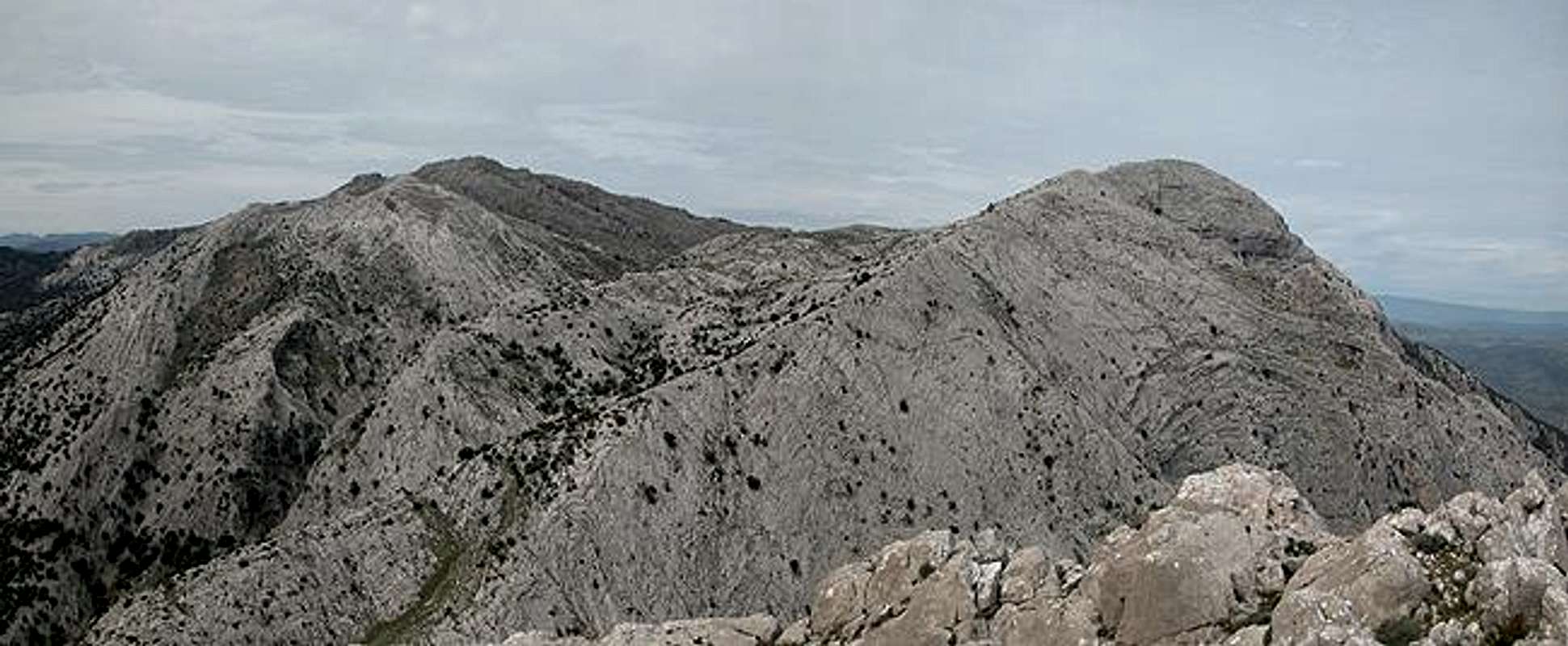
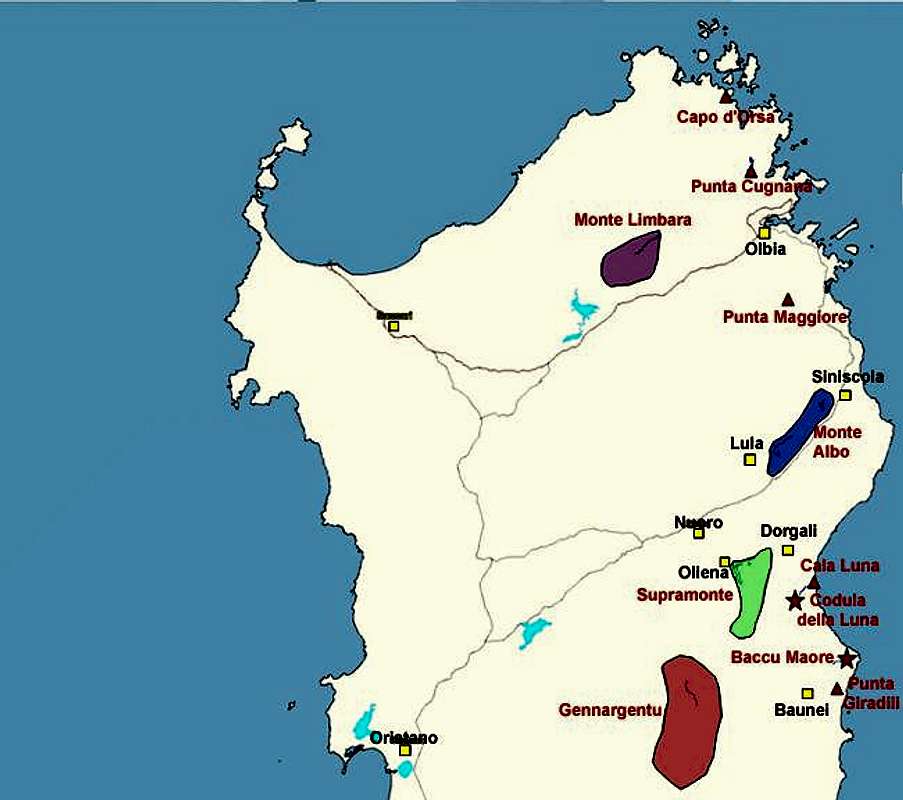
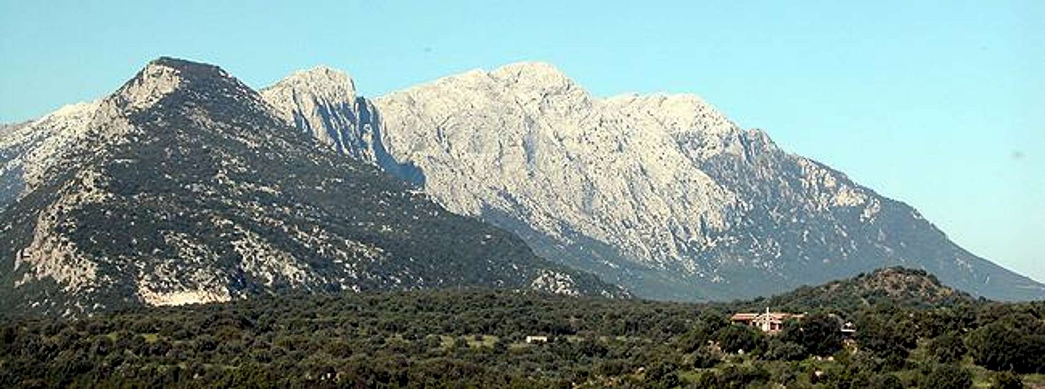
Punta sos Nidos is the highest summit in the north face of the Supramonte Mountain Range in Sardinia / Sardegna. Rather unspectacular to look at it is a great lookout summit - probably the best within the range. Its location between Punta Carabidda and Punta Ortu Camminu to the west as well as Punta Cusidore and Bruncu Nieddu to the east makes it a perfect mountain to catch pictures of these mountains. To the southwest there is Supramonte's highest summit, Monte Corrasi, which surmounts sos Nidos by about 150m.

To the north of the Supramonte Range stretches the long chain of the Monte Albo Massif. Both mountain ranges are closely related - in fact were part of a single mountain region but due to tectonic movements of the earth's crust drifted away from each other by about 40km. Even worther to the north east there is Tavolara Island, which also shows the same kind of limestone rock formations with vertical walls.

Punta sos Nidos is relatively easy to ascend from the western side by hiking the forest road to Scala 'e Pradu and then hopping along the spiky rocks on the Spramonte high plateau. The eastern ascent along Scala di Sovena is much more demanding, the Scala being a large gravelly couloir which demands serious attention from each hiker. Once in the saddle east of Punta sos Nidos, the karst hopping also begins but with a rather larger elevation difference to surmount.

Gola su GorropuMonte CorrasiPunta CarabiddaPunta Ortu CamminuPunta sos NidosPunta CusidoreBruncu Nieddu

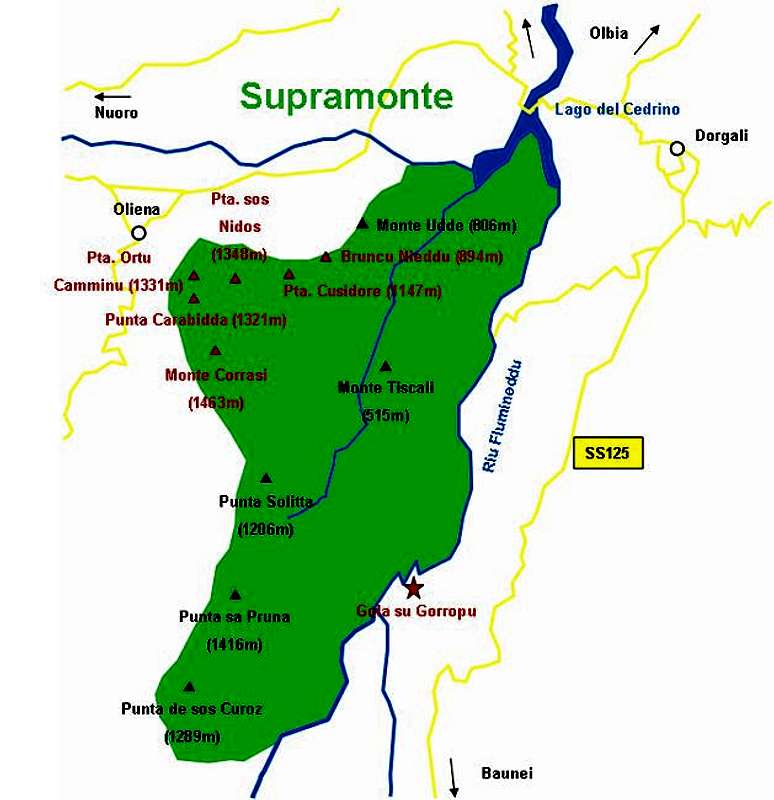
Interactive overview Map of Supramonte. The summits (and gorges) which have been submitted to SP are marked in red.

Getting There


Punta sos Nidos photo_id=90119

Sardinia can be reached either by plane or by ferry. The main ports are Porto Torres and Olbia in the north and Arbatax and Cagliari in the south. Airports are at Alghero and Olbia in the north as well as (again) Arbatax and Cagliari in the south. For exploring the north eastern part of the island where most of the mountains are the best entry point is Olbia, which is where most flights go anyway.

Approaching the mountain from Olbia airport
Get on motorway SS 131 south in the direction of Siniscola / Nuoro. At the exit Lula / Dorgali get off and turn on SP38 south (again direction Dorgali). Shortly before you reach the town turn right on SP46, direction Oliena. In Oliena follow the signs to Monte Maccione, which - if I understand correctly - is the larger mountain of which Punta Carabidda is a part of. The road leads to a restaurant at which you can park your car.

Capo d'OrsaPunta CugnanaMonte LimbaraPunta MaggioreCala LunaPunta GiradiliMonte AlboSupramonteGennargentuCodula della LunaBaccu Maore

Interactive map of Sardinia and its mountain regions. Click on the regions, red triangles (mountains) or stars (gorges).

Red Tape


Punta sos Nidos photo_id=89864

Punta sos Nidos - like all other Supramonte summits - is part of the natural park Gennargentu / Golfo di Orisei. The usual restrictions concerning wildlife apply here and camping is strictly forbidden. For a small fee the proprietor of the Monte Maccione Restaurant will let you camp in the restaurant garden however. You'll probably meet a lot of climbers there since Supramonte and Monte Maccione are among the most popular climbing destinations of the island.

Punta Sos Nidos  photo_id=89866Punta Sos Nidos  photo_id=89864Punta Sos Nidos  photo_id=89873Punta Sos Nidos  photo_id=89874

When To Climb


Punta sos Nidos photo_id=90097

No restrictions here. In summer go for the Supramonte north faces, otherwise it'll be too hot. Hikers should start out early in summer to get to Scala 'e Pradu before the sun comes up over the mountain. Once upon the high plain you'll find no shelter from the sun anyway.

Best seasons are spring and autumn.


Punta sos Nidos  photo_id=89872Punta sos Nidos  photo_id=89850Punta sos Nidos  photo_id=89854Punta sos Nidos  photo_id=89833

Accommodation


Accommodation...
...is rather easy to find. Since all the interesting mountainous regions are on the north and east coast - which is where the largest beaches are - you can book hotel rooms and apartments from any tourist office. The region around the towns of Siniscola, Dorgali and Orisei should be the best staying places since they are rather central to most of the interesting locations. If you prefer climbing on the coast, head for Cala Golone.

Camping...
... is also easy to find in the vicinity of the beaches. Look for locations, using www.sardegna.com. Free camping in the natural park is not allowed. At the base of Monte Maccione above Oliena there is the restaurant "Monte Maccione" in the garden of which you can place your tents after asking the proprietor.

Weather Conditions


Go for the following link, which is in Italian but with ALL the information you might want to have on weather on the island:

www.sar.sardegna.it.

Head for the "Bollettino dettagliato" link.

Maps 'n' Books


As for Maps I used only a road map scale 1:200000 since the guidebook I used has maps and is really quite good. Don't be fooled by the durations they state, you'll be much faster but the "getting there's" and "route description's" are very good.

The book is:


Sardinia (Sardegna / Sardinien)
M. Omidvar
Rother Verlag
ISBN: 3-7633-4800-X (English)
ISBN: 3-7633-4143-9 (Italian)
ISBN: 3-7633-4023-8 (German)


Children

Children

Children refers to the set of objects that logically fall under a given object. For example, the Aconcagua mountain page is a child of the 'Aconcagua Group' and the 'Seven Summits.' The Aconcagua mountain itself has many routes, photos, and trip reports as children.

Parents 

Parents

Parents refers to a larger category under which an object falls. For example, theAconcagua mountain page has the 'Aconcagua Group' and the 'Seven Summits' asparents and is a parent itself to many routes, photos, and Trip Reports.

SupramonteMountains & Rocks