
-
 8223 Hits
-
 79.78% Score
-
 11 Votes
|
|
Mountain/Rock |
|---|---|
|
|
46.43999°N / 10.07893°E |
|
|
Livigno Alps |
|
|
Skiing |
|
|
Spring |
|
|
10036 ft / 3059 m |
|
|
Overview
The top, perfectly symmetrical, is placed on a circular base consists of gentle slopes.
The “Valle della Forcola” and “Vallle da Campo” surround it almost totally.
Its southern ridge, almost flat, takes to the neighbour “Pizzo Ursera” 3032m.
It is entirely placed in Italian territory, but not far from the swiss "Passo del Bernina".
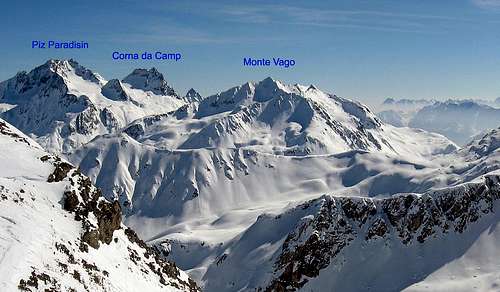
Despite the modest elevation (3059m), remains the most impressive mountains around Livigno, exept for the highest "Piz Paradisin" and "Corna da Camp" but hidden if seen from the village.
It’s commonly climbed in all seasons, for its simple approach, but especially by skiers due to its beautiful north-facing slopes. Funny its west ridge, slightly sharp.
The name "Monte Vago" comes from the local dialect. It can mean: “mount desolate” or “mount abandoned”.
The mountain is in a fairly secluded area and free from shelters or bivouacs.
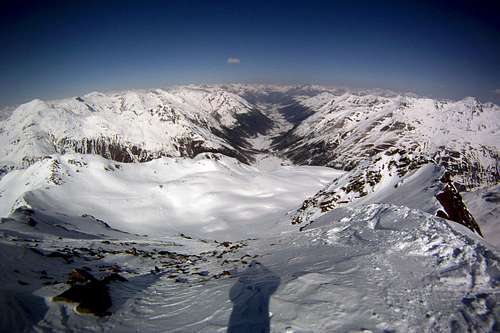
The valley of Livigno seen from the summitGetting There
From Switzerland: Line Zernez-Livigno Silvestri Bus
From Italy: Line Bormio-Livigno Bus Perego or APT Livigno
By Car:
From Switzerland: St.Moritz-Livigno Tunnel "Munt la Schera"
or Tirano/St.Moritz - Livigno - Passo della Forcola (open only in summer)
From Italy: Milano-Sondrio-Tirano-Bormio SP38 - Passo del Foscagno - Livigno SP301
The ski route
During the winter the road for the "Passo della Forcola" is closed for cars, by a barrier placed near the hamlet "Campacciolo di Sopra" 1900m.
From the barrier, follow the paved road for 1.5 km. On the left side of a small bridge, a road usually covered with snow, leads to a flat meadow called '"Alpe Vago" 2000m.
A second wooden bridge allows to bypass the river that descends from the "Valle di Campo" and permits to reach the left watershed of the valley at the foot of Monte Vago.
It is also possible to go along the valley, but the overcoming of the river would be more complicated.
Go up the steep slopes on your right, until you can see the entire "Valle di Campo" and the NW side of “Piz Paradisin”.
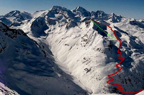
The ski route. The green dots is the descent from the summit
Do not enter the valley, but turn to your right side over the slopes on the north side of the mountain (Livigno side).
Continue easily until the snowy basin at the base of the summit.
Than simply point to the west ridge and when it reached you have two choices of approach:
Leave your skis close to the first rocks, and continue along the ridge with axe and crampons (PD in winter).
Or carry the skis on you until the summit cross, and descend directly from the steep north wall with a slope of 45°/50° and a vertical drop of 100m (S5).
During the summer, the usual route start form the "Passo della Forcola" 2315m, along the path n.102 (EE)