
-
 12360 Hits
-
 83.1% Score
-
 16 Votes
|
|
Area/Range |
|---|---|
|
|
45.68925°N / 11.14230°E |
|
|
Hiking, Mountaineering, Sport Climbing, Scrambling, Via Ferrata, Canyoneering, Skiing |
|
|
Spring, Summer, Fall, Winter |
|
|
6483 ft / 1976 m |
|
|
Introduction
 On Monte Castelberto
Monti Lessini is a montaneous area, a part of Prealpi Venete e Trentine, which is not always uniquely defined. Often under this term people understand also the neighbouring group of Piccole Dolomiti (Cima Carega, Monte Obante, Monte Cornetto). But they are different than Lessinia. While the mountains of Piccole Dolomiti are rugged and rocky, in Monti Lessini at least on the southern sides broad, grassy slopes prevail. As on SummitPost we already have the page of Piccole Dolomiti, I will here describe only the genuine Lessinia. But some dilemmas of bordering still remain ...
 The high plane The high plane |
 Lessinia Lessinia |
Boundaries

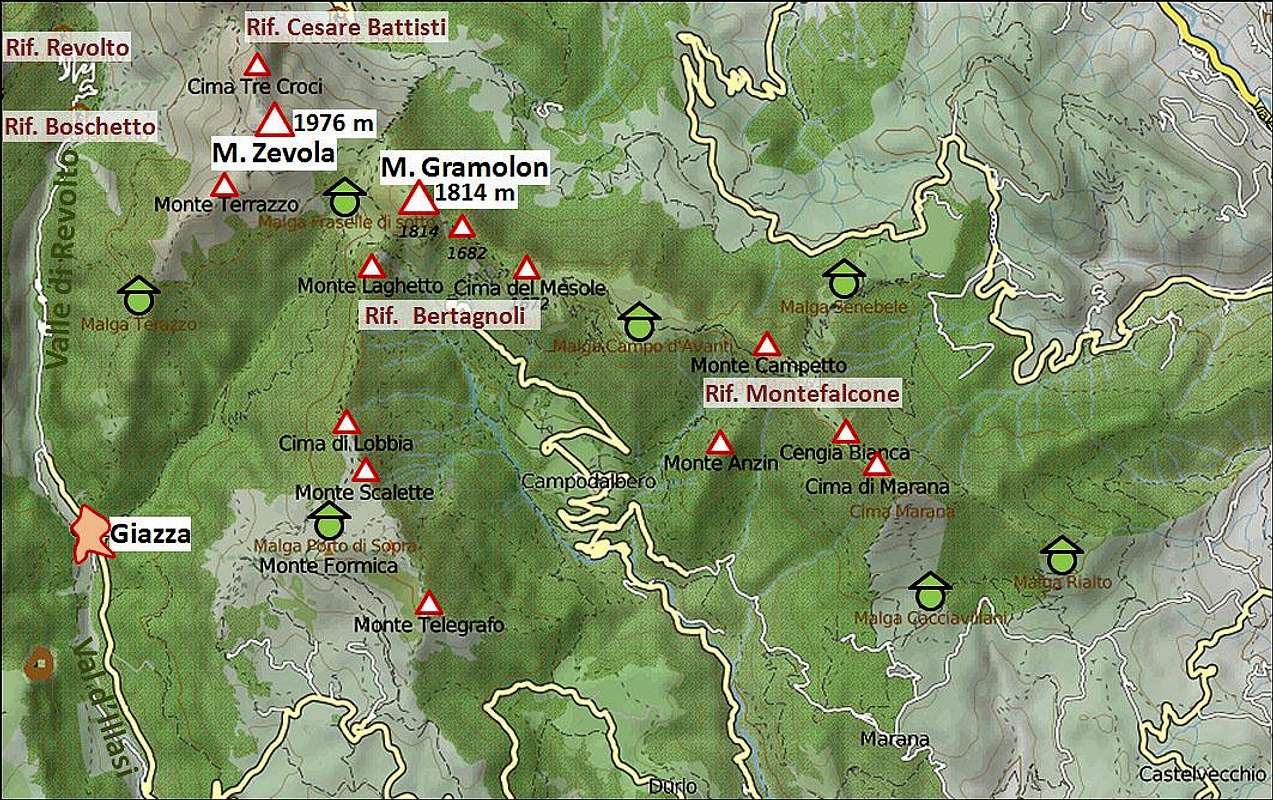
Monti Lessini are the southernmost group of all Eastern Alps. They rise just north of Verona and northwest of Vicenza. From the space they appear like a huge shell. Many long ridges and valleys come together on the northern ridges. The western ridge appears more like a huge plateau stretching on the altitude around 1700 m. Towards the south and southeast the ridges lower just to the big Po river plane. Verona lies on the altitude of just 60 m above the sea level. While the southern border of Monti Lessini is the plane, on the west the border is Adige valley. This river, coming from the north, makes a turn around Monti Lessini and then continues flowing towards the southeast, through Verona and towards Adriatic sea. Beyond Adige on the west is the group of Monte Baldo and Garda lake. On the north, the deep Val Ronchi rises from Adige into the massif. It delimits the narrow Lessinia from Cima Carega group. And on the east we have a small issue. From the groups of Carega and Obante strong ridges are lowering towards the southeast, changing its character. So, where to draw the border? While on the southern sides these mountains have all characteristics of Lessinia, a few summits on the north are steep and rocky, much more like to Piccole Dolomiti. For practical reasons let's draw the border on Passo della Lora, 1716 m, leaving Monte Zèvola, 1976 m, in Lessinia. Going one pass further towards the southeast would not make the situation any clearer. Monte Gramolon, 1814 m, is still rugged and rocky, but already quite away from Piccole Dolomiti. Further on the east let's finish our description of Lessinia in Valdagno (valley), leaving much lower hills between it and Schio neglected.
The Mountains of Lessinia
The summits, worth of ascending, are mostly in the northern part of the group. Some lower, but still quite panoramic summits are also on the western edge, just above the river of Adige. The broad grassy northern plateau soon gets cut by many valleys and the ridges, dividing them, become partly forrested. They are still very panoramic and driving by them (or riding by a bike) is a pure pleasure. Alpine pastures become more cultivated and on some 1200 m villages and small towns begin. In the lower parts you will see many orchards (famous is Valpolicella), olive trees plantations and vineyards. Nature is being degraded only by many wounds in slopes, where the famous red marble is being cut. But on the other hand, marble and stone masonry gives a wonderful, very characteristic flavour to Lessinia.
Eastern Part
East of the deeply cut Val d'Illasi is the strong ridge of Monte Zèvola and Monte Gramolon. Later this ridge branches. It's high mountains are very nice mountaineering goals, the ascents are not all just easy and in the rocky face of Monte Gramolon you will even find a popular 'via ferrata'. On the southern slopes there are not so broad plateaus, but many of them are open and grassy, with nice alpine meadows. Other slopes are forrested. From the northeast these mountains are reachable from the spa town of Recoaro Terme. Some good mountain roads go up and there is also a cable way to Monte Campetto. From the southern side many mountain roads ascend towards the summits by valleys and by gentle ridges.

Central Part
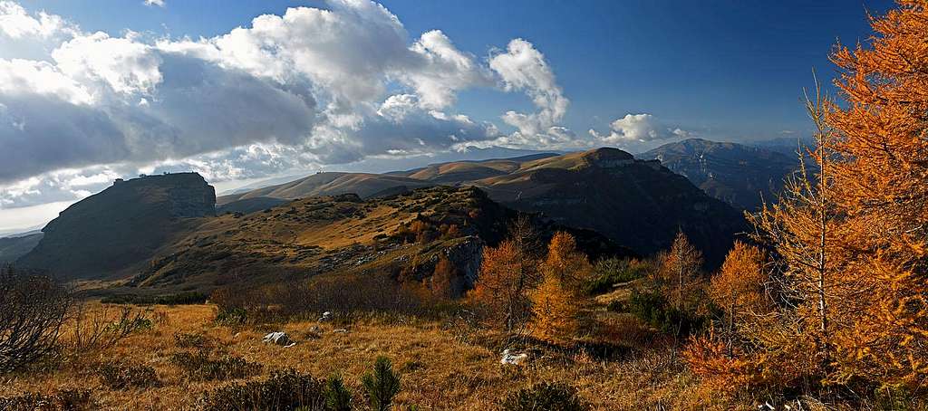
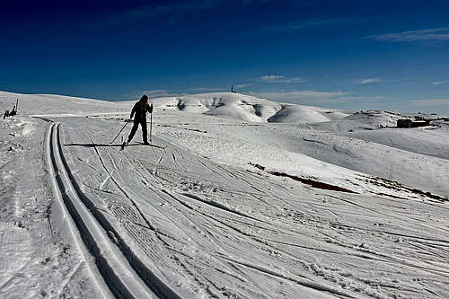
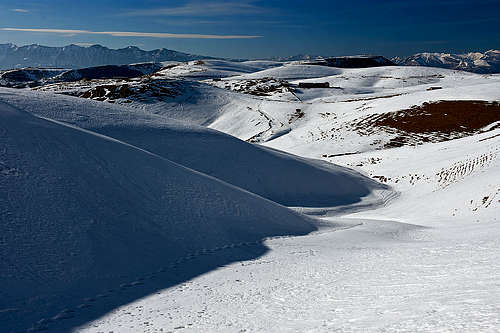
The summits of central part all gently rise above the broad, grassy upper plateau of Lessinia. In most cases the altitude differences are even below 100 meters. Towards the north, their slopes are falling much steeper into Val Ronchi. On the east, just above Val d'Illasi, the first higher summit is Cima Trappola, 1865 m. The nearby Castel Gaibana can be reached by a chair lift from the tourist center San Giorgio. The next higher summit towards the northwest is Monte Sparavieri, 1797 m. It is nice an panoramic, reached from the road in some 20 minutes. South of it, in the middle of the plateau, is the grassy dome of Monte Tomba, 1766 m. A mountain road reaches it, in winter it hosts ordinarry ski terrains with a few chair lifts. Further on the north west there is the elevation of Monte Castelberto, 1765 m. A cart road reaches it's top where also a mountain hut stands. On the very west let's mention also Monte Cornetto and Corno d'Aquilio, both 1545 m. They are both nice hiking goals due to panorama. In the western part a good road crosses the plateau and the whole Lessinia, going from the south and over Passo Fitanze, 1393 m, northwards down to Adige. On the east, a good road reaches San Giorgio tourist resort, 1480 m. From this one two mountain roads go across the plateau towards the west. The notheastern one is closed for public traffic, but is great for biking. The southwestern road however connects many alpine pastures (malge) and is open for public traffic. It detours Monte Tomba by the western side and then continues westwards just to Passo Fitanze. These are great biking terrains! You can do various tours, visit picturesque alpine meadows and from San Giorgio do also a round tour. And even more. In winter time the whole plateau converts into a paradise for cross country skiing. The well maintained tracks go just by the mentioned roads and also by many others. Otherwise, the summit plateaus of Lessinia can be reached by many roads which start in the vicinity of Verona.
Western Part
These are the summits above Adige. They mostly reach altitudes around 1000 m and because of nice panoramas, many marked paths (and also mountain roads) reach their summits from all sides.
Geology
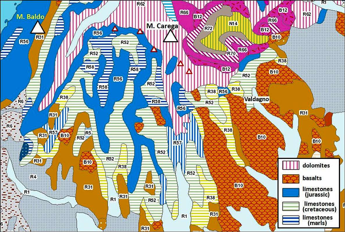
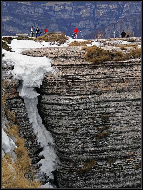
On the geological map on the left you can see why such a big difference between Monti Lessini and Piccole Dolomiti. The latter are build of Triassic dolomites rocks, while Monti Lessini are mostly made of limestone. You can clearly see that the dolomitic platform stretches also towards the southeast, on Monte Zèvola and Monte Gramolon. So, geologically, the above dilemma could be easily resolved - the chain, continuing from Monte Obante towards the southeast should be included into the group of Piccole Dolomiti. Even more towards the southeast there is a broader area of volcanic rocks. Those are Miocenic alkaline basalts. Those mountains are already low and less interesting for us, but in the area we can visit a few nice areas of basalt rock formations. The majority of 'true' Monti Lessini is built of various limestone rocks. On the map you can see quite broad areas of marly limestones from the Jurassic period, micritic limestones from the Cretacious and Upper-Jurassic period and limestones (and partly dolomitic rocks) from Jurassic period. The limestone platform of Lessinia is responsible for abundance of karst phaenomena in the area. Sinkholes, unusual eroded rock formations, limestone rock windows and arches are very valuable objectives of visits!
What To Do There?

Lessinia as a whole is first of all a tourist destination, very suitable for just driving around and sightseeing. We shall mention some nice places in lower parts of the massif. Nice hikes can be done, from just short walks to longer and more enduring tours. The higher summits in the eastern part offer also some more challenging tours. For climbing some crags are appropriate. Then here it's mountain biking and in winter cross country skiing. Especially across the upper plateau, the tours are really nice. Other outdoor activities are possible too.
Getting There
 Dawn above Passo Fitanze
Concerning only the highest summits, the big majority of people come close to them from the south. From the Po river plane near Verona and Vicenza we drive up either by nice, panoramic ridges, or by valleys, such as: Fumane, di Marano and di Negrar (constituting Valpolicella), the valleys of Valpantena, di Squaranto, di Mezzane, d'Illasi, Tramigna, d'Alpone, del Chiampo, and dell'Agno. The valley, which really cuts through Lessinia is Val d'Illasi. From the north, through Val Ronchi only rarely anyone comes. From Ala, by Adige river, you can also drive south on Passo Fitanze. Online map: http://www.pcn.minambiente.it/viewer/
A Few Places to Visit

Mentioning all those picturesque landscape scenes, villages, hamlets and shepherds huts is impossible. Below are for a start named just a few special places to visit
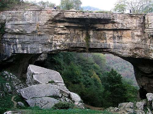
Ponte di Veja
This huge natural bridge at 45.608144, 10.970129, one of the biggest in Europe, is a true landmark of Lessinia. It is located in the community of Sant'Anna d'Alfaedo, on the altitude of 602 m. The 50 m long and 29 m high stone bridge is what was left over when a big karst cave collapsed. In the nearby caves archeologists found also traces of paleolithic men. They can be seen in Museo Paleontologico e Preistorico di Sant'Anna d'Alfaedo. The whole area is nicely arranged for tourist visit and can be reached by a short walk.

Parco delle Cascate di Molina
Below the small village of Molina, at 45.609109, 10.915430, you can start a nice path which leads you through the picturesque gorges of Molina creek. In addition to the gorges, waterfalls and nature in general, also the architecture of small hamlets and moulins is very nice.
 Covolo di Camposilvano
Camposilvano di Velo Veronese
Near Camposilvano there are a many karst phaenomena. The area is known also by rich foundings of fossiles. They are collected in Museo dei Fossili di Camposilvano. Close by (behind the museum house) is the path into a huge sinkhole, called Covolo di Camposilvano (at: 45.626567, 11.092788). The collapsed cave is some 7o m wide and its walls are up to 35 m high. The path into it is easy, but below, just before entering the underground part of the cave, the trail is closed for public access. A really impressive place!
 Valle delle Sfingi
A bit north of Camposilvano, you can deter from the main road eastwards, and you reach at 45.631526, 11.096268, a small farm in the Valley of Sphynxes (Valle delle Sfingi). These are interesting rock formations, otherwise abundant in the upper parts of Lessinia. They look like big bee hives or rock mushrooms.
 Madonna della Lobbia
Madonna della Lobbia
The small statue of Virgin Mary, holding Jesus is the famous Pietà of Lessinia. It stands simply in the middle of picturesque pastures, at 45.649750, 11.144335. This extraordinary, but simple piece of art immediately after its discovery became a symbol of Lessinia. An unknown author created it some 200 years ago. Supposedly it's an unfinished work, but also as such this only 112 cm high statue is most impressive. I guess it was even more impressive in its archaic outlook, before it was cleaned. Now (2015) it stands all white on the pasture. It can be reached by a short walk (or biking) from Campofontana through the settlement of Pagani.
 Giazza/Ljetzan
Giazza/Ljetzan
This small town in Val d'Illasi is nice to visit, but would not exceed other nice villages and towns if it was not a center of small German speaking community which survived in these mountains. These are the Cimbri people, who supposedly settled in those remote places in the 12th century, coming from Bavaria (or even from further north). Nowadays they make all efforts to preserve their language and culture.
 The canyon near Rivoli Veronese
The Adige canyon
On the very SW end, between the Lessinia and Monte Rocca, 265 m, the river of Adige cut a short, yet quite picturesque canyon. In the past several strong fortresses were quarding the strategic passage. Forte Wohlgemuth, near Rivoli Veronese is especially picturesque, today hosting a museum. And indeed, in the times of napoleonic wars near Rivoli Veronese in a big battle French forces defeated the Austrian army.
Mountain Huts
In addition to several huts, serving tourists, in the area you can find also many huts on alpine pastures, where you may get perahps also food and drink. You can visit all sumits in distinct one day tours, so sleeping on mountains is really not needed. On the other hand the are is so charming that you can easily decide to stay there many days.
Red Tape
The central area is from 1990 proclaimed as Parco Regionale della Lessinia. To visit some of tourist landmarks, you need to pay a smal fee, others are free of charge. Many narrow mountain roads in higher region are closed for public traffic, but those which are open, are free of charge.