![On the ridgeline]() Dennis working the top of the ridgeline
Dennis working the top of the ridgeline![Yours truly on Mormon Peak]() Yours truly at the summit
Yours truly at the summitThe centerpiece of our week
![The Railroad Underpass]() The underpass The underpass | ![Water crossing]() The creek The creek | ![Driving in]() The drive in The drive in |
Remote and lonely? It isn't that far from a major interstate but getting to the peak's base is what sets this one apart from many other Nevada peaks that could definitely be called remote. We realized how lonely it was when we discovered we were the first people to visit this peak in almost a year. That is mainly due to difficulty of access (a locked gate that isn't posted for no trespassing).
Fellow SP member
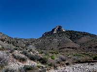
Dennis Poulin and I had already been to the summits of four Nevada mountains on this trip but the one we really really wanted was Mormon Peak, a not so lofty mountain of 7414 feet but significant in the fact that it has over 4000' of prominence, putting it as the 139th most prominent peak in the continental USA.
Operating out of Mesquite Nevada for a few days, we decided that Mormon Peak had to be our target and that we would need to get after it on the first available date just in case we needed an extra day or two to get the job done. We had researched the information available on this mountain and we knew that the biggest problem was getting past a gate that was often locked and a creek that the road had to cross.
Getting an early start, we solved both the gate and creek problems and soon found our way heading up the proper jeep roads. We had GPS waypoints which were very helpful in finding the correct turns and to me that always gives me a nice feeling of security. The road became very rocky and rough in places once we left the main road and the closer we got to the mountain, the rougher and rockier the road became. We were doing this one in Dennis's new truck and several places put those "racing" stripes on the paint job as the brush closed in at a few places. This area is truly remote since we knew from what others had said in their reports that few people get out this way. The area had been designated a
wilderness area by congress in 2004 and that affects the roads that get close to the mountains. Once you hit the
wilderness boundary, you can't drive any further. The road that people used to take to get to the 5000 foot level was no longer feasible and the road was badly washed out above the 4500' level anyway. Many people park at around the 3900 foot level although in our case, we were able to get to
about the 4400' level before we were stopped by the road being washed out.
My GPS indicated that 36.9437 114.5264 was far enough. Others might not want to try and get as far as we did and look for a spot near the 3900-4000 foot level before hitting some rough spots that we were able to get past until totally stopped by washouts.
![Desert flora]() Flora Flora | ![The old road]() The old road The old road | ![Mormon Peak]() The canyon The canyon |
After we parked, got our boots and packs on, we were off. We followed the old road past the washouts and within a 1/3 of a mile, a wilderness boundary marker (which would have stopped us if the washouts hadn't) and made our way over a mile or so to the mouth of the canyon we intended to utilize. No trail marked the way so we found our own path through the brush and the cactus plants. Sometimes we hiked in the wash itself and other times we traversed above it on the hillside. We followed whatever worked best and sometimes the choices were equally poor. Eventually when we got to around the 5400 foot level, we started making our way up toward the ridgeline on the left side of the canyon. Getting to that ridgeline was the key for us and staying on the ridgeline worked best. On the way up, we got off to the north side and soon found our selves working our way up class 3 stuff which worked out OK but on the way down, we avoided that by sticking relentlessly with the ridge itself.
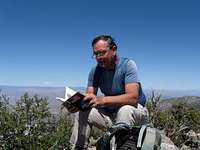
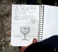
When we ran out of ridge, our GPS's were pointing almost directly east and that was where our peak was. Up a bump and then down on its other side and beyond, and voila, there was the summit with a cairn and my friend Dennis already there. In the center of the cairn was a register container, an ammo can with DPS marked on the side. Inside was a register book which we opened and checked out, noting some familiar names but also realizing that for a DPS peak, this one didn't get all that much action. When we signed in, it had been almost a year to the day that the last party had been here. The gate which is often locked plus the sheer isolation of the place obviously
makes a difference.
![Heading in]() Cross country Cross country | ![Up out of the canyon]() Up & Out Up & Out | ![Heading for the ridgeline]() To the ridgeline To the ridgeline |
We had our lunch and Dennis called his wife to let her know we had made it. Then he allowed me to call my wife since I had no cell coverage (thanks AT &T) and I checked in with her. We took the usual pictures and made ready to make our way back down the way we came. We felt it best to not try a shortcut and felt best to go the same way we had come up, which we did and we even improved on that route by not repeating the class three sections by sticking to the ridge as we had intended to do on the ascent.
Once back at the truck, we bumped and jolted our way back to civilization. We once again resolved the crossing of the creek (no problem) and then the mystery of the gate. When we finally hit pavement again, it really felt good. Even better was the thought of a spaghetti dinner, waiting for us in Mesquite.
![Summit register container]() Register container Register container | ![Mormon Peak Benchmark (NV)]() Benchmark Benchmark | ![Interesting stuff]() Reading the register Reading the register |
Post trip:
We went on to pick up a couple peaks in Utah the next day, and then get another Nevada peak that we really wanted, a 10 mile effort on one called Virgin Peak and then an Arizona peak near Mesquite called Bangs Peak. All in all, we got 9 peaks (see list below) in 10 days before our vacation fun ran out. Can't wait to get back and do some more peaks in Nevada. Thanks to Dennis for partnering up with me and to his wife for being the best camp hostess ever.
She cooked up some great meals and the strawberry shortcake was sublime.
Summit views and summit things
![Looking Southeast]() Looking SE
Looking SE
![Looking north]() Looking north Looking north | ![Looking West]() Looking West Looking West | ![Looking south]() Looking South Looking South |
![Looking eastward]() Looking East
Looking EastThe route
The route we chose was not quite 8 miles round trip with a bit more than 3000 feet of elevation gain. The drive in was long and tedious and the gate was closed (we found a way to deal with that) and the creek crossing was a non factor for our high clearance 4WD truck. The last 5 or 6 miles of road was very rough and rocky and Dennis' new truck received some unwanted racing stripes.
![Route page]() On top of the ridge
On top of the ridgeHard to get mountain
The Las Vegas Mountaineering club dropped Mormon Peak off of its top 50 peaks in 2008 due to the problem members were having with accessibility. I feel sad that such a great and special area is now so hard to get to. It would be worth the effort to lobby the powers who be to rectify this gate situation.
![Last LVMC trip?]() LVMC group in register
LVMC group in registerA week of hiking and climbing in warm weather
Apr 24:
Chokecherry Mtn (it snowed on us)
Apr 25:
Badger Mtn
Apr 26:
Mount Irish
Apr 27:
So. Pahroc Peak
Apr 29: Mormon Peak
Apr 30:
Scrub Peak &
West Mtn Peak (both in Utah)
May 1:
Virgin Peak
May 3:
Bangs Peak (Az)


Comments
Post a Comment