
-
 12447 Hits
-
 85.87% Score
-
 21 Votes
|
|
Mountain/Rock |
|---|---|
|
|
37.22480°N / 118.663°W |
|
|
Inyo |
|
|
Hiking, Mountaineering, Scrambling, Skiing |
|
|
Spring, Summer, Fall, Winter |
|
|
12691 ft / 3868 m |
|
|
Overview
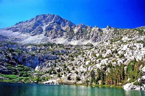
Mount George Davis from Wonder Lakes
"Mount George Davis," is unnamed on topo maps and officially called "Peak 12691." Also sometimes called "Wonder Mountain," "Mount George Davis," "Mount Thoreau," or "Wonder Woman Peak," it is the high point on the massif that rises between the north fork of Bishop Creek and Wonder Lakes in the John Muir Wilderness. This is a typical granite uplift with a sandy plateau slope leading to a steep class 2 talus jumble. It's the peak on the south side of the Piute Pass Trail across from Mount Emerson.
North from the summit is the high pristine desolation of Humphreys Basin with Mount Humphreys to the right. To the east over the confluence of the Bishop Creek drainage and the Owens Valley are the White Mountains and to the south is the Sierra Crest from Mount Thompson on down to the Inconsolable Range and The Palisades. Mount Lamarck and the Sierra crest is above to the west.
The south slope is class 2 from Wonder Lakes. The northwest slope is class 2 from Emerson Lake and the northeast face looks to have some class 3 chutes from the Piute Pass Trail leading up from Loch Leven.
Getting There
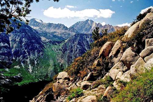
Mount George Davis and Mt. Emerson from the south
From Hwy. 395 in Bishop go west on Hwy 168 (W. Line Road) 17 miles and turn right on North Lake Road. This road winds 2 miles up past North Lake to the North Lake Campground at roads end. Here there is parking for backpackers. Dayhike parking is about a half mile before roads end.
From Wonder Lakes: Class 2, The Lamarck Lake Trailhead (9,400') is at the campground next to the Piute Pass Trail. Cross the creek (bridge) and climb south up the forested switchbacks 1 mile to a junction. Go right another mile up to Lower Lamarck Lake. Break trail and hike (lots of boulders along this shore to negotiate) around the north side of the lake approximately 1 mile to the 3rd of the Wonder Lakes. Scramble the south slope of Mount George Davis to a sandy plateau. Go west to the class 2 summit rocks.
From Emerson Lake: Class 2, Take the Piute Pass Trail approximately 2.7 miles (past Loch Leven). Cross the North Fork of Bishop Creek (this could be a challenge with high runoff). Climb south .3 miles up to Emerson Lake and scramble the northwest slope to the sandy plateau west of the summit. Go east to the summit rocks.
From Loch Leven: Class 3, Take the Piute Pass Trail 2.5 miles to the northwest end of Lock Leven. Cross the creek and climb the northeast face to the plateau. Go right to the summit. Sections of this route could turn out to be class 4 but my guess is once you're on it the chutes that go should be obvious. Check out the snow-filled gullies in the pic below from Emerson.
Red Tape
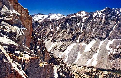
Mount George Davis' northeast face from Mt. Emerson south slope
This peak can be done as a day hike with no restrictions or permits required.
For overnight camping and a comprehensive rundown on rules and regulations go to the John Muir Wilderness page.
Camping
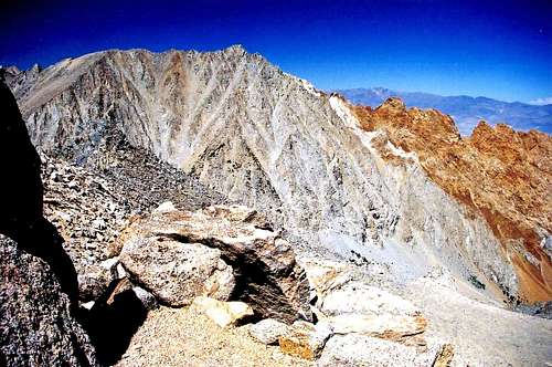
Mt. Emerson and the colorful Piute Crags from Mount George Davis
The nearest campground is the North Lake Campground (9.300') at the end of the North Lane Road next to the trailhead to Piute Pass.
There are several campgrounds along Hwy. 168 leading up to Lake Sabrina:
Forks Campground: 7,800', at the fork junction of Hwy. 168 and the South Lake Road.
Bishop Park area: 8,200', several campgrounds about a mile past the South Lake Road junction on Hwy. 168.
Sabrina Campground: 9,000', .7 miles before Lake Sabrina on Hwy. 168.
There are also several campgrounds along the South Lake Road past the junction with Hwy. 168 on the way to South Lake.
Current weather and 5 day forecast
For current weather and 5-day forecast click here.