
-
 13549 Hits
-
 0% Score
-
 0 Votes
|
|
Trip Report |
|---|---|
|
|
41.40940°N / 122.1939°W |
|
|
Jun 4, 2005 |
|
|
Mountaineering, Skiing |
|
|
Spring |
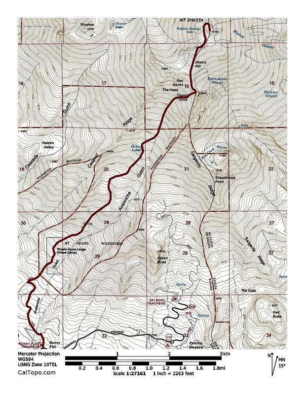
Access from Mount Shasta City, California:
Take Lake Road East.
Lake Road becomes Everitt Memorial Highway.
Take Everitt Memorial Highway to Bunny Flat trailhead (6940').
Mount Shasta:
I hiked up to Avalanche Gulch and climbed it, summiting Misery Hill en route. I never took out my ice axe. The slope never seemed to exceed 40 degrees. I continued hiking to ~100 feet from the summit, dropped my skis due to lack of consistent snow, summited and skied down to the trailhead. From where I started skiing to the top of Avalanche Gulch, the snow was too firm, but never softens up according to a Mount Shasta ranger. Once inside the Gulch, the snow was great. I just had to avoid the glissade tracks. A 35-40 degree slope is maintained for about 3000 vertical feet. The snow never got too heavy even down at the trailhead.
Avalanche Conditions:
Spring conditions; saw old loose avalanches.
Total Elevation: ~7300'
Total Skied Elevation: ~7200'
![Mounts Shasta]()
Map
Take Lake Road East.
Lake Road becomes Everitt Memorial Highway.
Take Everitt Memorial Highway to Bunny Flat trailhead (6940').
Mount Shasta:
I hiked up to Avalanche Gulch and climbed it, summiting Misery Hill en route. I never took out my ice axe. The slope never seemed to exceed 40 degrees. I continued hiking to ~100 feet from the summit, dropped my skis due to lack of consistent snow, summited and skied down to the trailhead. From where I started skiing to the top of Avalanche Gulch, the snow was too firm, but never softens up according to a Mount Shasta ranger. Once inside the Gulch, the snow was great. I just had to avoid the glissade tracks. A 35-40 degree slope is maintained for about 3000 vertical feet. The snow never got too heavy even down at the trailhead.
Avalanche Conditions:
Spring conditions; saw old loose avalanches.
Total Elevation: ~7300'
Total Skied Elevation: ~7200'
Map


Comments
Post a Comment