
|
|
Mountain/Rock |
|---|---|
|
|
39.38213°N / 119.93575°W |
|
|
Washoe |
|
|
Spring, Summer, Fall |
|
|
10243 ft / 3122 m |
|
|
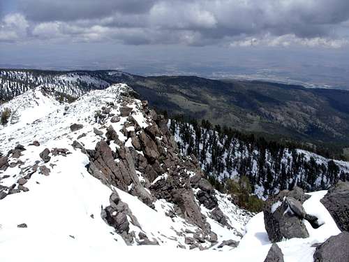
The summit block of Snowflower Mountain - June 7, 2009
Overview
Snowflower Mountain is a gorgeous, rocky-topped mountain in the Lake Tahoe Basin. It is overshadowed by its higher neighbor, Mount Rose, and is climbed far less often. Unlike Mount Rose, and nearby Slide Mountain, Snowflower Mountain is not visible from downtown Reno, Nevada. In fact, in most of Reno, views towards Snowflower Mountain are blocked by the northern ridge of the Carson Range. The Thomas Creek Trail is the primary route up the mountain. It does not go all the way to the summit, but it does top out 550 feet and 3/4 mile from the summit. The mountain can be climbed in about 6 to 7 hours during the summer, faster if trail running part of it.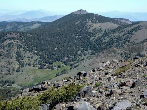
The backside of Snowflower Mountain. One can see the tree covered ridge between it and the Mount Rose massif
Snowflower Mountain is the fifth highest named summit in the Mount Rose Wilderness. Yet, the other four highest are all clustered together. In contrast, Snowflower Mountain stands alone. It is separated from Mount Rose and Church Peak (Mount Rose's north shoulder) by a 2.5 mile ridge.
The best time of year to climb is early summer (June) or in fall (late September through October). The aspen trees change color in fall, which make the hike even more beautiful. Views from the summit are certainly beautiful. Views north, east, and west are spectacular. To the south are views of Mount Rose, Mount Houghton, and Relay Peak. Only a tiny part of the north shore of Lake Tahoe can be seen.
Strangely, the mountain is officially named Snowflower Mountain, but on topographic maps is called Sunflower. It is unclear where the disagreement in its name comes from. However, while there are snowflowers on the mountain, there are no sunflowers. For the purposes of this page, I refer to it as Snowflower Mountain.
Getting There
The most straightforward route to Snowflower Mountain is from the Thomas Creek Trail and FS Road 049. To get there from Reno, take 395 South to the Mount Rose Highway (rt. 431). Once on 431, take it to the west for about 4 1/2 miles until you see Timberline Drive on your right. Turn right on Timberline Drive and then drive uphill for 1.1 miles over a couple bridges. Take a left up Forest Service Road 049, which turns to dirt. Take this moderately rough road for 2.5 miles to a closed steel gate. From here, the road continues slightly downhill. You can park on the road, and then hike downhill to the start of the route. Although the road isn't that bad, a high clearance 4WD is recommended.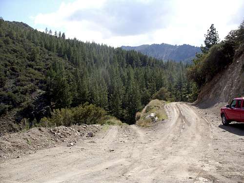
The parking area above the start of the trail
Routes
The route has changed in the last couple years to protect some of the land, and to reroute around private land. This had added nearly 1 and 3/4 miles each way.The route starts at the bottom of the hill below the closed steel gate. The elevation here is about 6950 feet. The road heads uphill, and crosses the Thomas Creek. It continues up to a trail sign. Once at the trail sign, the road has a barrier that says "Road Closed to Motor Vehicle Traffic". Hikers used to head past the barrier and continue up the road, but this road is now littered with "Private Property" signs indicating hikers are trespassing. Take the trail instead. It is longer, but still leads to the same place. The trail is pretty straightforward. There are some creek crossings. Soon after one of the creek crossing, the trail heads steeply up a meadow, in a northwestern direction. This meadow climbs up to over 9,000 feet. Along the way you will see Mount Rose looking south, along with the top of Snowflower Mountain just peaking above the trees. You will also see a gorgeous rock formation to the south.
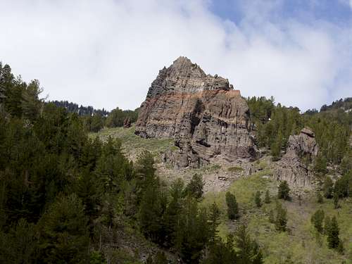
Point 8832, painted rock formation seen along the Thomas Creek Trail.
Once the meadow gets up around 9,000 feet it turns to the south and shortly after heads into the woods. Keep climbing up the trail and you will eventually reach the top of the ridge at just below 9700 feet. You will be in between two rocky summits Point 9896 on your right and Point 9890 on your left. Head left (south) and summit Point 9890. From here you will see the Snowflower Mountain summit block. Skirt down from Point 9890 to an open area in the woods. This obvious open area continues south towards the final summit block. About 1/3rd of a mile from Point 9890, the open slope forks. The right fork heads behind the summit block, and the left fork heads up the summit block. Make sure to head left up the summit block. In just under 1/3rd of a mile you will reach the final summit.
The total round trip distance for this hike is a little over 13 miles with an elevation gain of 3,500 feet.
If hiking from the actual Thomas Creek Trailhead, it is 18 miles round trip, and another 800' or so of elevation gain.
Red Tape
Snowflower Mountain is part of the Mount Rose Wilderness. The trail is on Forest Service land, so there are no restrictions. No permits are required to hike. Just avoid the private land. The private land route only shaves off maybe 3/4 miles each way at the most. Since other parts of the trail have been improved, more switchbacks were also added, thus making the trail even longer.External Links
Lake Tahoe Basin Management UnitWilderness.net