-
 12538 Hits
-
 84.76% Score
-
 21 Votes
|
|
Mountain/Rock |
|---|---|
|
|
38.71225°N / 111.64709°W |
|
|
Sevier |
|
|
Summer |
|
|
11547 ft / 3520 m |
|
|
Overview
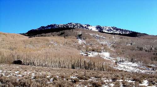
UNDER CONSTRUCTION AS OF July 30, 2012. NEW DIRECTIONS TO BE POSTED SHORTLY. THANK YOU.Mount Terrill - also known as White Knob - is a small, rounded peak north of Seven Mile Valley high on the Fishlake Plateau. Although not much of a technical challenge, this peak is remote and offers incredible views of south-central Utah. On a clear day, points visible from Mount Terrill include Fishlake Hightop, Mytoge, Mount Marvine, Windstorm Peak, Monument Peak, Thousand Lakes Peak, Mount Nebo and Capitol Reef National Park.
The mountain sees few visitors, mostly ATVers, as a worn trail leads to the summit from nearby UM Pass. Heavy snowfall accumulates late October through March. In warmer weather, herds of Elk frequent the mountain slopes, grazing on the short grasses that grow there. Numerous springs feed nearby Lost Creek and Harves River reservoir.
Part of the massive Marysvale Volcanic Field, the peak is covered in 250 to 400 feet of densely welded, vesicle-poor pyroclastic flow deposits overlying Paleocene Flagstaff Limestone. These volcanic deposits were left from an ancient eruption of nearby Monroe Peak Caldera.

Getting There (UNDER CONSTRUCTION)
Note: 4WD is no longer necessary in the summer. The road up Seven Mile Valley is well graded. Cars should have no trouble making it to the jeep trail turnoff. Once on the jeep trail, moderate clearance is required.From Richfield, Utah
From I-70 take exit 119 in Richfield. Follow 119 east through the town of Glenwood and up to the junction with Highway 24. Take 24 south past Koosharem Reservoir until it climbes to meet Highway 25 (toward Fish Lake).
Follow Highway 25 northeast past Fish Lake and Johnson Valley Reservoir. At the northwest corner of Johnson Valley Reservoir is a dirt turn off. A sign proclaims this to be Seven-Mile Valley. Follow this dirt road (NF-319) for about 5 miles. You will pass Mount Marvine on your right. (UNDER CONSTRUCTION AS OF JULY 30, 2012. NEW DIRECTIONS WILL BE POSTED SHORTLY THANK YOU).
From Loa, Utah
Take Highway 24 northwest to its junction with Highway 25 towards Fish Lake. Follow Highway 25 northeast to Johnson Valley Reservoir, the second body of water located just north of Fish Lake. At the northwest corner of Johnson Valley Reservoir is a dirt turn off. A sign proclaims this to be Seven-Mile Valley. Follow this dirt road (NF-319) for about 5 miles. You will pass Mount Marvine on your right.
(UNDER CONSTRUCTION AS OF JULY 30, 2012. NEW DIRECTIONS WILL BE POSTED SHORTLY THANK YOU).

Red Tape
Mount Terrill is located in Fishlake National Forest. No permits are necessary unless you want to cut firewood.
Camping
Camping within the Fish Lake Basin is restricted to designated camping areas, of which there are many. Lodging is available nearby at Bowery Haven Resort and Fish Lake Lodge, located along the northwest shores of the lake.Within Seven Mile Valley, dispersed camping is allowed anywhere on public land, as long as litter is removed and fire/dumping restrictions are followed.

External Links
Fishlake National Forest.Weather forecast for Torrey, Utah. Mount Terrill is cooler by an average of 15 degrees fahrenheit.