

-
 14392 Hits
-
 84.82% Score
-
 19 Votes
|
|
Mountain/Rock |
|---|---|
|
|
43.16850°N / 109.6924°W |
|
|
13020 ft / 3968 m |
|
|
Overview
This remote thirteener, in the northern Wind River Range of Wyoming, gets its name from a snow dome that occurs on its summit. It is a highly recognizable peak and is occasionally mistaken for the similar-looking and nearby Gannett. It is located on the northern end of the U-shaped Peak Lake cirque, one mile west of Split Mountain. Its north face shelters Baby Glacier (which is actually quite sizable) and a hanging glacier which spreads to Stone Pillar pass (which is more of a high saddle than an actual pass); below this is a drainage containing several large, unnamed lakes. Whitecap's southern routes are easily approached from Peak or Stonehammer lakes. The northern side is more difficult to reach but has seen ski-mountaineering activity early late in the spring (May/June).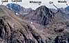 |  |  | 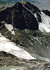 |
Approaches
Peak Lake and Vista Pass are usually reached from the trailhead at Green River Lakes. From Pinedale, follow highway 191 NW for 6 miles to the Cora road. Follow for 45 miles to the lakes.The Highline trail is followed for 15 miles to the Glacier Trail which is followed for 3 miles (through a Class 2 section) to Peak Lake. Peak Lake can also be reached from trailheads to the SW. The trail around the north shore of Peak Lake has been buried by rockslide. Approaches normally take backpackers 2-3 days.Regulations and Specifics
Managed by the Bridger Wilderness and National Forest. Wilderness regulations apply for camp locations, group size, campfire restrictions and ethics. Backpacking stoves and water filtration are necessary. There are no permit requirements. A fee-based campground exists at the trailhead. There are bear requirements for food storage. This area is Grizzly habitat, precautions must be taken.Seasonal Conditions
Summer season in the Wind Rivers is generally July-September with snow lingering on the higher trails into July. A snow storm is traditional between the last week of August and the second week of September. This is often followed by a dry period with crisp temperatures for 1-4 weeks. On glacier routes crevasses are hidden in June and begin opening sometime in July. Roads are usually opened in early June. The peak is visible in an area webcam. The approach is often heavy with mosquitos and gnats June thru August necessitating liberal bug doping.Guides & Outfitters
Whitecap is guided by Exum and Jackson Hole Mountain Guides.Local outfitters are eager to support trips into this area by providing equipment and supply drops as well as horsepacking.
History & Etymology
The 1906 survey of the region applied the traditional lettering/numbering assignment system used by surveyors when facing a multitude of unnamed, sightable peaks. (A system still in place most famously on K2 but also in other spots in the Rockies). The summits surrounding Peak Lake were given the letter G followed by a number from north to south as viewed from Doubletop Mountain (WR) to the west. This peak was given the moniker G-2 (G-1 is now Ladd Peak; G-3 is peak 11925). It was first climbed in 1930 by the legendary Harvard mathematician-climbers Robert Underhill (first ascender of many peaks and importer of technical climbing to America) and Kenneth Henderson during one of their systematic expeditions to the Rockies. They gave it the utilitarian name "Mount Whitecap" due to its appearance from the north. In the summer of 1967, during surveys for the 7.5' Gannett quadrangle, this summit was one of the few chosen for safe visitation via helicopter. The USGS built a large summit cairn, measurements were taken and the name "Whitecap" was beacme official. Since then, the snowpatch has apparently become more seasonal and the cairn has either fallen over or been dismantled. Even when snowless (in late summer) the summit retains a whitish patch.Whitecap is tied with Bow Mountain as the 32nd highest in the state and the 29th in the range. Curiously, Bow, also part of the Peak Lake cirque, is just 2 miles to the south. Neighboring Ladd Peak, whose NW ridge rises 4,700' above Three Forks park, is the single largest-gaining feature in the range.