
|
|
Mountain/Rock |
|---|---|
|
|
46.62238°N / 11.96031°E |
|
|
Trentino Alto-Adige |
|
|
Mountaineering, Trad Climbing, Scrambling, Via Ferrata |
|
|
Summer |
|
|
9928 ft / 3026 m |
|
|
Overview
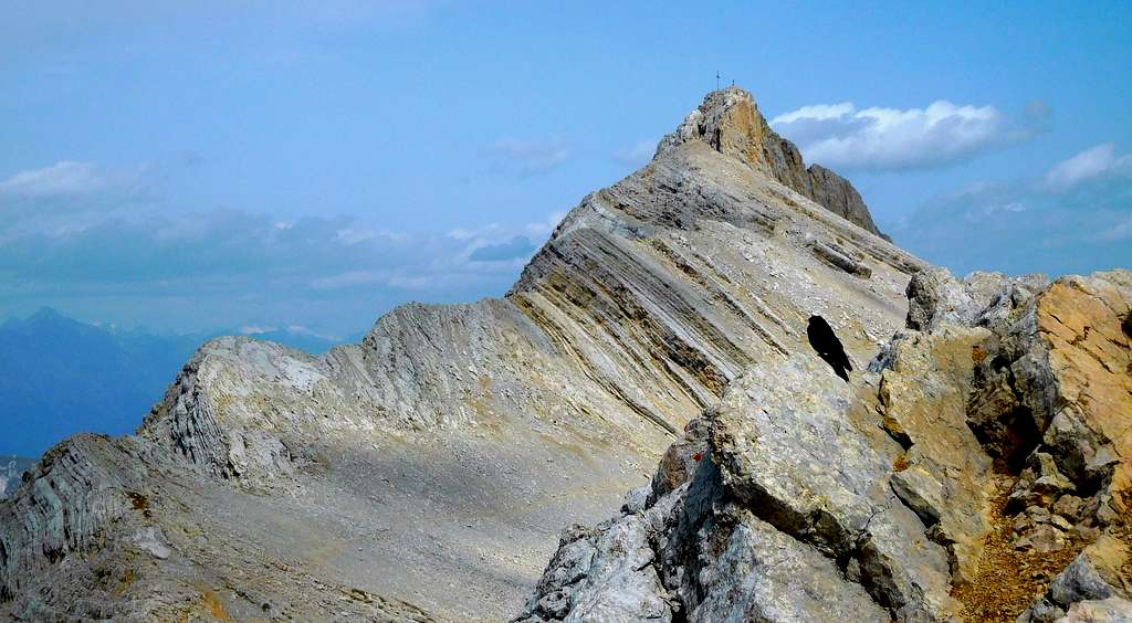
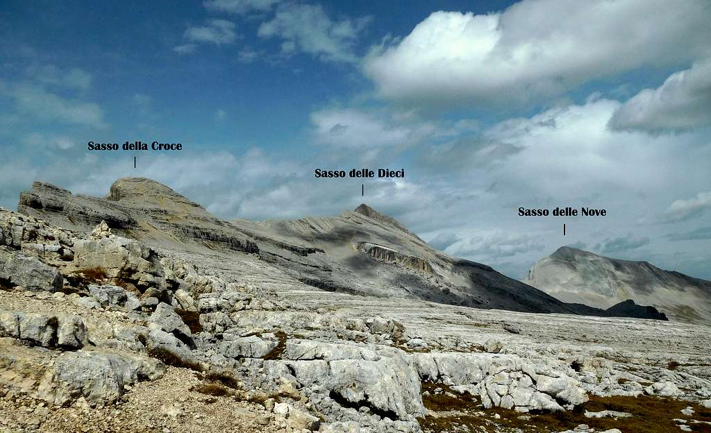
Sasso delle Dieci - Sass dales Diesc m 3026
Not to be confused with the namesake peak situated in the Sella group, Sasso delle Dieci 3026 m - Sass dales Diesc in ladin, Zehnerspitze in German - dominates the Val Badia and therefore it's an outstanding panoramic point from which it's possible to catch a 360 degree view of the Dolomites, as well as the Alpi Aurine. Belonging to the Fanis Group, Cunturines subgroup, it's the main summit on the Sasso della Croce long ridge and the only one in this group overcoming the 3,000 meters over sea level.
There are two itineraries, joining at Forcella della Croce 2612 m, which are frequently climbed to get the summit of the mountain, having both the same difference in level (1000 m). Anyhow the route starting from the Val Badia side (West) is more challenging, because of its first part follows the Via Ferrata crossing the Sass dla Crusc slopes, an itinerary not difficult but a bit impressive. During the uphill it is advisable to climb also the summit of Sass dla Crusc 2907 m., which involves only a brief digression from the itinerary to Sasso delle Dieci.

Getting there

Road access to Pedraces (Val Badia)
- From Bolzano: take the Brennero Motorway A22 towards North, exit Ponte Gardena and then follow the road SS242 up the Val Gardena to Passo Gardena and from here drive down to Corvara. In Corvara follow on the left the signpost to La Villa, then Pedraces-Badia. In the middle of Pedraces take on the right the road to the chairlift station rising to the refuge and church Santa Croce, from where the path leads off to the base of the routes.
- From Passo del Brennero (Brennerpass): follow the Brennero Motorway A22 towards South, exit to Bressanone and then follow the road SS 49 (E66) up the Val Pusteria, getting to San Lorenzo, a few km. before Brunico. Here leave the main road SS 49 and take the road SS 244 up the Val Badia to Pedràces.
- From Venezia-Mestre-Treviso follow the A27 Motorway, exit Belluno, then take the road SS51 to Cortina d'Ampezzo, Passo Falzarego, Passo Valparola and San Cassiano, La Villa, Pedraces.
In Pedraces leave the main road and take the road leading in about 400 meters to the Santa Croce chairlift station (in two trunks) rising to Santa Croce Hospiz. Alternatively from S. Leonardo in Badia it's possible to climb by foot in about 1.30 hours along the path 7.
Road access to Pederü (Val Marebbe)
Once on the road SS244 (main Val Badia road) in Longega leave the main road and turn to left to San Vigilio Val Marebbe. Follow the road until it ends in Pederü 1545 m. From Pederü take the path to Alpe Pices Fanes, leading to Rifugi Fanes or Lavarela 2040 (2 hours). Jeeps service available.
Normal Route from Ospizio Santa Croce

Sasso delle Dieci Normal Route from Ospizio Santa Croce
Summit: m. 3026
Difficulty: Alpine F+
Exposure: West, then South
Difference in level: 1000 m. from Ospizio Santa Croce
Starting point: Ospizio Santa Croce 2045 m

This route starting from the Santa Croce Hospiz and following at first the Ferrata del Monte Cavallo is the most spectacular way to climb up the summit of Sasso delle Dieci, but not the easiest one. By walking - or by the Santa Croce chair-lift starting from Pedràces - reach the Ospizio Santa Croce m. 2046, a marvellous place located below the stunning West walls of Sass dla Crusc. From the Hospice of Santa Croce take the path n. 7 which, to the right, leads under the walls of the Sasso della Croce. After crossing the slopes covered by dwarf pines, the trail crosses a couple of scree gullies and reaches the base of the giant rocky walls of Sasso della Croce.


Here the route begins to climb - always rightwards - in the direction of the vertical and yellow walls, following easy steps and a system of gullies and legs (some sections are equipped with metallic rope). Once the route reachs the wide scree slope at mid-height, it continues with a long rightwards traverse, crossing the rocky socket with passages on legs, gullies and brief walls and with a last equipped stretch exits to the broad Forcella della Croce 2612 (Ju dla Santa Crusc), overlooking the rocky karst plateau of Pices Fanes, where it opens a spectacular panorama over the Eastern Dolomites. This saddle can be approached also starting from the Lavarella and Fanes shelters, with a much less challenging itinerary (descripted in the next chapter). From the Forcella della Croce (signposts) follow the path to the left, which runs through the ridge of the Sasso della Croce (cairns and red-white marks, taking impressive views of the walls dropping down towards the Val Badia. At a crossroads just a hundred of meters below the summit of Sasso della Croce, if you climb to the left, after a few bends, you can reach the summit of the Sasso Cavallo 2907 m (huge cross and summit book). Back at the fork (20 minutes up and own), take the right path to the visible peak of the Sasso delle Dieci. At first the route follow a mainly flat path then, lastly, a steep climb on the scree slope leads to the base of the short but steep SW rocky ridge. Climb up the airy wall (30 m, iron cables), then with a brief traverse you can easily get the big summit cross (summit book). The views are gorgeous!


Descent: reversing the same route
Normal Route from Alpe Pices Fanes


Sasso delle Dieci Normal Route from Alpe di Pices Fanes
Summit: m. 3026
Difficulty: Alpine F+
Difference in level: 1000 m
Starting point: Rifugi Fanes or Lavarela
From the shelters take the path n. 12; once reaching the karst tableland take on the right the path n. 7 rising to the broad Forcella della Croce 2609 m (2 hours from Fanes). From here follow the route as described in the previous chapter.
Descent: reversing the same route
Red Tape
No fees no permits required
Natural parks

Together with the adjacent mountains, Sasso delle Dieci is located in the Fanes - Sennes - Braies Nature Park established in the year 1980. With an area of 25,680 hectares is one of the largest parks in the province of Bolzano Alto Adige. The park borders the North with the val Pusteria, to the West with the Val Badia to the south with the Val Travenanzes and to the east with the Val di Landro. These park is located inside the Dolomiti Settentrionali – Northern Dolomites, one of the nine areas of the Dolomites acknowledged as Dolomites acknowledged as UNESCO World Heritage Site.
More info on SP: Dolomites, living mountains.
When to Climb
The best months are June, July, August and September
Where to stay

Several possibilities in Val Badia and Val Marebbe (hotels, bed and breakfast, camping)
Huts on the West side: Rifugio Santa Croce
Huts on the East side: Rifugio Fanes - Rifugio Lavarella
Bibliography
"3000 delle Dolomiti" - Ed. Idea Montagna, Collana "Vie Normali", 2012
"Alta Badia - Livinallongo" Tabacco 07 1:25000
Meteo Forecast
Meteo Provincia Bolzano Alto Adige