

|
|
Mountain/Rock |
|---|---|
|
|
17.03561°N / 61.86041°W |
|
|
Hiking |
|
|
Spring, Summer, Fall, Winter |
|
|
1319 ft / 402 m |
|
|
Mount Obama once Boggy Peak (The highest point on Antigua)
| “Antigua and Barbuda – Land of Sea and Sun.” HEART of the CARRIBEAN |
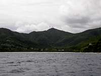
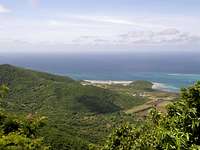
 Boggy Peak now Mount Obama from the Jolly Beach holiday complex.
On the island of Antigua is an area of hills known as the Shekerley Mountains. This small group of hills has the islands highest summit. This was once the oddly named summit of Boggy Peak. The summit is occupied by many different telecom related structures and the summits highest point as in its trig survey point is within one of the large private fenced compound areas owned by the telecoms company Cable and Wireless. The sad thing is that there are no really good views from the summit unless you can get access into this compound.
Boggy peak has now been re-named Mount Obama in memory of president Obama and the area of hills that Mount Obama is in will be transformed into a national park and nature reserve so as to protect the area.
The highest part of the island is the area round the steep hills of these Shekerley Mountains on the south coast and along with Mount Obama there are other summits in this area over 1000 feet. These areas have steep hills of ancient volcanic formation.
The hills here are covered in lush green vegetation which gives the impression of a tropical rain forest. The truth behind it is, the island actually has no forests of any kind on it.
This area also has many steep-sided valleys which in heavy rain hold fast-flowing streams. This again gives a misleading impression as there are no permanent rivers or streams on the complete island.


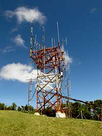
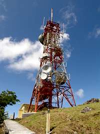
The Radio Towers:-
The main summit of Mount Obama has many different radio telecom related structures crowning it. The large red and white microwave radio relay tower has links to the island of Montserrat. The many other structures support local network cellular operators and VHF radio services.


The Summit Views:-
When standing on the trig survey point marking the summit of this fine hill the views you are presented with are rewarding and if you are lucky to get authorised access into the tower compound like I did you will not be disappointed. The pictures below show how impressive these views are as you can see across most of the island except the area blocked by the neighbouring Shekerley Mountain tops.
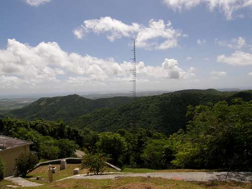 A view looking out across the Shekerley Mountains


Getting There
Buses leave the main town of St. John's from the bus station west of the old Road. All you need to do is ask the driver to be dropped of at the access road at the base of Mount Obama. The fares actually vary depending on where your journey actually starts from but they are not at all expensive at around EC$3.50 (US$ 1.30)Other than buses you can always get a taxi from any point on the island.
Flights from other countries are available to the islands international airport.
V.C. Bird International Airport.
Red Tape
To get access to the very summit of Mount Obama you need to be very lucky in that you need somebody from the crew working for the company Cable & Wireless.The main reason for this is that the exact trig-reference point is actually in the grounds of the many radio towers that crown the summit.
If you are lucky to meet someone when you get up there then the views are fantastic.
There are no guided trips to the summit.
A bit more:-
Bit more about Antigua and Barbuda:-Antigua and Barbuda are two small islands about twenty-seven miles apart in the eastern reaches of the Caribbean. The state does have a third island this being the island of Redonda. This is a much smaller island about thirty miles to the south-west of Antigua. Redonda can be seen clearly from Antigua on most days but is invisible from Barbuda. It is rarely visited by anyone, having been deserted for the past sixty years or so.
Antigua is in the middle of the Leeward Islands which form the most northerly group of the Lesser Antilles. It is about 450 miles to the east of Hispaniola and the same distance to the north of Trinidad. Unlike most of the islands which form the eastern boundary of the Caribbean Sea Antigua consists of very little volcanic origin. Instead it is formed of mainly sedimentary rocks, chiefly limestone, with the remains of very ancient volcanic activity in one corner of the island only. Antigua has an area of about 108 square miles. The island is roughly oval in shape and its coastline is so irregular, with deep bays and creeks, that to compare the island with any regular shape would end up stretching the human imagination. The islands is said to have 365 different beaches. They say there is one for each day of the year. I don’t know if this comment is true but it seems a common comment made in many tourist related books.
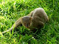 Wild Mongoose
 Butterfly
 Humming Bird
Climate:-
Antigua lies in the path of what are known as the North-East Trade Winds and the island has very little rainfall. A strange little fact I was told is that the wind on the island blows 90% of the time from the east…? Also with the island having little high ground the annual average figure for the rainfall is about 45 inches.
The low rainfall and almost constant easterly breeze give Antigua one of the finest climates in the world.
The island has no such thing as a wet or dry season but the wettest months are normally September, October and November when March and April are normally the driest. The island is normally at its warmest in August, September and October. These months the temperatures can reach 80-89 F 28-32 C. The coolest months are December, January and February where temperatures range from 70-80 F 21-28 C.
The island is at times struck by tropical storms or hurricanes. In fact the complete Caribbean is prone to these storms and has what is known as the hurricane season which normally lasts from mid July through to mid October. August is the month when the island is at serious risk as it is this month when they are most common.
 Tree Lizard
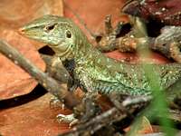 Ground Lizard
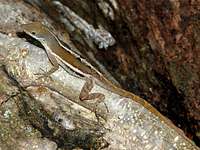 Anole Lizard
Earthquakes:-
Antigua, besides being at risk from hurricanes is also prone to tremors and earthquakes. Most of the tremors that the island has are so minor that a lot of the time they are not even noticed. The last earthquake to course the island some damage was in 1974 coursing damage to various buildings in the town of St John’s. The threats here though are so small in comparison to cities such as San Francisco or even Tokyo, and Antigua having no real densely populated areas or sky scrapers the risk or danger to the population is minimal.
More information is available from the web-link below:-
ANTIGUA-BARBUDA
Accomadation and Camping:-
Details of accomodation hotels and complexes is not easy as if you live on the island it is that small you dont really need any reason to stay out.Obviously if you have come over for your holiday from another country then accomodation and hotels should in most cases have been arranged as part of the holiday.
The other option you have is to carry out a general search on a site such as Google including Antigua and hotels in your search.