-
 14244 Hits
-
 85.36% Score
-
 20 Votes
|
|
Mountain/Rock |
|---|---|
|
|
39.56310°N / 105.8281°W |
|
|
Hiking |
|
|
Summer |
|
|
13134 ft / 4003 m |
|
|
Overview


Sullivan Mountain lies a short distance southeast of Santa Fe Peak in Colorado’s Front Range. At 13,134’ and in an area deeply marked by mine ruins and roads, Sullivan, which is also a short, easy climb, is probably on few people’s lists of must-do peaks in Colorado. But almost every mountain has its charms and few deserve to be overlooked, and Sullivan is no exception.
Some reasons to climb Sullivan other than the fact that it is there:
• It is on the Continental Divide, standing atop which holds a mysterious allure for many people, myself included.
• It is along the way to its higher and more interesting neighbor Geneva Peak.
• It is part of a spectacular ridge traverse between Webster Pass and Santa Fe Peak, covering about 5 miles one-way and crossing 5 summits, 3 of them named.
• Lots of open tundra, wildflowers, and dramatic mountain scenery at a very reasonable price.
• Solitude in a mountain range that often direly lacks it.
• You drove up Santa Fe Peak and feel a little guilty about such an effortless ascent of a mountain.
If you’re more into the spirit of the mountains and mountaineering than you are into the trophy peaks, head for Sullivan. Up there, smile in the knowing that as you look upon the summits of the very popular and often-crowded fourteeners Grays and Torreys Peaks, Mount Evans, and Mount Bierstadt, you are all alone. You’re seeing everything that’s great about Colorado’s Front Range without seeing, and hearing, everything that’s not.
Let me be clear: Sullivan itself is a joke of a "climb" from Santa Fe Peak and will take a lot of people less than an hour RT to do. I strongly recommend making Sullivan part of a longer traverse that involves Geneva Peak (see link above) and Landslide Peak and perhaps one or both of the unnamed summits beyond them but before Webster Pass. Otherwise, look at it as something nice to take the kids to.
It is easiest to climb Sullivan using a 4WD vehicle for the approach. Some details about the access road:
• The road to Santa Fe Peak is marked as a 4WD road for good reasons. It is very steep in places (climbing to over 13,000’), with tight switchbacks and some off-camber spots. I have made it up the road in 4-High before, but it is more comforting to use 4-Low in some places. Although the road is rocky in places, it is not too rugged for stock high-clearance vehicles. I do recommend using a vehicle with real 4WD, but skilled off-road drivers could probably make it up the road with just AWD.
Route Information
I mentioned that climbing Sullivan is short and easy, but there’s a catch; you need 4WD and have to know how to use it (see Getting There plus road details above).
Park a little southeast of Santa Fe Peak’s summit and start hiking southeast to Sullivan. Unless you took the road too far and went too low and far from the peak, you will have to lose a little elevation before reaching the saddle between Santa Fe and Sullivan. From the saddle, climb about 275 vertical feet on tundra and rock (try to stay on rock as much as possible to avoid damaging the tundra, which can take centuries to recover) to the summit. The lack of 300’ of prominence from that connecting saddle could technically disqualify Sullivan from being a named mountain, but it does have its name and place on maps regardless (like some better-known Colorado peaks such as North Maroon, El Diente, and Cameron). But because of that prominence issue, it is an unranked peak.
The round-trip hike is only about 1 mile (Class 2), so consider a longer outing by continuing on to Geneva Peak and maybe Landslide Peak as well, which ups the RT distance to 4 miles and makes for a total elevation gain of about 2000’. If you choose to hike up the Santa Fe Peak Road rather than drive it, the RT distance just for Sullivan will be up to 11 miles, with an elevation gain of over 3000’.
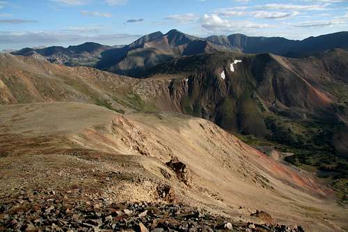
 A great view-- one of many
Getting There
From U.S. 6 at the eastern end of Keystone, take the signed road to Montezuma. This road is easy to find if one is traveling eastbound, but there is no direct access to it for westbound travelers, who will have to watch for the road and then make a U-turn to get to it.
It is five miles to Montezuma, where the road turns to dirt. The road to Santa Fe Peak takes off to the left, but it is not signed. Look for a road heading uphill into the wooded slopes above the tiny town, or look for a telephone/power pole marked 5325 and turn left onto the road there.
It is 5.1 miles to where I parked my jeep and began hiking. When the road finally tops a plateau-like area near the base of Santa Fe Peak at about 4.5 miles (the peak is ahead and to your right), there is an intersection. TURN LEFT. The right fork seems to head straight for the peak, but it dead-ends shortly, though far enough away that you can’t see that from the intersection. The left fork eventually turns southeast and heads toward Santa Fe Peak, edging along the right (west) side of the summit. As it edges along the side of the summit, the road is narrow, rough, and, for a vehicle, exposed, and this section may unnerve some drivers. But if you continue on, the road will start descending steeply. Park in a small rocky area just off the left side of the road and about a hundred vertical feet above the saddle connecting the peak to Sullivan (see photo in this section-- right column).
DO NOT PARK ON THE ROAD. No matter where you decide to park, make sure you are off the road (and not on the tundra). This road is too narrow for people to be blocking it even a bit.

Red Tape, Camping, and Links
No red tape.
There are some primitive camping areas along the road to Montezuma. There are very few decent camping areas along the road to Santa Fe Peak, and many of them are either on posted private property or between 12,000 and 13,000 feet in altitude, where it’s not very comfortable for most people to sleep.
Contact White River National Forest for more information, including for the Santa Fe Peak Road. Phone number: 970-945-2521.
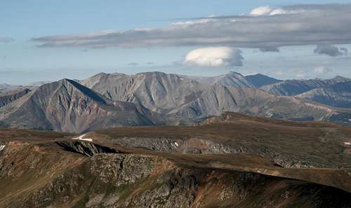
Summit Views