
|
|
Mountain/Rock |
|---|---|
|
|
40.05400°N / 105.646°W |
|
|
13409 ft / 4087 m |
|
|
Navajo Peak Overview
The following photo courtesy of CharlesD
The Indian Peak Wilderness is located just northwest of Boulder Colorado; it's really just an continuation of the existing beautiful mountains of Rocky Mountain National Park. Because of the Indian Peaks proximity to Denver and Boulder, and easy access, this area is probably the most frequently visited wilderness in Colorado. From easy walk-ups to technical 5.5 climbing this mountaineering playground offers something for everybody.
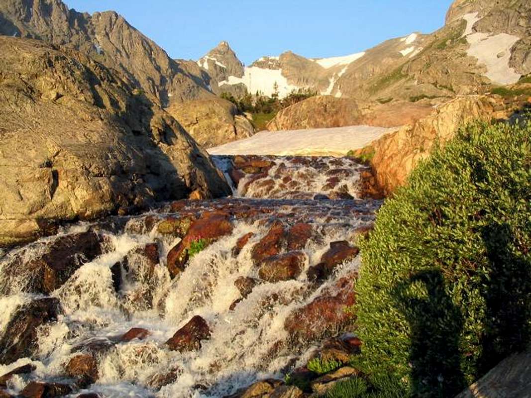
Navajo Peak (13,409 ft.) rests within the Brainard Lake Recreation area with other prominent peaks such as Apache Peak, Shashoni , Paiute, Toll, and Mount Audubon. This picturesque cone-shaped peak is the third highest mountain within the Indian Peak Wilderness boundary. It is a real mountain with a real class 3 rating, and is not for the novice hiker. The summit cone involves some interesting airy moves around its 30 to 40 ft. summit cliff on relatively solid rock.
There are two main trail systems in this area, the Mitchell Lake Trail and the Long Lake Trail, both are well maintained and deliver you to high and wild places. The Long Lake Trailhead (10,500 ft.) is the starting point for a Navajo, Apache, or a Shashoni climb.
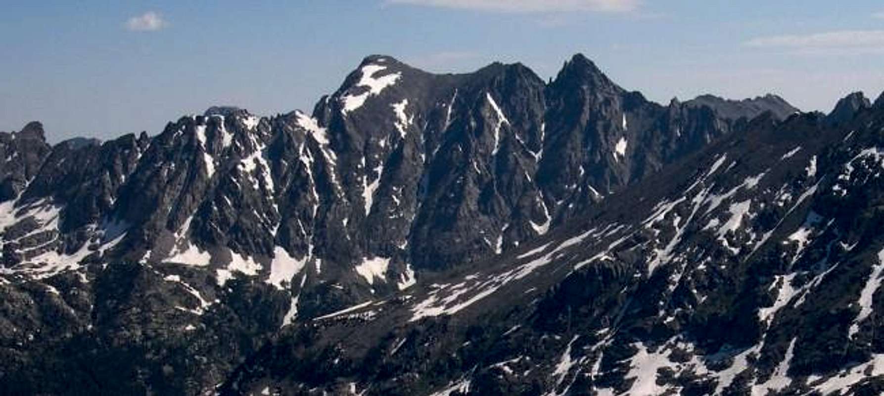
The Apache/Navajo Peak Massif from the west
Apache Peak is the high point on the left and Navajo Peak is the cone-shaped Peak on the right.
Airplane crash on Navajo Peak
The aircraft went down on January 21, 1948. The aircraft was a Civil Aeronautics Administration C-47. The aircraft had left Stapleton Airport was en route to Grand Junction from Denver. The likely cause of the crash was a severe downdraft in bad weather.
On board were :
- Pilot Fred Snavley, of Kansas City, Kansas, aged 39
- Co-pilot Warren L. Lungstrom of Leavenworth, Kansas, aged 28.
- Aircraft inspector Ross C. Brown, age 40 of Denver, Colorado.
Following the crash, an imediate search of the area was posponed by bad weather. The winter of 1948 was harsh, preventing the Ski Patrol and the Rocky Mountain Rescue Unit from locating the plane on their initial three attempts due in large part to deep snow fall. At the time the CAA was offering a $1000 for any information leading to the crash site.
On May 24th, 1948, four months after the C-47 had been confirmed missing, the crash site was eventually located by an air search of the area. The Boulder Daily Camera reported that the aircraft hit a cliff, exploded, rebounded and slid down the mountain in a ball of fire leaving wreckage up and down the mountain. The bodies of the three on board were eventually removed from the airplane debris.
Most of the wreckage is spewn up high in "airplane gully" on Niwot Ridge at 12,900-ft. Some of the debri can also be found at the bottom of the gully as well. Viewing the wreckage requires a somewhat difficult scramble up a gully to get to it.
Because the crash site is a historical aviation archeology site, the wreckage must not be removed. Most of what's left are large pieces of insulation, aluminum chasis and engine parts. - Official Accident report
- Boulder Daily Camera
- Rocky Mountain News
Long Lake TH-Brainard Lake
To reach the Brainard Lake Road from the north follow Colorado 72 or the Peak to Peak Highway, south for 10.2 miles from the junction with highway 7. For the southern approach, go north 12 miles from Colorado 72 in Nederland to the town of Ward, the Brainard Lake Road is just north of here. Turn west on Brainard Lake Road and go 5 miles on paved road to Brainard Lake. Follow the Long Lake Trailhead signs another .5 mile to a large parking area. There is a $9.00 (2009) fee to enter this recreation area.
Red Tape
- A $9.00 fee to enter the Brainard Lake area. The area is closed from October to early June. You can buy a season parking pass.
Here is a summery of the Indian Peak Wilderness Rules and Regulations. - Motorized vehicles are not permitted, including bicycles.
- A permit is required for camping in the wilderness area between June 1 and Sept. 15. Permits are issued for 19 travel zones within the Indian Peak boundaries. Permits are $5.00 at the following offices. For information or to apply for a use permit, contact the U.S. Forest Service, Boulder Ranger District, 2140 Yarmouth Ave., 303-541-2500, or the Sulphur Ranger District, 9 Ten Mile Drive, P.O. Box 10, Granby, CO 80446, 1-970-887-4100. For recorded information, call the Indian Peaks Wilderness Information Line at 303-541-2519.
- Only a certain number of groups are allowed in each travel zone for overnight camping. Camping is limited to two weeks in any four-week period; the two weeks can be in any travel zone.
- Organized groups (maximum size of 12) must have permit for camping or hiking at all times.
- Campsites must be at least 100 yards from lakes and streams.
- Fires are prohibited east of the Continental Divide. Fires are allowed in certain areas west of the divide.
- Dogs must be leashed.
Camping
For a list of every public campground on the Peak to Peak highway, click here
Current Conditions
Click image to enlarge
The Brainard Lake Recreation Area is closed from mid October to mid June every season. It is approximatly a 5 mile drive from the gate closure to the trailheads during this stretch of closure. Usually by early April the snow has melted off the paved road leading to the trailheads. You can easily ride a bike to the TH, many people do.
External Links
- The Ghosts of Airplane Gully
The Perils of High Altitude Flying
At 4:25 PM on January 21, 1948 a two-engine C-47 airplane owned by the Civil Aeronautics Authority set off from Denver’s Stapleton airport on a routine flight to Grand Junction, Colorado, to test aviation radio communication equipment. Carrying a three-man crew, the aircraft faded into the western gray sky headed for what was thought to be unsettled but passable weather.... - Apache Peak & Navajo Peak
- The Ghosts of Airplane Gully
Brian Kalet - Oct 15, 2010 4:23 pm - Voted 10/10
Re: Uhm...Yes, most definitely northWest of Boulder, CO.
Kane - Oct 16, 2010 9:19 pm - Hasn't voted
Re: Uhm...Thanks
meclimber - Aug 17, 2013 10:54 am - Hasn't voted
Airplane wreckageInteresting to learn about the airplane wreckage. I stumbled across a mangled fuselage in a boulderfield on my approach to Apache last October. What I found definitely was not up high in a gully, but relatively far back and down low from any cliff.