
-
 22781 Hits
-
 88.61% Score
-
 27 Votes
|
|
Mountain/Rock |
|---|---|
|
|
48.45330°N / 113.34343°W |
|
|
Glacier |
|
|
Scrambling |
|
|
Spring, Summer, Fall |
|
|
8847 ft / 2697 m |
|
|

|
|---|
| To visit Glacier National Park is to enter a place were Heaven touches earth affording brief glimpses into the Wonders of Creation. |
Overview:
Due to its location Mount Henry played an important role during the days of trail rides in Glacier National Park. In fact prior to World War Two there was a large bell on its summit that hikers could ring. For more information on the trail rides see A Historical Look at Glacier's Horse Trails.Jack Holterman, in Place Names of Glacier National Park, suggests that Mount Henry was named for Alexander Henry, who explored the area between Montreal and Lake Superior to across the plains of Manitoba, Sasketchawan and Alberta to the area near Oregon.
Willard Schultz wrote that Mount Henry was called "Chief Bear" or "Bear Chief" who was around these parts in the 1830s. Bear Chief lead a small party of Blackfeet who reportedly killed 45 Salish as well as 2 French-Canadian. A portrait of Bear Chief was painted by the famous artist Bodmer.
 Mount Henry is covered in snow in the August 13, 2005 photo. It was taken from the Glacier Park Boat Co. vessel on Two Medicine Lake. On the right is Never Laughs Mountain and on the left is Appistoki Peak.
 View from Mt. Henry into the Nyack area, St. Nicholas is seen in the center of this photo
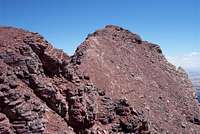 Mount Henry viewed from the west
 Mount Henry from Dancing Lady Mountain, Fred Spicker photo.
Layout designed for best viewing on a "1024 x 768" screen.
An enjoyable day with incredible views into the Nyack and Two Medicine Valleys and a ridge walk to summit three of Glacier's named peaks.
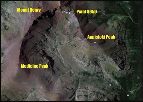
Mount Henry is part of The Scenic Point Ridge Walk and according to J. Gordon Edwards is “a route that covers 13 miles of exhilarating open country.” This route crosses three named Glacier Park Peaks which include Mt. Henry and Appistoki Peak as well as Medicine Mountain.
At an elevation of 8,847 feet Mount Henry is not one of Glacier's more well known peaks but climbing Mount Henry produces rewards such as a unique views and a fantastic ridgewalk through meadows of flowers.
Getting There:
 Views along the route to Mount Henry
Glacier National Park, the crown of the continent, is located in northwestern Montana and shares a border with Waterton International Peace Park in Canada. The Scenic Point Ridge Walk is located in the Two Medicine Valley in the southeastern corner on Glacier National Park.
Driving Instructions From East Glacier, Montana: After reaching East Glacier, Montana on Highway 2 and travel 4 miles North on State Highway 49 to the Two Medicine turnoff. The Scenic Point Trailhead is approximately 8.5 miles from the Highway 49 Junction. The trail to Scenic Point is clearly marked on Glacier Road Map.
Driving Instructions From St. Mary's, Montana: Travel south on Highway 89 to Kiowa Junction, turn right on to Highway 49 and continue 9 miles to the Two Medicine turnoff. The Scenic Point Trailhead is approximately 8.5 miles from the Highway 49 Junction. The trail to Scenic Point is clearly marked on Glacier Road Map.
Go to road information for road conditions, road repairs and delay schedules as well as estimated opening information.
Red Tape:
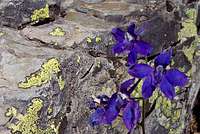 Low Larkspur found in the Two Medicine Valley
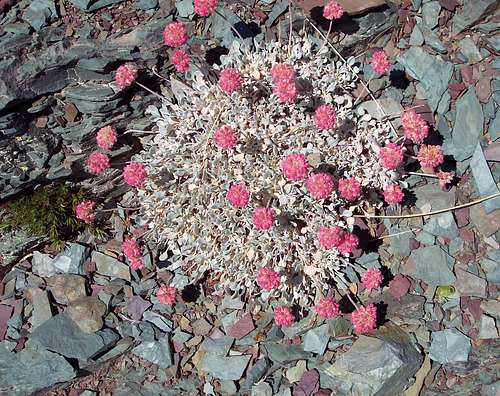 Cushion Buckwheat, Eriogonum ovalifolium
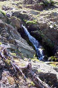 A waterfall on Appistoki Creek below Henry's north face
For current National Park Entrance Fees: Current Park Information
For all the Rules and Regulations governing Glacier National Park look at the Rules and Regulations.
It is not necessary to register for day climbs in Glacier National Park but it is recommended. Backcountry travel regulations can be found at Backcountry Travel. There is also information from the Park Service on Mountain Climbing in Glacier.
As with all hiking and climbing in Glacier National Park use caution and practice good manners with the wildlife. You are in bear country. Carry your bear deterrent spray, don’t hike alone and make some noise. For more information please go to the Park's website for Bear Information. The U.S. Forest Service also has helpful information on Grizzly Bear Management.
Route Information:
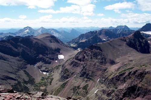
 View of ridge walk from Medicine Peak
Volume Two of Climb Glacier National Park has details on Mount Henry and suggested routes. It can be ordered at Climb Glacier National Park.
Mount Henry and the Scenic Point ridge Walk are featured in Edwards’ “Routes Among The Peaks” on pages 315-316 in A Climber’s Guide to Glacier National Park. Edwards states in his guidebook that the trip should take about 10 hours. It also crosses unnamed peaks and allows access for other peaks in the area such as Mount Ellsworth on an extended ridge walk.
Mount Henry sits at the head of Appistoki Creek and has an imposing face that rises over 1,700 feet above the valley floor.
Total elevation gained from the trailhead is 3,867 feet to the summit of Mt. Henry. To reach the summit of Appistoki Peak it is necessary descend 1,000 feet in elevation before gaining 500 feet again.
There are at least three common options used to reach the summit of Mount Henry.
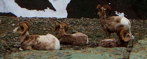 Gentlemen's Only Club
The most common and perhaps most scenic is the Scenic Point Ride Walk. There are two possible ways to reach the summit of Mount Henry. The least technical is Scenic Point Ridge Walk - Gully Route. The second route entails a Class 4 scramble over the arete directly to the east of Mount Henry. This route, the Scenic Point Ridge Walk-Arete Route, is enjoyable and there is some "pleasant" eposure.
The other option The Appistoki Creek Route is to leave the Scenic Point Trail at the switchback above Appistoki Falls and achieve the saddle between Appistoki Peak and the unnamed peak to the west. A good game/climber's trail leads up to the base of the unnamed peak and then east through some enjoyable scree fields and cliffs to the summit of Mount Henry. This route will demand more elevation gain and loss as compared to the Scenic Point Ridge Walk.
When To Climb and Weather:
 A view of additional routes if so desired.
It is possible to complete the Scenic Point Ridge Walk during most months of the year. It would be necessary to ski or snowshoe to this route after the roads close. Roads in the Two Medicine area typically open in the late spring. Click here for Glacier Park Road Status. Alpinists will experience a higher degree of challenge earlier and later in the season. Glacier Park roads close at a moments notice due to poor road conditions and snowfall.
The east side of Glacier Park is notorious for strong winds up to 100 miles per hour being clocked. Winds in East Glacier, Montana just off the continental divide have been strong enough to knock railroad cars off of bridges. Most days in the summer and fall are not that extreme. Check out Glacier Park's what's new page road conditions and the usual happenings at Glacier National Park. For current weather see Glacier Park Weather.
Essential Gear and Camping:
 Scenic Point Ridgewalk
This is a dry route until descending off of Appistoki so take water for the trip. Hiking poles will aide in your ascent and descent while working through Glacier’s wonderful scree! If an early season climb is made an ice axe and crampons may be needed to cross snowfields.
There is a park campground at Two Medicine
Other options for camping include: GNP Campground Information, USFS Campgrounds, Camping on the Blackfeet Reservation or East Glacier Campgrounds
Links:
Glacier National Park in PicturesGlacier Mountaineering Society
Two Medicine Trails
Visit Montana