
|
|
Mountain/Rock |
|---|---|
|
|
40.74936°N / 110.6468°W |
|
|
Summit Duchesne |
|
|
Hiking |
|
|
Summer |
|
|
12545 ft / 3824 m |
|
|

Meadow Peak
Overview
"Meadow Peak" (12545') (prominence 565') is the 43rd highest peak in the state of Utah by the 300' prominence rule. It is located in the Uintas 14.5 miles east of Kings Peak, the state highpoint, on the main east/west Uinta crest. It is seldom climbed as there are only two logged ascents on ListsofJohn. As a contrast, the 43rd highest peak in Colorado (Ellingwood Point) has 345 logged ascents. The Uinta trail system was built for horses and is used primarily to access lakes. Relatively few hikers venture off trail to climb any of the peaks. Utah is not the peak bagging mecca that Colorado is and many of its highest peaks see few ascents. In the Uintas, the few out-of-state climbers go for Kings Peak and maybe the county high points Gilbert and Eccentric, leaving the rest of the peaks above 12000 feet whimpering for attention. The eastern ones are merely rounded bumps, but the ones west of Kings Peak are very rugged and are challenging objectives for the experienced hiker. "Meadow Peak" is ringed with cliffs and loose rock, yet the cliff break god was generous and there is a very convenient wide gully on the eastern side allowing for a relatively easy ascent.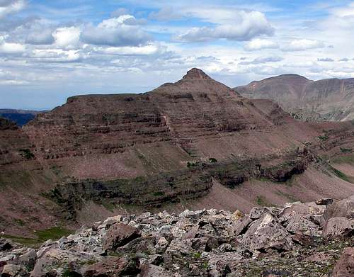
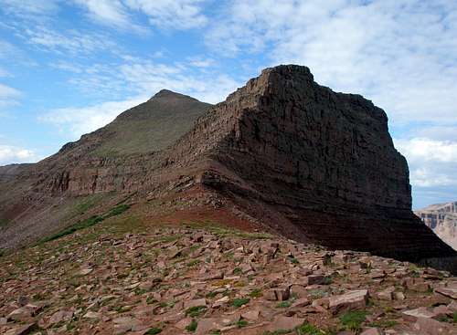
Gully (dark green bottom) starts on right side of picture a little below center
The Uintas are beautiful and many peaks are colored red or gold. Depending upon time of day and angle viewed, "Meadow Peak" can look either red or gold, but usually it appears reddish.

The red "Meadow Peak"
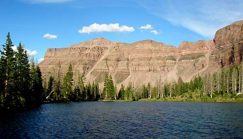
The gold "Meadow Peak"
Like most of the peaks of the Uintas, "Meadow Peak" has no official name. According to summitpost member Scott it gets its unofficial name from an old geology book. The summit is the typical Uinta pile of fractured rock.
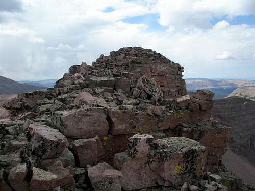
"Meadow Peak" summit
Getting There
East Fork Blacks Fork
If not coming from Salt Lake, find your way to Mountain View Wyoming and follow the directions from there.If coming from Salt Lake, head east on I80 to Wyoming. Once in Wyoming, take exit 34 towards Fort Bridger. Go through Fort Bridger about 5.1 miles to a 4 way intersection with a blinking red light. Turn right onto Wyoming State Route 414. Go through the town of Mountain View where there is a 24 hour Maverick gas station and convenience store, a small ShopKo, a Pizza Hut, and a Subway. At the south end of Mountain View, 3 miles from the blinking light, turn right onto Wyoming state route 410. After 13 miles you will see a sign that says the pavement ends in 750 feet. Shortly you will see another sign for "Blacks Fork River Access Area" and then another one that says "Wasatch Nat'l Forest/Meeks Cabin 13". If you miss all the signs, don't worry, the three sets of rumble strips should wake you up. Do as the signs say and turn left. The road you turn onto starts out paved but soon changes to dirt. Follow the main road 23.6 miles to the signboard (just past a gate) for the East Fork Blacks Fork Trail. The trail start is just before the signboard. There is no parking right at the trail start. Instead, continue on the road for just a few feet and turn right and then left into the parking lot.
In the summer of 2013, the dirt road was in excellent shape to Meeks Cabin Reservoir. Past the reservoir it was still good, but less so. Past the Utah/Wyoming state line, it degraded a little more but was still fine. Past the turn for the Mirror Lake Highway with about 5.5 miles to go to the trailhead, it got annoyingly bad with many rocks, both loose and embedded with most of the dirt washed away. I had no problem with a Subaru Legacy (not Outback), but had to drive pretty slow.
West Fork Blacks Fork
Via the Mirror Lake HighwayAt approximately mile marker 48.7, turn east onto forest road #058 which is a dirt road suitable for most passenger vehicles. Drive 16.2 miles and turn right onto forest road #063. This road starts out not so bad but will turn into a high clearance 4x4 road. Follow #063 5 miles to the stream ford. After the ford, it gets even rougher with huge dips filled with muddy water. Go an additional 1.2 miles to a locked gate.
Via Mountain View
Follow the directions for East Fork Blacks Fork, but after you turn off of 410, follow the main road for about 18.7 miles and then bear left on forest road #058 heading for the Mirror Lake Highway. After 2.3 miles turn left onto forest road #063 where the route joins that above.
Lake Fork
Find your way to Duchesne Utah, route 40. Turn north onto UT-87 and go 15.6 miles. Turn left onto 21000W, just after a big hairpin turn. Follow this road about 3.6 miles until it ends at a T intersection and turn right. The road quickly bends left at a 90 degree angle and you again head north following the signs to Moon Lake. Go about 13.9 miles and turn left into the parking area. This turn is at N40.56347 W110.49868. It is a large parking area as horse rides are run from it. The actual trail starts at the north end at N40.56448 W110.50234.Routes Overview
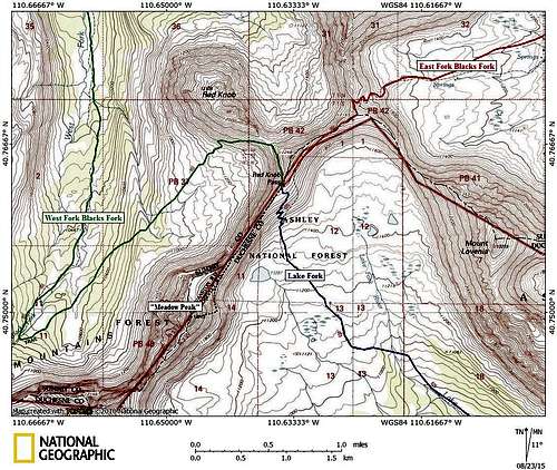
Meadow Peak Topo
All reasonable approaches are over 25 miles round trip, so the typical hiker would need 3 days to climb "Meadow Peak".

Approaching Red Knob Pass on the way to "Meadow Peak" at right.
On the north slope, "Meadow Peak" can be reached by either the East or West forks of Blacks Fork. On the south slope it can be reached via the Lake Fork Trail starting from Moon Lake. All three trails will take you to Red Knob Pass. From the pass, proceed along the ridge southwest to the base of the cliffs. Traverse under the cliffs to the left/south until you see a wide gully heading up. (N40.75012 W110.64339) Ascend the gully, which eventually opens up into a slope, to the summit.
 The cliffs
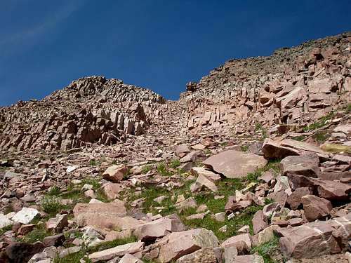
The wide gully
The East Fork of the Blacks Fork is very wet and many places you will be walking through calf high grass in standing water. In 2013 I managed to make all stream crossings in August without getting wet.
The West Fork of the Blacks Fork is also equally soggy, but only in some spots. i.e. most of the trail is dry, but when it is wet it's just as wet as the East Fork. There is one unbridged stream crossing where your feet will definitely get wet.
I haven't actually been on the Lake Fork Trail, only to the trailhead which is reached via a paved road. It is 20 miles or so on dirt to reach the East Fork Blacks Fork trailhead, but most carefully driven passenger cars can do it. You will need a high clearance 4x4 to reach the West Fork Blacks Fork trailhead and will be driving across 2 channels of the stream with water about 18" deep but with a nice gravel bottom.
South slope trails are generally considerably drier (and hotter) than north slope trails so I would expect the Lake Fork Trail to be not as wet as the East and West Forks of the Blacks Fork.
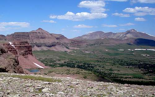
Lake Fork Basin, "Meadow Peak" left of center
It might be possible to get to "Meadow Peak" from "East Dead Horse Peak". Here is a picture showing most of the ridge between the two peaks. If you blow it up, you will see that there are some cliffs just before the low point on the ridge. As long as you can navigate or skirt these cliffs, you have it made.

The southwest ridge of "Meadow Peak"
Red Tape
Normal wilderness area restrictions apply. Check the signboard at the trailhead for the most up-to-date information. Do not camp within 200' of the trail or a water source.When to Climb
The summer hiking season typically runs from the beginning of July to mid September. However, some of the stream crossings on the East Fork Blacks Fork would be quite difficult at the beginning of July, but should be easier in August. I have been up the East Fork Blacks Fork in October, and the standing water was 3" deep or higher in many places.Winter ascents would be tough due to the access roads being unplowed. For the East Fork Blacks Fork Trailhead, plowing stops at the north end of the Meeks Cabin Reservoir, over 11 miles away, where there is a parking lot but no restroom. The road is then well snowmobiled and groomed to the turnoff for the Mirror Lake Highway. From this point, in February 2013, we saw just a few snowmobile tracks heading in the direction of the trailhead, so I think it possible, but not 100% certain that you would find a track all of the way to the trailhead.
There is a forest service Guard Station that can be rented out in the winter from the Evanston Ranger District. It is located about 1/4 mile past the turn to the summer campground/trailhead of the East Fork Blacks Fork. However, it is still a long way to get to "Meadow Peak", about 25 miles round trip, starting from the cabin. This is in addition to the 22+ miles round trip required to get to the cabin.
If you wanted to approach via the Mirror Lake Highway, the highway is not plowed between mile marker 15.6 (Soapstone Basin turnoff) and mile marker 48.7 (North Slope Road #058). Both end points have parking and restrooms.
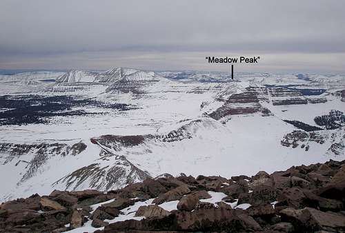
Winter view of "Meadow Peak" et al
Camping
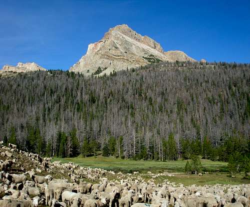
There is a campground just past the parking lot for the East Fork Blacks Fork with about 10 sites. It is free, but there is no water. It is extremely unlikely that you would find it full as I've never seen more than a couple of sites occupied and several times it's been completely empty.There are numerous places to camp along both the East Fork and the West Fork Blacks Fork trails, but remember that you need to be 200' away from the trail and any water source. Be warned that you might encounter sheep in the grassy meadows so it is best to camp above them.
West Fork Blacks Fork trail
External Links
Evanston-Mountain View Ranger DistrictEvanston Office: (307)789-3194
Mountain View Office: (307)782-6555
Bear River Ranger Station (closed in winter): (435)642-6662