

-
 58391 Hits
-
 85.52% Score
-
 21 Votes
|
|
Mountain/Rock |
|---|---|
|
|
36.78000°N / 118.377°W |
|
|
Fresno/Inyo |
|
|
Hiking, Mountaineering, Scrambling |
|
|
13011 ft / 3966 m |
|
|
History and Overview
Mt. Gould is on the Sierra Peaks Section (SPS) List. It was originally named University Peak by Joseph N. LeConte, whose party (including Hubert P. Dyer, Fred S. Pheby, and C. B. Lakeman) claimed the first ascent in 1890. Mr. LeConte was honoring the University of California, where he was professor of geology, natural history and botany. Six years later, LeConte changed his mind and transferred the name to the present University Peak after claiming the first ascent there (along with Helen Gompertz and Belle and Estelle Miller). On the following day he reclimbed today’s Mt. Gould and renamed the peak for his companion, Wilson S. Gould.
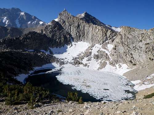
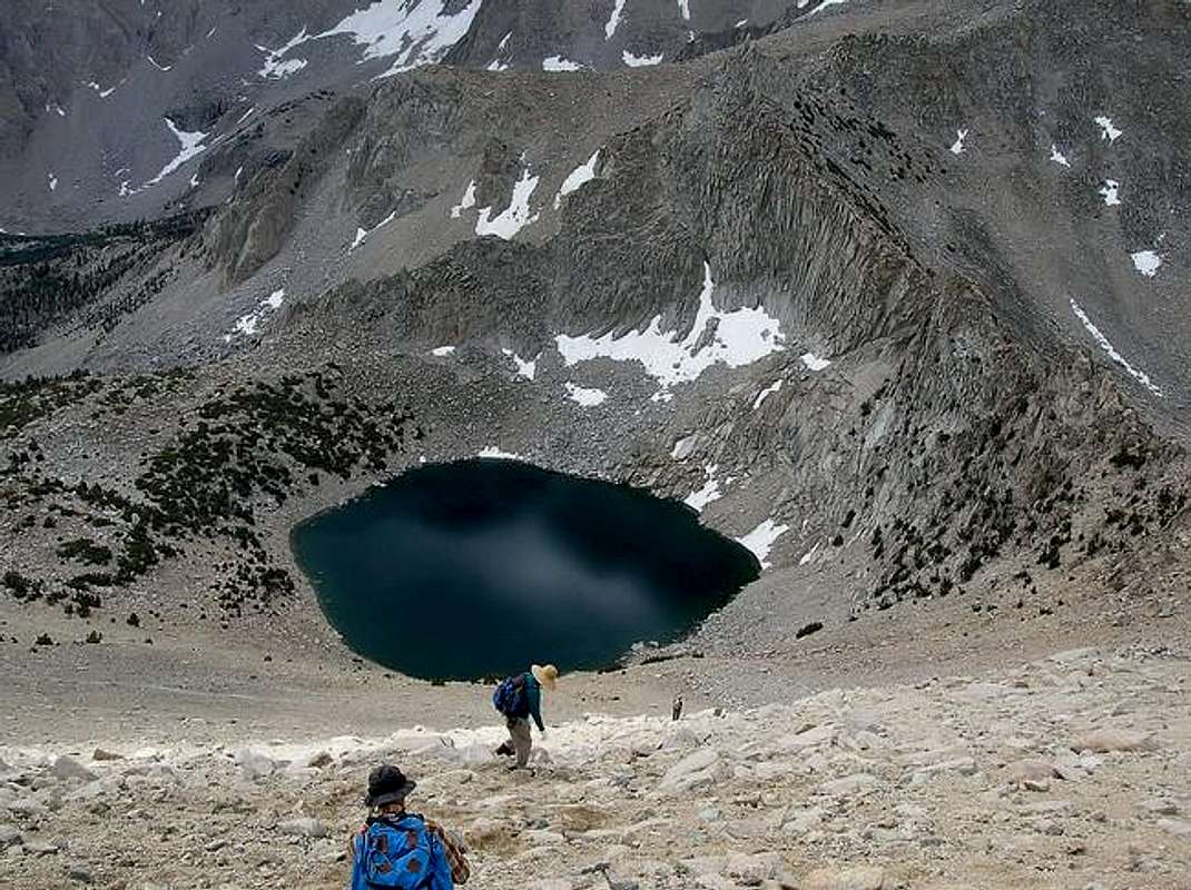
The peak is located in the Eastern Sierra just north of Kearsarge Pass, west of Independence, California. It is easily accessible from Onion Valley, and makes for an easy dayhike. Most hikers approach Mt. Gould via the Kearsarge Pass Trail, which extends 5.5 miles from Onion Valley to Kearsarge Pass (11,760 feet). The trail passes Gilbert Lake, Flower Lake, Heart Lake and Big Pothole Lake. From the pass the route is a simple cross-country jaunt of about 0.6 miles to the north, class 2 until the class 3 summit block is reached. Notable area peaks visible from the summit include Mt. Clarence King, Mt. Cotter, University Peak, Dragon Peak and Kearsarge Peak. Mt. Gould can also be approached from the Golden Trout Lakes Basin, and via a traverse from Dragon Peak.
Why Climb Mt. Gould?
It’s an easy 13er. This should appeal to someone who has never climbed above 13,000 feet, or someone who wants to acclimatize to 13,000 feet in a relatively easy, accessible way.
There are pretty lakes along the Kearsarge Pass Trail, and beautiful scenery from Kearsarge Pass and from the summit of Mt. Gould.
It’s not just a boring walk-up; it has a class 3 summit block. The climbing takes just a few minutes, though, so it’s a good introduction to class 3 summit blocks for a newbie.
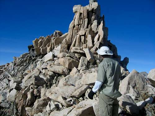
It's also a good introduction to cross-country scrambling for a novice, as the scrambling is not difficult or long. It includes a fun, time-saving scree descent down Mt. Gould's southeast slopes back to the trail.
 |
 |
 |
 |
Getting There
Turn west from Main Street (Hwy 395) in Independence, California onto paved Onion Valley Road, and take Onion Valley Road all the way to its end (about 14 miles from Independence). There is ample space for parking in the vicinity of the Kearsarge Pass trailhead.
 |
 |
 |
 |
 |
Red Tape
No permit is required for day hiking Mt. Gould, but overnight trips do require permits throughout the year.
Information on permits for overnight trips:
When To Climb
Onion Valley Road, the road to the Kearsarge Pass trailhead, is not plowed in winter. Most visitors to the area come in late spring through early fall.
Camping
There is a campground at the end of the road on the south side of Onion Valley at about 9,200 feet. Wilderness permits for backcountry camping can also be obtained. Gilbert Lake and Flower Lake provide pleasant camping options along the south side of the Kearsarge Pass Trail.
See Inyo National Forest camping information here:
External Links
Trip report by Bob Burd (including Dragon Peak and Mt. Rixford)
Bob Burd - Oct 29, 2002 9:40 pm - Hasn't voted
Untitled Comment"was named University Peak, in honor of the University of California, by J. N. LeConte and a party at the first ascent in 1890. On July 12, 1896, LeConte transferred that name to the present University Peak -- when, with Helen Gompertz and Belle and Estelle Miller, he made the first ascent. The following day he climbed the old University Peak and named it for his companion, Wilson S. Gould of Oakland."
- Erwin Gudde, California Place Names
Diesel - Aug 11, 2013 9:57 pm - Hasn't voted
Mount Gould day hikeActually this will take half day for an average hiker. My GPS said 11.5 miles roundtrip. That does not mean it is correct. Like any responsible hiker you are, check every source you come across for distances and times when it comes to hiking. From Independence, CA (Rt-395) take the road to Onion Valley. The entire road is asphalt, so no events there. Drive all the way to the end. The parking area is big but during the summer almost always full. If no parking in the parking area, park along the road. Remember this is bear country: store absolutely everything you have scented in the food metal containers provided at the trailhead. The bear will trash your car for a taste of that toothpaste of soap you have in the trunk. The trailhead is easy to find. The trail to Kearsage Pass that is. Follow this trail to the pass. Once you hit the pass which is at 11,700 ft, stop. Mount Gould is 90 degrees to ones right. Go uphill that brutal scramble. One will hit a false summit but Mount Gould will be easy to spot, if no clouds. Go to the summit, take pictures, enjoy the scenery and go down the way you went up. Ta-da! You just grabbed a 13,011 ft summit. Congratulations!