
-
 56491 Hits
-
 97.38% Score
-
 68 Votes
|
|
Mountain/Rock |
|---|---|
|
|
47.47030°N / 120.785°W |
|
|
8364 ft / 2549 m |
|
|
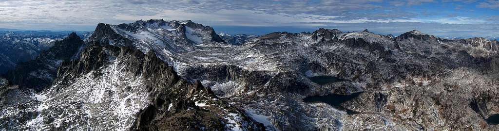
Overview
 McClellan Peak
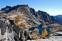 McClellan Peak
 McClellan Peak
 McClellan Peak
 McClellan Peak
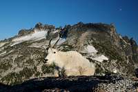 McClellan Peak
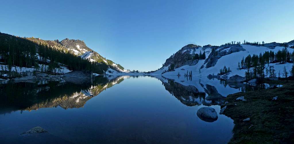
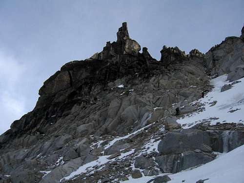
McClellan Peak sits in one of the most beautiful areas in all of the Washington Cascades, or for that fact, just about anywhere. The Enchantment Lake basin is home to not only McClellan Peak, but also Little Annapurna to the West and directly to the north is
McClellan is listed as the 88th highest summit in Washington State. If you are interested in what all of those 100 summits are, see this page by Klenke which shows all the highest 100 peaks in Washington which are known as the Bulgers.
McClellan Peak was named in honor of Captain George B. McClellan of the Corp of Engineers. He however never set foot on his namesake mountain. It's also interesting to note that Ingalls Creek was named after a U.S. Army Captain who explored this area in 1872 who was seeking after a gold mine. Ingalls Creek follows a valley for 16 miles and is one of the last untouched stretches of river wilderness left in the Cascades. Ingalls Creek drains mainly the Mt. Stuart range as well as creeks that come into it like Crystal creek. Somewhere in these mountains Captain Ingalls' lost gold mine still awaits discovery but the real gold is found in the value of the wilderness here. The gold is found every fall when the alpine larch trees turn their needles into a display of gold beauty that is unsurpassed.
Mount Stuart was named by the same McClellan that McClellan Peak is named for. He named the granite mass for his friend Jimmy Stuart in 1853. If you'd like to get a little more detail on the geology of this area and even more of the historical aspects, Fred Beckey's book has several worthwhile pages starting on page 233-239.
Getting There
 McClellan Peak
 McClellan Peak
 McClellan Peak
 McClellan Peak
 McClellan in snow
 McClellan Peak
McClellan Peak can be climbed from many different aspects and the route you take will dictate which trailhead you use. The more popular approach is from the north via Snow Creek and Snow Lakes or Mountaineer Creek and Aasgard Pass. These are the two typical Enchantment area trailheads. From Seattle there are two routes you could take to access these. You can get on I-90 and head east over Snoqualmie Pass to Cle Elum, taking the exit to Wenatchee and Blewett Pass via State Highway 970 and then US highway 97. Highway 97 takes you over Blewett Pass to a junction with US 2. Turn left towards Leavenworth. Go through Leavenworth and pass the Leavenworth ranger station until you come to the last road before you start to enter Tumwater canyon and turn left on Icicle road. This junction is signed and a 76 gas station is at this intersection. The second way to get to this trailhead from Seattle or the Everett area is to take US 2 over Stevens Pass to Leavenworth. When you come out of the canyon, turn right on the Icicle Creek Road.
The other major trailhead used to access McClellan Peak from the south is the Ingalls Creek trailhead. To access this trailhead, Take US Highway 97 north from I-90 over Blewett Pass to milepost 178 andwatch for the Ingalls Creek road No. 7312. Turn west across a bridge and then stay left until you come to the trail head in about one mile at the end of the road.
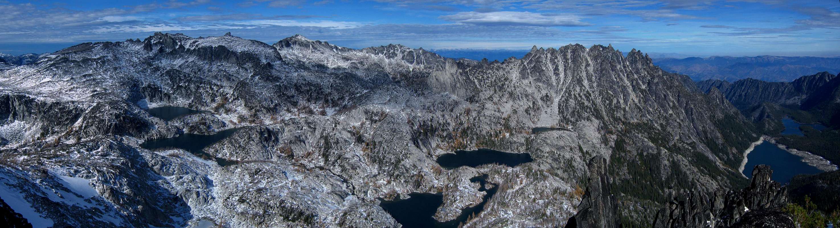
Approaches
 Upper Snow Lake
 McClellan Peak
 McClellan Peak
 McClellan Peak
 McClellan Peak
 McClellan Peak
 McClellan Peak
 McClellan Peak
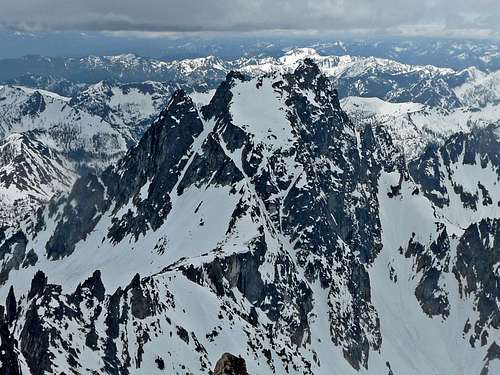
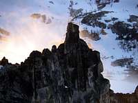 The Prong
 South face climb
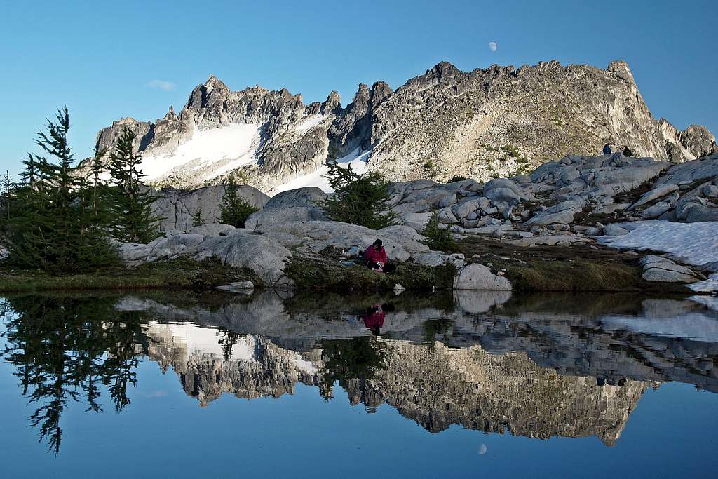
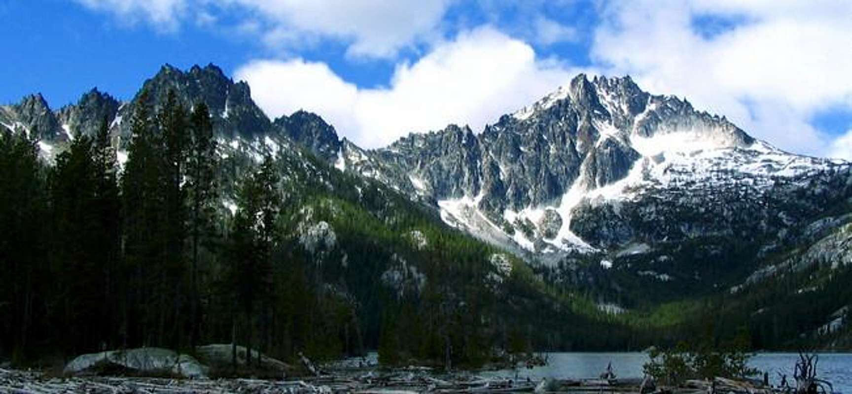
There are three ways to approach the standard north route on McClellan Peak. By far the most popular route is the Snow Creek Trail, taking off at the Snow Creek TH, which lies 4 miles up the Icicle Creek road. Elevation begins at 1300 feet and after a little drop down to a bridge across the Icicle River, it begins a series of switchbacks that lead upward and onward, never relenting until you come into the middle Enchantment Lake area, a distance of close to ten miles. Camping is possible at Nada or Snow Lakes if you get a late start. The elevation gain is close to 5400 feet or more, depending upon where you camp. A good area to camp at is just below the Rune Lake outlet. Mountain goats are plentiful and not one bit afraid of humans. They are known to seek out the salt from urine so it is recommended that we all answer nature's call on the rock rather than the fragile soil. Access to McClellan Peak can readily be made from the campsite just mentioned or from any of the lakes higher up.
The second approach follows the Mountaineer Creek trail (Colchuck Lake). It is 4.5 miles to Colchuck Lake and another 2.5 miles to Crystal Lake. It would make a very long day if you had to do it in a day however it can be done. The elevation gain from the TH to Colchuck Lake is 2000 feet (TH elevation 3300 feet). You then have to hike south around the lake on the trail for 0.5 mile and then gain 2200 feet in only 0.7 mile to the top of Aasgard Pass (7800 feet) before you enter the Core Enchantments Zone. Hike cross country easily across this area towards Crystal Lake. Traverse at about the 7,600 foot level across the Upper Enchantments heading ESE until you can overlook Crystal Lake. Descend 550 feet to its shore at 7,000 feet to meet the Crystal Creek Approach.
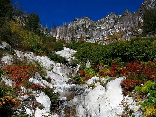
The third approach follows the Ingalls Creek Trail on the peaks south side. This is the one route where a regular Forest Service trail permit (no fee) can be utilized for camping as you actually don't camp in the Enchantment corridor. This is the "backdoor" approach. Start at the Ingalls Creek Trailhead and start on the trail which has a gentle grade and maintains this easy grade for mile after mile. The first 5.5 miles to the Falls Creek area gains only 1500 feet and makes a good place to camp if you get a late start. From here continue another 1.5 miles to a point where Crystal Creek drains into Ingalls Creek. You may see a sign denoting Crystal Creek. Follow the creek up just on its right side (where you might find cairns). There is no trail and the climb up this creek valley is rough and steep at times. A faint boot path can sometimes be followed, appearing and disappearing, but no matter, the way is up. Be sure to take plenty of water as the creek doesn't guarantee you'll find water again until you reach Crystal Lake. Continue up the valley climbing up small ribs and lots of talus reaching a small tarn (which may be dry in late season) 1000 feet below Crystal Lake. This makes a great place to camp. From the dry tarn, you can go right up into the Enchantments in about an hour following the obvious valley up to Crystal lake. This off trail route up Crystal Creek is best spread over two days as the total distance is close to ten miles and 5000 foot elevation gain. Remember, this is a cross country approach and common sense and route finding skills are helpful. Once at Crystal Lake you are in the Core Enchantments Zone and can meet up easily with the other approaches and the standard route (described in more detail below)
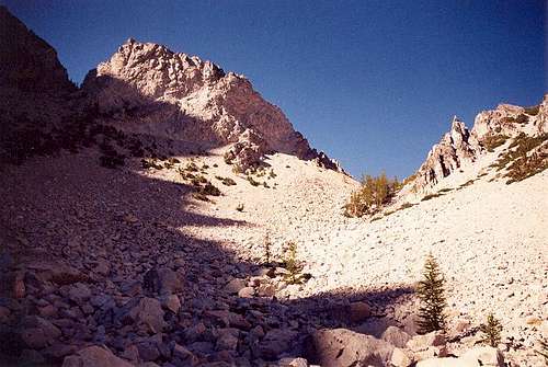 Upper Crystal Creek drainage near the small tarn
Route Options
Standard North Route - Class 3The kickoff point for this route is either Leprechaun Lake (if approaching via Snow Creek) or Crystal Lake (if approaching via Mountaineer or Crystal Creeks). From Leprechaun Lake, ascend yo talus or snow slopes SSW aiming to the left (west) of a prominent tower called The Prong. You may find some third class loose gullies depending on the route you take but if you stay left initially the terrain would be slightly easier. Begin curving left towards the southeast directly to the Prong. The terrain begins to steepen and you may find a small path which leads up a choke just right (west) of The Prong. Climb steep up to the base of the Prong and reach the crest of the west ridge at the top of the choke near the summit block just to the east of all the Chessmen. This final climb can prove difficult in late season if remaining snow is hard and icy. Check for conditions and plan accordingly by bringing crampons and ice axe if needed.
From Crystal Lake, climb due east up to a broad flat area at 7,400 feet and do an ascending traverse across talus or snow to the ESE aiming for the same choke just west of the Prong. This traverse can be very difficult in late season if any remnant snow is hard and icy. Plan accordingly.
From where you reach the west ridge, continue towards the summit block and climb third class rock to the summit where you will find a nice register which was full in October, 2012. Climbing the summit block is half the fun but the idea is to either climb its west face up some slabs or walk around to its southeast side where its more broken and easier.
 Descending the choke next to the Prong Descending the choke next to the Prong |  McClellan Peak summit block - West side McClellan Peak summit block - West side |
South Face - Class 3
This route starts out similar to the Crystal Creek Approach as it follows the Ingalls Creek Trail for 5.5 miles but then takes a twist. Instead of continuing to Crystal Creek, leave the trail at about 3,400 feet and begin hiking up the west (left) side of the draining leading to the tiny Fantasia Pond. The idea is to stay on the west side of the valley and on a small ridge to avoid the waterfalls then follow the creek bed when the slope eases to avoid bushwhacking through terrible slide alder. When the bushes end, cross to the east side of the creek and avoid hitting Fantasia Pond but veering east and to the right aiming directly for McClellan Peak. Enter a small basin east of Fantasia Pond and ascend a loose gully to reach the west ridge near the same spot the north route hits. Continue to the summit block from here.
 Climbing the creek bed to avoid slide alder Climbing the creek bed to avoid slide alder | 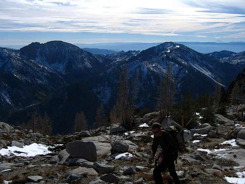 The Three Brothers from the south face The Three Brothers from the south face |
Maps
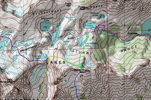 McClellan Peak North Map McClellan Peak North Map |  McClellan Peak South Map McClellan Peak South Map |
Summit Views
Red Tape
These days, in order to overnight in the Enchantments between June 15th and October 15th, you have to get a permit from the Leavenworth Ranger station. You will need to contact the Leavenworth Ranger Station to get the updated information.At the Trailheads, (Snow Creek, Mountaineer Creek, and Ingalls Creek) you need to display a Northwest Forest Service Pass or risk being ticketed. Holders of Enchantment permits are given parking passes to display during their allotted time however.
Obtain permits at the Leavenworth Ranger Station
600 Sherbourne Leavenworth, WA 98826
(509) 548-6977
US backcountry forest rangers do regularly patrol the Enchantment area and the main trails and if you encounter one of these rangers you will find them friendly and helpful but they will ALWAYS ask to see your permit. In the past six years, I've been stopped and checked three times. If you use the Ingalls Creek trailhead, fill out one of the free permits available at the trailhead and if stopped by a ranger in the Enchantment area, let them know you are camping in the Ingalls Creek zone which doesn't require you to win the lottery.
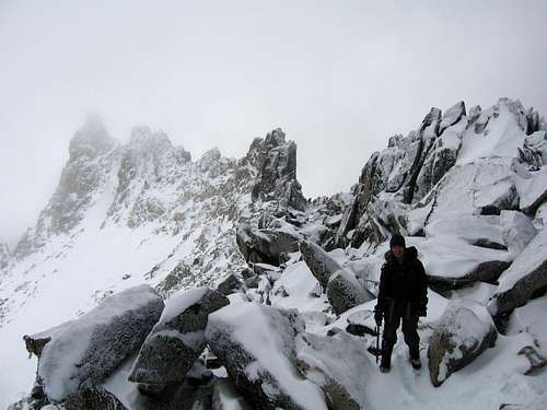
 Winter Conditions eh?
Rock Climbing near McClellan Peak
While McClellan itself is not much more than a scramble, located on its ridge or on its flanks are many worthwhile towers and peaks that are good for short rock climbs. Below is a list of a few of them. Becky's guide has enough beta to get you going. McClellan Peak is more than just a summit, it is a very rugged area with more stuff to climb than you can find the time to do.Tulip Towers
The Prong
The Chessmen (seven towers on the west ridge)
Window Tower
Orange Tower
Bloody Tower
Glockenspiel Tower
Crystal Lake Tower
Three Feathers
Nocturne Tower
Fire Spire
The Turle
Coney Rock
Cruel finger
All of these plus a drawing of the location and information on each can be found in Fred Beckey's amazing book, Cascade Alpine Guide, Columbia River to Steven's Pass, 3rd edition on pages 265-271.
 Rock climbing the Enchantments
Camping
The Enchantments are one of the great places to camp in the Washington Cascades and if you get a permit for the Enchantment Lakes themselves, there are plenty of places to camp at. No campfires are allowed so you need to bring a stove for your cooking needs.Camping is also available at Nada and Snow Lakes on the Snow Creek trail approach and at Colchuck Lake on the Aasgard Pass approach. On Ingalls creek there are several nice places to camp along the river and if you are looking for a car camping campground, the Eightmile campground off the Icicle Creek Road is a nice place. Leavenworth has a lot of motels but be warned, they are all expensive as Leavenworth is a very popular tourist town.
 Larch time in the Enchantments
Wildlife and other info
Gear shops: Leavenworth has two outdoor stores that can provide you with gear should you find your self needing something. Der Sportsman on the main tourist street across from a little park plaza has basic backpacking gear and there is a climbers/river rafter store that has climbing hardware and a lot of good information. It is just a block west from the ranger station on the same side of the street. The owners of this store are climbers and have a lot of beta on the area.Mountain goats and marmots are two of the most prevalent creatures to be found in this area. The mountain goats are not afraid of humans and are plentiful. Remember, they have horns and can pose a danger in certain situations but mainly they want the salt we provide in urine. The forest service urges everyone to 'pee' on the rocks, not on the ground as these animals will tear the fragile ground cover up attempting to get the salt. Marmots can often be found sunning themselves in the rocky areas (which is everywhere!). Do not leave any food or gear unattended as these animals will chew your stuff to oblivion. Bears and mountain lions are very rare and likely gone from the area.
Fishing? Oh yes, there are fish in the lakes and there are climbers who will supplement their larder with freshly caught fish. You must have a Washington state fishing license of course and these are obtainable at Der Sportsman in Leavenworth.
Nearby Mountains and Peaks / Maps
The Top 100Of the 100 highest mountains and peaks in the state of Washington, the Enchantment area and surrounding Stuart Range has ten of them.
Colchuck, Dragontail, Little Annapurna, Enchantment Peak, Cannon Mountain, Cashmere Mountain, Argonaut, Stuart, Sherpa, and of course, McClellan. Prusik Peak, while not one of the highest, might be the most popular of the area peaks sought out by climbers. A recent Issue of Rock and Ice featured Prusik on the inside back cover.
From the Seattle Mountaineers list of Washington's 100 highest peaks, here are the six within the Enchantment Core Zone. A good trip is to link all of them:
#26 - Dragontail Peak 8840 ft Excellent page
#33 - Colchuck Peak 8705 ft Excellent page
#38 - Cannon Mtn. 8638 ft
#52 - Enchantment pk 8520 ft
#70 - Little Annapurna 8440 ft
#88 - McClellan Peak 8364 ft
You could hit Cannon, then Enchantment, then McClellan, then Little Annapurna, then Dragontail, and finish with Colchuck. Just an idea of a perfect Bulger Blast!
 Dragontail Peak Dragontail Peak | 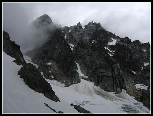 Colchuck Peak Colchuck Peak |
Whats in a name?
Well, one confusing situation that has developed over the years is the fact that three of the lakes in the Enchantment area are known by two different names. The US geological/quad maps refer to Inspiration, Perfection and Temple. In a field report by Chuck Hessey (reprinted in Signpost magazine of July 1996), he indicates that it was during his trip that the lakes that some of us call Talisman and Rune were named Inspiration and Perfection by his group. In the early 50's, Bill and Peg Stark felt that the names should be more magical and put their names on the area. Inspiration was Talisman and Perfection became Rune. Those names were never adopted so the current nomenclature is Inspiration and Perfection. Leprechaun and Lake Viviane were kept and their choice of Naid lake is now known as Temple Lake since it sits at the base of Temple Ridge. I myself prefer the Stark's names as I have a difficult time remembering which is which of the current quad map names since Inspiration and Perfection fit both of these lakes. Isolation lake in the Upper Enchantments was named Byrnhild by the Starks.Rock and Ice Article
In the November issue of Rock and Ice magazine (#119), just inside the back cover was a picture of Prusik Peak. Some route descriptions were included but most stunning was the picture of Prussik. In the recent issue, January's #121), a reader wrote in to voice objection to the fact that the magazine had focused on the Enchantment area (meaning Prusik in this case) and was concerned about the fact that not enough was said about the permit system and the heavy impact that this area is subject to. Overuse was the concern, too many people. Here's my 2 cents on that. The majority of people now coming into this area (wasn't always this way) understand the LNT ethic. You have to earn your way up to the Enchantments, you pay for it one upward step at a time. You are entitled but do be legal and get the required permit(s) and follow the rules of this fragile high country. It is there for all of us to enjoy so we need to take proper care of it. Here is a pic I took of Prusik that is from the same spot as the Rock and Ice photo.  |
External Links
Weather ForecastAvalanche Forecast
Lists of John
Erik Hoffman's climb from Ingalls Creek
Enchantment Lakes Sept 2001 Visit